
Mt. Mikusa
三草山
Nose, Osaka / Inagawa, Hyogo · Elevation 564 m
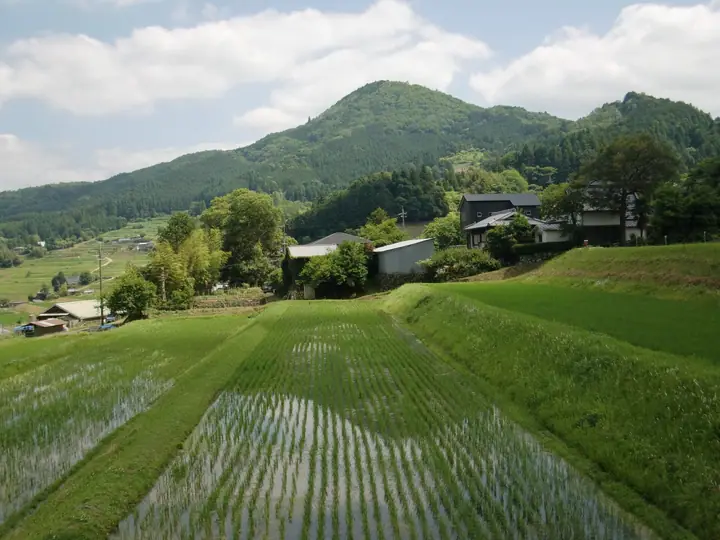
Mt. Mikusa is a 564 m satoyama summit on the boundary of Nose Town (Osaka) and Inagawa Town (Hyōgo), recorded under the ancient name Minume-yama. The 14.5 ha "Mikusayama Zephyrus Forest" on its lower slopes — a managed grove of Quercus glandulifera and serrata oaks — supports 10 of Japan's 25 Zephyrus hairstreak species, including the eastern range limit of the broad-bordered green hairstreak (Hirobi-midori-shijimi). Since 1992 the Osaka Green Trust public-interest foundation has overseen traditional satoyama management here, and Osaka Prefectural Nature Conservation Ordinance prohibits insect or animal collection in the forest. Listed in the Osaka 50 Mountains and Furusato Hyōgo 100.
Mt. Mikusa at a glance
- Weather: The most settled day in the next 7 days is Thu, November 5: clear, gusts up to 6 m/s.
Mt. Mikusa weather (hourly, 14 days)
Sunrise today 06:21, sunset 17:04
| Tue, 11/3 | Wed, 11/4 | Thu, 11/5 | Fri, 11/6 | Sat, 11/7 | Sun, 11/8 | Mon, 11/9 | Tue, 11/10 | Wed, 11/11 | Thu, 11/12 | Fri, 11/13 | Sat, 11/14 | Sun, 11/15 | Mon, 11/16 | Tue, 11/17 | |||||||||||||||||||||||||||||||||||||||||||||||||||||||||||||||||||||||
|---|---|---|---|---|---|---|---|---|---|---|---|---|---|---|---|---|---|---|---|---|---|---|---|---|---|---|---|---|---|---|---|---|---|---|---|---|---|---|---|---|---|---|---|---|---|---|---|---|---|---|---|---|---|---|---|---|---|---|---|---|---|---|---|---|---|---|---|---|---|---|---|---|---|---|---|---|---|---|---|---|---|---|---|---|---|
| Japan time | 21 | 23 | 1 | 3 | 5 | 7 | 9 | 11 | 13 | 15 | 17 | 19 | 21 | 0 | 3 | 6 | 9 | 12 | 15 | 18 | 21 | 0 | 3 | 6 | 9 | 12 | 15 | 18 | 21 | 0 | 3 | 6 | 9 | 12 | 15 | 18 | 21 | 0 | 3 | 6 | 9 | 12 | 15 | 18 | 21 | 0 | 3 | 6 | 9 | 12 | 15 | 21 | 3 | 9 | 15 | 21 | 3 | 9 | 15 | 21 | 3 | 9 | 15 | 21 | 3 | 9 | 15 | 21 | 3 | 9 | 15 | 21 | 3 | 9 | 15 | 21 | 3 | 9 | 15 | 21 | 3 | 9 | 15 | 21 | |
  | | | |   |   | |   | | | |   | |   | | |   | | |   | |   | | | |   |   | |  | | | | | | | | | | | | | | | | | | | | | | | | |  | | | | | |   |  | | | | | | | | | | | | | |   | | | | | | | | |  | ||
| Temperature | °C | 9° | 9° | 8° | 8° | 8° | 8° | 12° | 14° | 14° | 15° | 13° | 11° | 13° | 11° | 11° | 11° | 13° | 18° | 18° | 14° | 14° | 15° | 12° | 10° | 13° | 16° | 16° | 11° | 9° | 7° | 6° | 4° | 9° | 10° | 9° | 6° | 5° | 5° | 5° | 5° | 8° | 10° | 10° | 7° | 7° | 6° | 7° | 7° | 11° | 14° | 13° | 6° | 4° | 9° | 12° | 6° | 6° | 8° | 9° | 4° | 2° | 9° | 11° | 5° | 4° | 9° | 10° | 4° | 3° | 9° | 13° | 6° | 6° | 11° | 13° | 11° | 11° | 13° | 13° | 7° | 4° | 8° | 10° | 4° |
| Precipitation | mm | 1.1 | 1.8 | 2.4 | 0.2 | 0.2 | 0.2 | 0.2 | 0.6 | 0.8 | 0.2 | 0.2 | 0.2 | 0.1 | 2.7 | 3.0 | 0.2 | 1.0 | 0.2 | ||||||||||||||||||||||||||||||||||||||||||||||||||||||||||||||||||
| New snow | cm | ||||||||||||||||||||||||||||||||||||||||||||||||||||||||||||||||||||||||||||||||||||
| Snow depth | cm | 0 | 0 | 0 | 0 | 0 | 0 | 0 | 0 | 0 | 0 | 0 | 0 | 0 | 0 | 0 | 0 | 0 | 0 | 0 | 0 | 0 | 0 | 0 | 0 | 0 | 0 | 0 | 0 | 0 | 0 | 0 | 0 | 0 | 0 | 0 | 0 | 0 | 0 | 0 | 0 | 0 | 0 | 0 | 0 | 0 | 0 | 0 | 0 | 0 | 0 | 0 | 0 | 0 | 0 | 0 | 0 | 0 | 0 | 0 | 0 | 0 | 0 | 0 | 0 | 0 | 0 | 0 | 0 | 0 | 0 | 0 | 0 | 0 | 0 | 0 | 0 | 0 | 0 | 0 | 0 | 0 | 0 | 0 | 0 |
| Wind | m/s | 3 | 3 | 3 | 4 | 3 | 3 | 4 | 3 | 3 | 3 | 2 | 2 | 4 | 4 | 3 | 2 | 1 | 0 | 2 | 1 | 3 | 5 | 4 | 1 | 2 | 4 | 4 | 4 | 3 | 3 | 3 | 1 | 5 | 6 | 6 | 4 | 2 | 3 | 4 | 3 | 5 | 5 | 5 | 4 | 3 | 1 | 2 | 1 | 1 | 4 | 4 | 1 | 1 | 2 | 4 | 3 | 5 | 7 | 6 | 2 | 2 | 2 | 2 | 1 | 2 | 6 | 6 | 3 | 1 | 1 | 2 | 1 | 2 | 2 | 3 | 2 | 1 | 4 | 7 | 6 | 3 | 5 | 3 | 3 |
| Wind gusts | m/s | 7 | 7 | 7 | 7 | 8 | 7 | 9 | 9 | 8 | 7 | 5 | 5 | 8 | 8 | 8 | 5 | 4 | 3 | 6 | 6 | 5 | 11 | 11 | 8 | 6 | 10 | 9 | 9 | 7 | 6 | 6 | 6 | 12 | 13 | 13 | 13 | 8 | 6 | 8 | 8 | 11 | 12 | 12 | 11 | 7 | 5 | 3 | 3 | 4 | 10 | 10 | 8 | 3 | 6 | 11 | 8 | 13 | 14 | 15 | 13 | 5 | 5 | 7 | 5 | 4 | 12 | 13 | 12 | 6 | 5 | 6 | 5 | 3 | 6 | 7 | 8 | 5 | 10 | 15 | 16 | 13 | 11 | 11 | 8 |
| Wind dir. | ↓ | ↓ | ↓ | ↓ | ↓ | ↓ | ↓ | ↓ | ↓ | ↓ | ↓ | ↓ | ↓ | ↓ | ↓ | ↓ | ↓ | ↓ | ↓ | ↓ | ↓ | ↓ | ↓ | ↓ | ↓ | ↓ | ↓ | ↓ | ↓ | ↓ | ↓ | ↓ | ↓ | ↓ | ↓ | ↓ | ↓ | ↓ | ↓ | ↓ | ↓ | ↓ | ↓ | ↓ | ↓ | ↓ | ↓ | ↓ | ↓ | ↓ | ↓ | ↓ | ↓ | ↓ | ↓ | ↓ | ↓ | ↓ | ↓ | ↓ | ↓ | ↓ | ↓ | ↓ | ↓ | ↓ | ↓ | ↓ | ↓ | ↓ | ↓ | ↓ | ↓ | ↓ | ↓ | ↓ | ↓ | ↓ | ↓ | ↓ | ↓ | ↓ | ↓ | ↓ | |
Huts, campsites and lodging near Mt. Mikusa
Campsites
- campeggio
- 能勢温泉キャンプ場
Lists that include Mt. Mikusa
Mt. Mikusa facts
- Also known as
- 美奴売山
- Elevation
- 564 m
- Location
- Nose, Osaka / Inagawa, Hyogo
34.956395, 135.375611 - Website
- www.ogtrust.jp
- Wikipedia
- ja.wikipedia.org