
Mt. Ōsa
大麻山
Zentsūji-shi, Kagawa · Elevation 616 m
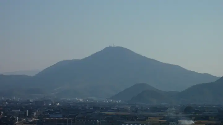
Mt. Ōsa is a 616.3 m peak on the boundary between Zentsūji City and Mitoyo City in Kagawa Prefecture, the highest free-standing summit in the prefecture. It is a designated site of the Sanuki Geopark, with a granite base capped by Mid-Miocene Sanukite andesite, and lies within Seto Inland Sea National Park. The summit ridge extends southeast to Mt. Kotohira (524 m), home of the Kompira-gū shrine. Around 800 double-flowering cherry trees bloom at the Ōsa-yama summit park in late April to early May, complemented by sweeping views over the Marugame Plain and the Ryūō-ike pond — a relic of an ancient fumarole. The peak is included on the Shikoku 100, the Japan 100 Low Mountains, the Kagawa Prefecture Mountain Guide, and other major Japanese mountain lists.
Mt. Ōsa at a glance
- Weather: The most settled day in the next 7 days is Thu, November 5: clear, gusts up to 6 m/s.
Mt. Ōsa weather (hourly, 14 days)
Sunrise today 06:26, sunset 17:11
| Tue, 11/3 | Wed, 11/4 | Thu, 11/5 | Fri, 11/6 | Sat, 11/7 | Sun, 11/8 | Mon, 11/9 | Tue, 11/10 | Wed, 11/11 | Thu, 11/12 | Fri, 11/13 | Sat, 11/14 | Sun, 11/15 | Mon, 11/16 | Tue, 11/17 | |||||||||||||||||||||||||||||||||||||||||||||||||||||||||||||||||||||||
|---|---|---|---|---|---|---|---|---|---|---|---|---|---|---|---|---|---|---|---|---|---|---|---|---|---|---|---|---|---|---|---|---|---|---|---|---|---|---|---|---|---|---|---|---|---|---|---|---|---|---|---|---|---|---|---|---|---|---|---|---|---|---|---|---|---|---|---|---|---|---|---|---|---|---|---|---|---|---|---|---|---|---|---|---|---|
| Japan time | 15 | 17 | 19 | 21 | 23 | 1 | 3 | 5 | 7 | 9 | 11 | 13 | 15 | 18 | 21 | 0 | 3 | 6 | 9 | 12 | 15 | 18 | 21 | 0 | 3 | 6 | 9 | 12 | 15 | 18 | 21 | 0 | 3 | 6 | 9 | 12 | 15 | 18 | 21 | 0 | 3 | 6 | 9 | 12 | 15 | 18 | 21 | 0 | 3 | 6 | 9 | 15 | 21 | 3 | 9 | 15 | 21 | 3 | 9 | 15 | 21 | 3 | 9 | 15 | 21 | 3 | 9 | 15 | 21 | 3 | 9 | 15 | 21 | 3 | 9 | 15 | 21 | 3 | 9 | 15 | 21 | 3 | 9 | 15 | |
 |   |   | | |   | | |   | | | | | |   | | |   |   | | |   | | |   | | | |   |  | | | | | | | | | | | | | | | | | | | | | | | | | | | | | | |   |  | | | | |   | | | | | | | | | | | | |   | |  | | | ||
| Temperature | °C | 14° | 12° | 11° | 10° | 10° | 9° | 9° | 8° | 9° | 12° | 14° | 14° | 14° | 11° | 11° | 10° | 10° | 10° | 12° | 17° | 17° | 15° | 14° | 13° | 13° | 12° | 14° | 16° | 15° | 12° | 9° | 8° | 8° | 7° | 9° | 11° | 11° | 8° | 6° | 4° | 2° | 2° | 9° | 12° | 11° | 7° | 8° | 7° | 7° | 7° | 11° | 13° | 8° | 6° | 10° | 12° | 8° | 6° | 8° | 10° | 6° | 2° | 8° | 11° | 6° | 6° | 10° | 12° | 5° | 1° | 9° | 13° | 6° | 5° | 12° | 15° | 11° | 12° | 13° | 15° | 9° | 5° | 7° | 10° |
| Precipitation | mm | 0.3 | 1.0 | 1.0 | 1.1 | 0.4 | 0.2 | 3.7 | 0.3 | 0.4 | 0.6 | 0.5 | 0.1 | 3.9 | 0.4 | 1.0 | 0.3 | ||||||||||||||||||||||||||||||||||||||||||||||||||||||||||||||||||||
| New snow | cm | ||||||||||||||||||||||||||||||||||||||||||||||||||||||||||||||||||||||||||||||||||||
| Snow depth | cm | 0 | 0 | 0 | 0 | 0 | 0 | 0 | 0 | 0 | 0 | 0 | 0 | 0 | 0 | 0 | 0 | 0 | 0 | 0 | 0 | 0 | 0 | 0 | 0 | 0 | 0 | 0 | 0 | 0 | 0 | 0 | 0 | 0 | 0 | 0 | 0 | 0 | 0 | 0 | 0 | 0 | 0 | 0 | 0 | 0 | 0 | 0 | 0 | 0 | 0 | 0 | 0 | 0 | 0 | 0 | 0 | 0 | 0 | 0 | 0 | 0 | 0 | 0 | 0 | 0 | 0 | 0 | 0 | 0 | 0 | 0 | 0 | 0 | 0 | 0 | 0 | 0 | 0 | 0 | 0 | 0 | 0 | 0 | 0 |
| Wind | m/s | 2 | 0 | 1 | 1 | 3 | 2 | 2 | 2 | 3 | 4 | 4 | 4 | 3 | 1 | 1 | 1 | 0 | 1 | 1 | 1 | 1 | 1 | 2 | 2 | 4 | 3 | 4 | 5 | 6 | 5 | 4 | 4 | 5 | 3 | 4 | 3 | 3 | 1 | 1 | 1 | 1 | 2 | 0 | 2 | 2 | 1 | 1 | 1 | 1 | 1 | 1 | 2 | 2 | 2 | 3 | 4 | 4 | 4 | 3 | 2 | 2 | 1 | 1 | 2 | 0 | 1 | 2 | 3 | 2 | 2 | 3 | 2 | 2 | 2 | 2 | 1 | 1 | 2 | 3 | 3 | 4 | 1 | 1 | 1 |
| Wind gusts | m/s | 6 | 6 | 1 | 3 | 7 | 6 | 5 | 5 | 6 | 9 | 10 | 10 | 9 | 7 | 4 | 6 | 3 | 3 | 3 | 4 | 6 | 4 | 4 | 5 | 9 | 8 | 10 | 12 | 13 | 13 | 12 | 9 | 10 | 10 | 10 | 10 | 9 | 8 | 4 | 3 | 3 | 4 | 4 | 6 | 6 | 5 | 3 | 3 | 3 | 2 | 4 | 8 | 5 | 4 | 7 | 11 | 10 | 10 | 9 | 8 | 6 | 3 | 4 | 7 | 5 | 4 | 4 | 9 | 8 | 4 | 6 | 7 | 6 | 5 | 5 | 5 | 5 | 6 | 8 | 10 | 11 | 8 | 4 | 6 |
| Wind dir. | ↓ | ↓ | ↓ | ↓ | ↓ | ↓ | ↓ | ↓ | ↓ | ↓ | ↓ | ↓ | ↓ | ↓ | ↓ | ↓ | ↓ | ↓ | ↓ | ↓ | ↓ | ↓ | ↓ | ↓ | ↓ | ↓ | ↓ | ↓ | ↓ | ↓ | ↓ | ↓ | ↓ | ↓ | ↓ | ↓ | ↓ | ↓ | ↓ | ↓ | ↓ | ↓ | ↓ | ↓ | ↓ | ↓ | ↓ | ↓ | ↓ | ↓ | ↓ | ↓ | ↓ | ↓ | ↓ | ↓ | ↓ | ↓ | ↓ | ↓ | ↓ | ↓ | ↓ | ↓ | ↓ | ↓ | ↓ | ↓ | ↓ | ↓ | ↓ | ↓ | ↓ | ↓ | ↓ | ↓ | ↓ | ↓ | ↓ | ↓ | ↓ | ↓ | ↓ | ↓ | |
Huts, campsites and lodging near Mt. Ōsa
Campsites
- 302 Osayama Camping Ground
Lodging
- Kotohira Hot Springs Kotosankaku
- 旅館とら丸
- Shikishimakan
- つるや旅館
- Kotori Coworking & Hostel Kotohira
Lists that include Mt. Ōsa
100 Low Mountains of Japan · Shikoku 100 Famous Mountains · 1000 Mountains of Japan
Mt. Ōsa facts
- Elevation
- 616 m
- Location
- Zentsūji-shi, Kagawa
34.196696, 133.788505 - National Park
- 瀬戸内海国立公園
- Website
- www.city.zentsuji.kagawa.jp
- Trail Map
- www.city.zentsuji.kagawa.jp (PDF)
- Wikipedia
- ja.wikipedia.org