
Mt. Oomuroyama
大室山
Fujikawaguchiko, Yamanashi · Elevation 1,468 m
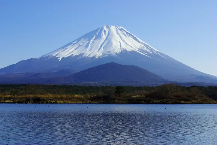
Ōmuroyama is a 1,468 m parasitic cone of Mount Fuji rising on the volcano's north-west flank in Fujikawaguchiko Town, Yamanashi Prefecture, lying within the Special Protection Zone of Fuji-Hakone-Izu National Park. From Lake Shōji it appears as a smaller summit cradled in front of Fuji, earning the nickname "Kodaki Fuji" (Fuji holding a child), and the 864 CE Jōgan eruption's lava flows split around its base to form the Aokigahara forest. There is no formal trail to the summit, but the surrounding beech forest and lava-tube ice caves are featured on the Yamanashi Hiking 100 selection and the peak is included in Kai 100.
Mt. Oomuroyama at a glance
- Weather: The most settled day in the next 7 days is Sun, November 8: clear, gusts up to 6 m/s.
Mt. Oomuroyama weather (hourly, 14 days)
Sunrise today 06:08, sunset 16:50
| Tue, 11/3 | Wed, 11/4 | Thu, 11/5 | Fri, 11/6 | Sat, 11/7 | Sun, 11/8 | Mon, 11/9 | Tue, 11/10 | Wed, 11/11 | Thu, 11/12 | Fri, 11/13 | Sat, 11/14 | Sun, 11/15 | Mon, 11/16 | Tue, 11/17 | |||||||||||||||||||||||||||||||||||||||||||||||||||||||||||||||||||||||
|---|---|---|---|---|---|---|---|---|---|---|---|---|---|---|---|---|---|---|---|---|---|---|---|---|---|---|---|---|---|---|---|---|---|---|---|---|---|---|---|---|---|---|---|---|---|---|---|---|---|---|---|---|---|---|---|---|---|---|---|---|---|---|---|---|---|---|---|---|---|---|---|---|---|---|---|---|---|---|---|---|---|---|---|---|---|
| Japan time | 15 | 17 | 19 | 21 | 23 | 1 | 3 | 5 | 7 | 9 | 11 | 13 | 15 | 18 | 21 | 0 | 3 | 6 | 9 | 12 | 15 | 18 | 21 | 0 | 3 | 6 | 9 | 12 | 15 | 18 | 21 | 0 | 3 | 6 | 9 | 12 | 15 | 18 | 21 | 0 | 3 | 6 | 9 | 12 | 15 | 18 | 21 | 0 | 3 | 6 | 9 | 15 | 21 | 3 | 9 | 15 | 21 | 3 | 9 | 15 | 21 | 3 | 9 | 15 | 21 | 3 | 9 | 15 | 21 | 3 | 9 | 15 | 21 | 3 | 9 | 15 | 21 | 3 | 9 | 15 | 21 | 3 | 9 | 15 | |
  |   |   | | | | | |   | | | | | | | | | |   |   | | |   |   | | |  | | |  | | | | | | | | | | | | |   | | | | | | | | | | | | |   | | | | |   | | | | | | | | | | | | | | | | | | | | | | | | ||
| Temperature | °C | 9° | 7° | 6° | 6° | 6° | 6° | 6° | 5° | 5° | 6° | 8° | 8° | 7° | 6° | 6° | 6° | 6° | 6° | 9° | 14° | 11° | 10° | 9° | 7° | 8° | 9° | 12° | 16° | 15° | 10° | 9° | 7° | 6° | 4° | 6° | 9° | 9° | 4° | 3° | 4° | 3° | 3° | 6° | 9° | 8° | 5° | 5° | 4° | 5° | 5° | 6° | 7° | 4° | 2° | 4° | 7° | 3° | 0° | 2° | 5° | 0° | 0° | 4° | 6° | 3° | 0° | 6° | 8° | 3° | 3° | 4° | 6° | 4° | 2° | 8° | 9° | 7° | 9° | 11° | 14° | 5° | 5° | 4° | 6° |
| Precipitation | mm | 0.1 | 0.2 | 0.1 | 0.6 | 0.4 | 8 | 15 | 12 | 3.0 | 2.0 | 1.0 | 0.2 | 1.8 | 0.6 | 0.2 | 13 | 25 | 0.9 | 1.7 | 0.5 | 0.3 | |||||||||||||||||||||||||||||||||||||||||||||||||||||||||||||||
| New snow | cm | ||||||||||||||||||||||||||||||||||||||||||||||||||||||||||||||||||||||||||||||||||||
| Snow depth | cm | 0 | 0 | 0 | 0 | 0 | 0 | 0 | 0 | 0 | 0 | 0 | 0 | 0 | 0 | 0 | 0 | 0 | 0 | 0 | 0 | 0 | 0 | 0 | 0 | 0 | 0 | 0 | 0 | 0 | 0 | 0 | 0 | 0 | 0 | 0 | 0 | 0 | 0 | 0 | 0 | 0 | 0 | 0 | 0 | 0 | 0 | 0 | 0 | 0 | 0 | 0 | 0 | 0 | 0 | 0 | 0 | 0 | 0 | 0 | 0 | 0 | 0 | 0 | 0 | 0 | 0 | 0 | 0 | 0 | 0 | 0 | 0 | 0 | 0 | 0 | 0 | 0 | 0 | 0 | 0 | 0 | 0 | 0 | 0 |
| Wind | m/s | 2 | 1 | 1 | 1 | 1 | 1 | 1 | 1 | 1 | 1 | 1 | 1 | 1 | 2 | 2 | 2 | 2 | 1 | 1 | 1 | 1 | 0 | 1 | 1 | 1 | 0 | 2 | 2 | 1 | 1 | 1 | 1 | 1 | 2 | 1 | 1 | 2 | 1 | 1 | 1 | 1 | 1 | 0 | 1 | 1 | 1 | 1 | 1 | 2 | 1 | 1 | 1 | 1 | 1 | 1 | 3 | 2 | 1 | 4 | 3 | 0 | 1 | 3 | 4 | 0 | 1 | 3 | 1 | 0 | 0 | 1 | 2 | 1 | 1 | 4 | 4 | 2 | 3 | 1 | 3 | 1 | 1 | 1 | 3 |
| Wind gusts | m/s | 7 | 6 | 5 | 5 | 5 | 4 | 3 | 3 | 4 | 5 | 5 | 6 | 5 | 6 | 6 | 8 | 8 | 8 | 7 | 5 | 5 | 5 | 4 | 4 | 4 | 4 | 6 | 7 | 6 | 4 | 4 | 3 | 4 | 5 | 7 | 7 | 6 | 5 | 3 | 4 | 4 | 4 | 4 | 5 | 6 | 6 | 5 | 5 | 6 | 6 | 6 | 8 | 6 | 6 | 6 | 11 | 10 | 7 | 15 | 14 | 9 | 5 | 8 | 13 | 10 | 3 | 8 | 9 | 4 | 3 | 3 | 6 | 6 | 5 | 11 | 13 | 11 | 12 | 10 | 8 | 8 | 6 | 5 | 10 |
| Wind dir. | ↓ | ↓ | ↓ | ↓ | ↓ | ↓ | ↓ | ↓ | ↓ | ↓ | ↓ | ↓ | ↓ | ↓ | ↓ | ↓ | ↓ | ↓ | ↓ | ↓ | ↓ | ↓ | ↓ | ↓ | ↓ | ↓ | ↓ | ↓ | ↓ | ↓ | ↓ | ↓ | ↓ | ↓ | ↓ | ↓ | ↓ | ↓ | ↓ | ↓ | ↓ | ↓ | ↓ | ↓ | ↓ | ↓ | ↓ | ↓ | ↓ | ↓ | ↓ | ↓ | ↓ | ↓ | ↓ | ↓ | ↓ | ↓ | ↓ | ↓ | ↓ | ↓ | ↓ | ↓ | ↓ | ↓ | ↓ | ↓ | ↓ | ↓ | ↓ | ↓ | ↓ | ↓ | ↓ | ↓ | ↓ | ↓ | ↓ | ↓ | ↓ | ↓ | ↓ | ↓ | |
Huts, campsites and lodging near Mt. Oomuroyama
Lodging
- リゾートペンションもとす
- ヴィラ本栖
- Motosu Phoenix Hotel
Mt. Oomuroyama facts
- Also known as
- 子抱き富士
- Elevation
- 1,468 m
- Location
- Fujikawaguchiko, Yamanashi
35.440835, 138.653609 - National Park
- 富士箱根伊豆国立公園
- Website
- yamanashi-hiking100.jp
- Wikipedia
- ja.wikipedia.org