
Mt. Nyoigatake
如意ヶ岳
Kyoto, Kyoto · Elevation 472 m
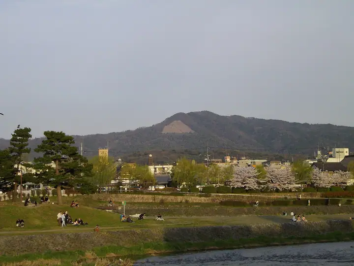
Nyoigatake is a 472-meter peak in Awataguchi, Sakyo Ward, Kyoto City, recognized as the high point of the Higashiyama Sanjurokuho range bordering the city's east side. Its western secondary summit, Mount Daimonji (465.4 m), is famed throughout Japan as the site of the giant 'dai' character lit each August 16 during the Gozan no Okuribi bonfire ceremony. In medieval times the mountainside hosted the great Nyoiji temple complex, and a fortress crowned the summit during the Sengoku period. The standard hiking approach climbs from behind Ginkakuji Temple via Mount Daimonji and along the ridge to the summit.
Mt. Nyoigatake at a glance
- Weather: The most settled day in the next 7 days is Wed, November 4: clear, gusts up to 7 m/s.
Mt. Nyoigatake weather (hourly, 14 days)
Sunrise today 06:19, sunset 17:02
| Tue, 11/3 | Wed, 11/4 | Thu, 11/5 | Fri, 11/6 | Sat, 11/7 | Sun, 11/8 | Mon, 11/9 | Tue, 11/10 | Wed, 11/11 | Thu, 11/12 | Fri, 11/13 | Sat, 11/14 | Sun, 11/15 | Mon, 11/16 | Tue, 11/17 | |||||||||||||||||||||||||||||||||||||||||||||||||||||||||||||||||||||||
|---|---|---|---|---|---|---|---|---|---|---|---|---|---|---|---|---|---|---|---|---|---|---|---|---|---|---|---|---|---|---|---|---|---|---|---|---|---|---|---|---|---|---|---|---|---|---|---|---|---|---|---|---|---|---|---|---|---|---|---|---|---|---|---|---|---|---|---|---|---|---|---|---|---|---|---|---|---|---|---|---|---|---|---|---|---|
| Japan time | 15 | 17 | 19 | 21 | 23 | 1 | 3 | 5 | 7 | 9 | 11 | 13 | 15 | 18 | 21 | 0 | 3 | 6 | 9 | 12 | 15 | 18 | 21 | 0 | 3 | 6 | 9 | 12 | 15 | 18 | 21 | 0 | 3 | 6 | 9 | 12 | 15 | 18 | 21 | 0 | 3 | 6 | 9 | 12 | 15 | 18 | 21 | 0 | 3 | 6 | 9 | 15 | 21 | 3 | 9 | 15 | 21 | 3 | 9 | 15 | 21 | 3 | 9 | 15 | 21 | 3 | 9 | 15 | 21 | 3 | 9 | 15 | 21 | 3 | 9 | 15 | 21 | 3 | 9 | 15 | 21 | 3 | 9 | 15 | |
  | |   | | | | | | | | | |   |   |   |   | |   |   | |  |  | | | | | | | | | | | | | | | | | | | | |   | | | | | | | | |   |   | | | |   | | | | |  | | | | | | | | | | | | | |   | | | | | | | | | ||
| Temperature | °C | 17° | 14° | 12° | 12° | 11° | 10° | 10° | 9° | 9° | 13° | 16° | 17° | 16° | 14° | 13° | 13° | 13° | 13° | 14° | 16° | 17° | 15° | 14° | 13° | 14° | 13° | 16° | 18° | 18° | 13° | 11° | 10° | 9° | 7° | 11° | 12° | 11° | 8° | 7° | 6° | 6° | 6° | 10° | 12° | 12° | 10° | 9° | 9° | 9° | 8° | 11° | 14° | 8° | 7° | 9° | 14° | 9° | 7° | 10° | 10° | 8° | 5° | 9° | 13° | 7° | 6° | 11° | 11° | 7° | 4° | 9° | 14° | 8° | 7° | 12° | 14° | 12° | 12° | 14° | 14° | 9° | 7° | 9° | 13° |
| Precipitation | mm | 5 | 7 | 2.2 | 1.1 | 0.3 | 0.5 | 0.2 | 0.2 | 0.1 | 0.5 | 0.5 | 3.2 | 3.4 | 0.3 | 0.2 | |||||||||||||||||||||||||||||||||||||||||||||||||||||||||||||||||||||
| New snow | cm | ||||||||||||||||||||||||||||||||||||||||||||||||||||||||||||||||||||||||||||||||||||
| Snow depth | cm | 0 | 0 | 0 | 0 | 0 | 0 | 0 | 0 | 0 | 0 | 0 | 0 | 0 | 0 | 0 | 0 | 0 | 0 | 0 | 0 | 0 | 0 | 0 | 0 | 0 | 0 | 0 | 0 | 0 | 0 | 0 | 0 | 0 | 0 | 0 | 0 | 0 | 0 | 0 | 0 | 0 | 0 | 0 | 0 | 0 | 0 | 0 | 0 | 0 | 0 | 0 | 0 | 0 | 0 | 0 | 0 | 0 | 0 | 0 | 0 | 0 | 0 | 0 | 0 | 0 | 0 | 0 | 0 | 0 | 0 | 0 | 0 | 0 | 0 | 0 | 0 | 0 | 0 | 0 | 0 | 0 | 0 | 0 | 0 |
| Wind | m/s | 3 | 2 | 1 | 0 | 1 | 1 | 1 | 0 | 0 | 1 | 2 | 2 | 2 | 2 | 1 | 1 | 2 | 2 | 1 | 1 | 1 | 1 | 1 | 1 | 1 | 1 | 4 | 4 | 5 | 4 | 3 | 3 | 2 | 2 | 5 | 5 | 4 | 2 | 1 | 1 | 1 | 0 | 1 | 4 | 2 | 1 | 1 | 0 | 0 | 1 | 1 | 3 | 1 | 1 | 1 | 4 | 4 | 3 | 4 | 5 | 1 | 1 | 1 | 1 | 1 | 1 | 2 | 4 | 0 | 0 | 0 | 0 | 1 | 1 | 2 | 2 | 2 | 0 | 1 | 5 | 3 | 1 | 1 | 2 |
| Wind gusts | m/s | 7 | 7 | 5 | 3 | 2 | 3 | 4 | 3 | 2 | 3 | 6 | 7 | 7 | 5 | 5 | 5 | 4 | 4 | 4 | 4 | 4 | 4 | 3 | 3 | 7 | 5 | 10 | 10 | 11 | 11 | 10 | 9 | 9 | 7 | 12 | 13 | 13 | 10 | 5 | 3 | 4 | 3 | 4 | 9 | 9 | 6 | 3 | 2 | 2 | 3 | 4 | 8 | 7 | 3 | 5 | 11 | 10 | 12 | 10 | 15 | 13 | 4 | 5 | 7 | 6 | 4 | 6 | 12 | 11 | 3 | 3 | 5 | 3 | 3 | 5 | 7 | 6 | 4 | 5 | 12 | 13 | 9 | 4 | 6 |
| Wind dir. | ↓ | ↓ | ↓ | ↓ | ↓ | ↓ | ↓ | ↓ | ↓ | ↓ | ↓ | ↓ | ↓ | ↓ | ↓ | ↓ | ↓ | ↓ | ↓ | ↓ | ↓ | ↓ | ↓ | ↓ | ↓ | ↓ | ↓ | ↓ | ↓ | ↓ | ↓ | ↓ | ↓ | ↓ | ↓ | ↓ | ↓ | ↓ | ↓ | ↓ | ↓ | ↓ | ↓ | ↓ | ↓ | ↓ | ↓ | ↓ | ↓ | ↓ | ↓ | ↓ | ↓ | ↓ | ↓ | ↓ | ↓ | ↓ | ↓ | ↓ | ↓ | ↓ | ↓ | ↓ | ↓ | ↓ | ↓ | ↓ | ↓ | ↓ | ↓ | ↓ | ↓ | ↓ | ↓ | ↓ | ↓ | ↓ | ↓ | ↓ | ↓ | ↓ | ↓ | ↓ | |
Huts, campsites and lodging near Mt. Nyoigatake
Campsites
- 大文字山キャンプ場
Lodging
- Hiei Mountain House
- Roku Roku
- ビジネスホテル西大津
- 植木屋
- 桜谷町47
Mt. Nyoigatake facts
- Also known as
- 如意ヶ嶽
- Elevation
- 472 m
- Location
- Kyoto, Kyoto
35.016874, 135.825954 - Wikipedia
- ja.wikipedia.org