
Mt. Daimonji
大文字山
Kyoto, Kyoto · Elevation 465 m
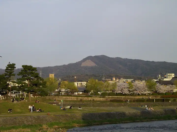
Mt. Daimonji is a 465 m peak in Sakyō-ku, Kyoto City, forming the western foresummit of the main Nyoigadake peak (472 m) in the Higashiyama range. Its slopes hold the firebed of the giant 大 character lit in Kyoto's annual Gozan no Okuribi ceremony on August 16. Trails from Ginkaku-ji, the Philosopher's Path and Keage form part of the Kyoto Circuit Trail's Higashiyama Course, and the summit offers a sweeping view across the Kyoto basin. It is included in the Hyaku-teizan and other regional mountain lists.
Mt. Daimonji at a glance
- Weather: The most settled day in the next 7 days is Wed, November 4: clear, gusts up to 7 m/s.
- Route: The shortest is Mount Daimonji Out-and-Back from Ginkaku-ji: about 2 h 29 min, 4.3 km, about 390 m of climbing.
Mt. Daimonji weather (hourly, 14 days)
Sunrise today 06:19, sunset 17:02
| Tue, 11/3 | Wed, 11/4 | Thu, 11/5 | Fri, 11/6 | Sat, 11/7 | Sun, 11/8 | Mon, 11/9 | Tue, 11/10 | Wed, 11/11 | Thu, 11/12 | Fri, 11/13 | Sat, 11/14 | Sun, 11/15 | Mon, 11/16 | Tue, 11/17 | |||||||||||||||||||||||||||||||||||||||||||||||||||||||||||||||||||||||
|---|---|---|---|---|---|---|---|---|---|---|---|---|---|---|---|---|---|---|---|---|---|---|---|---|---|---|---|---|---|---|---|---|---|---|---|---|---|---|---|---|---|---|---|---|---|---|---|---|---|---|---|---|---|---|---|---|---|---|---|---|---|---|---|---|---|---|---|---|---|---|---|---|---|---|---|---|---|---|---|---|---|---|---|---|---|
| Japan time | 15 | 17 | 19 | 21 | 23 | 1 | 3 | 5 | 7 | 9 | 11 | 13 | 15 | 18 | 21 | 0 | 3 | 6 | 9 | 12 | 15 | 18 | 21 | 0 | 3 | 6 | 9 | 12 | 15 | 18 | 21 | 0 | 3 | 6 | 9 | 12 | 15 | 18 | 21 | 0 | 3 | 6 | 9 | 12 | 15 | 18 | 21 | 0 | 3 | 6 | 9 | 15 | 21 | 3 | 9 | 15 | 21 | 3 | 9 | 15 | 21 | 3 | 9 | 15 | 21 | 3 | 9 | 15 | 21 | 3 | 9 | 15 | 21 | 3 | 9 | 15 | 21 | 3 | 9 | 15 | 21 | 3 | 9 | 15 | |
  | |   | | | | | | | | | |   |   |   |   | |   |   | |  |  | | | | | | | | | | | | | | | | | | | | |   | | | | | | | | |   |   | | | |   | | | | |  | | | | | | | | | | | | | |   | | | | | | | | | ||
| Temperature | °C | 17° | 14° | 12° | 12° | 11° | 10° | 10° | 9° | 9° | 13° | 16° | 17° | 16° | 14° | 14° | 13° | 13° | 13° | 14° | 16° | 17° | 15° | 14° | 13° | 14° | 13° | 16° | 18° | 18° | 13° | 11° | 10° | 9° | 8° | 11° | 12° | 11° | 8° | 7° | 6° | 6° | 6° | 10° | 12° | 12° | 10° | 9° | 9° | 9° | 8° | 11° | 14° | 8° | 7° | 9° | 14° | 9° | 7° | 11° | 10° | 8° | 5° | 9° | 13° | 7° | 6° | 11° | 11° | 7° | 4° | 9° | 14° | 8° | 7° | 12° | 14° | 12° | 12° | 14° | 14° | 9° | 7° | 9° | 13° |
| Precipitation | mm | 5 | 7 | 2.2 | 1.1 | 0.3 | 0.5 | 0.2 | 0.2 | 0.1 | 0.5 | 0.5 | 3.2 | 3.4 | 0.3 | 0.2 | |||||||||||||||||||||||||||||||||||||||||||||||||||||||||||||||||||||
| New snow | cm | ||||||||||||||||||||||||||||||||||||||||||||||||||||||||||||||||||||||||||||||||||||
| Snow depth | cm | 0 | 0 | 0 | 0 | 0 | 0 | 0 | 0 | 0 | 0 | 0 | 0 | 0 | 0 | 0 | 0 | 0 | 0 | 0 | 0 | 0 | 0 | 0 | 0 | 0 | 0 | 0 | 0 | 0 | 0 | 0 | 0 | 0 | 0 | 0 | 0 | 0 | 0 | 0 | 0 | 0 | 0 | 0 | 0 | 0 | 0 | 0 | 0 | 0 | 0 | 0 | 0 | 0 | 0 | 0 | 0 | 0 | 0 | 0 | 0 | 0 | 0 | 0 | 0 | 0 | 0 | 0 | 0 | 0 | 0 | 0 | 0 | 0 | 0 | 0 | 0 | 0 | 0 | 0 | 0 | 0 | 0 | 0 | 0 |
| Wind | m/s | 3 | 2 | 1 | 0 | 1 | 1 | 1 | 0 | 0 | 1 | 2 | 2 | 2 | 2 | 1 | 1 | 2 | 2 | 1 | 1 | 1 | 1 | 1 | 1 | 1 | 1 | 4 | 4 | 5 | 4 | 3 | 3 | 2 | 2 | 5 | 5 | 4 | 2 | 1 | 1 | 1 | 0 | 1 | 4 | 2 | 1 | 1 | 0 | 0 | 1 | 1 | 3 | 1 | 1 | 1 | 4 | 4 | 3 | 4 | 5 | 1 | 1 | 1 | 1 | 1 | 1 | 2 | 4 | 0 | 0 | 0 | 0 | 1 | 1 | 2 | 2 | 2 | 0 | 1 | 5 | 3 | 1 | 1 | 2 |
| Wind gusts | m/s | 7 | 7 | 5 | 3 | 2 | 3 | 4 | 3 | 2 | 3 | 6 | 7 | 7 | 5 | 5 | 5 | 4 | 4 | 4 | 4 | 4 | 4 | 3 | 3 | 7 | 5 | 10 | 10 | 11 | 11 | 10 | 9 | 9 | 7 | 12 | 13 | 13 | 10 | 5 | 3 | 4 | 3 | 4 | 9 | 9 | 6 | 3 | 2 | 2 | 3 | 4 | 8 | 7 | 3 | 5 | 11 | 10 | 12 | 10 | 15 | 13 | 4 | 5 | 7 | 6 | 4 | 6 | 12 | 11 | 3 | 3 | 5 | 3 | 3 | 5 | 7 | 6 | 4 | 5 | 12 | 13 | 9 | 4 | 6 |
| Wind dir. | ↓ | ↓ | ↓ | ↓ | ↓ | ↓ | ↓ | ↓ | ↓ | ↓ | ↓ | ↓ | ↓ | ↓ | ↓ | ↓ | ↓ | ↓ | ↓ | ↓ | ↓ | ↓ | ↓ | ↓ | ↓ | ↓ | ↓ | ↓ | ↓ | ↓ | ↓ | ↓ | ↓ | ↓ | ↓ | ↓ | ↓ | ↓ | ↓ | ↓ | ↓ | ↓ | ↓ | ↓ | ↓ | ↓ | ↓ | ↓ | ↓ | ↓ | ↓ | ↓ | ↓ | ↓ | ↓ | ↓ | ↓ | ↓ | ↓ | ↓ | ↓ | ↓ | ↓ | ↓ | ↓ | ↓ | ↓ | ↓ | ↓ | ↓ | ↓ | ↓ | ↓ | ↓ | ↓ | ↓ | ↓ | ↓ | ↓ | ↓ | ↓ | ↓ | ↓ | ↓ | |
Mt. Daimonji hiking routes
- Mount Daimonji Out-and-Back from Ginkaku-ji 4.3 km · Ascent 391 m Main Gate, バンブーガレージ (parking)
- Mount Daimonji and Daimonji Fire Bed Return from Ginkaku-ji 5.1 km · Ascent 400 m Ginkakuji-mae (Ginkakuji Temple) (Bus stop), Ginkakuji-michi (Bus stop), 銀閣寺前 パーキング, 銀閣寺前 エコキューブ, Times
- Ginkaku-ji Temple, Mount Daimonji, and Nanzen-ji Temple Traverse 5.8 km · Ascent 390 m Main Gate, バンブーガレージ (parking) → Nanzenji Eikando-michi (Bus stop), Okazaki Hosshojicho (Bus stop), エコロパーク岡崎動物園前 (parking)
- Keage to Ginkakuji over Mount Daimonji and the Bonfire Site 6.2 km · Ascent 444 m 蹴上駅 (Station), Keage (Station), Keage (Ferry terminal), 蹴上 (Bus stop) (parking) → Main Gate, バンブーガレージ (parking)
Hiking times are estimates calculated from the terrain.
Huts, campsites and lodging near Mt. Daimonji
Campsites
- 大文字山キャンプ場
Lodging
- Roku Roku
- 桜谷町47
- Hostel Ginkakujiホステル銀閣寺
- ホテル 平安の森 京都
- Nanzen Building
Lists that include Mt. Daimonji
Mt. Daimonji facts
- Also known as
- 如意ヶ嶽
- Elevation
- 465 m
- Location
- Kyoto, Kyoto
35.019638, 135.811728 - Website
- ja.kyoto.travel
- Wikipedia
- ja.wikipedia.org