
Mt. Nuki
貫山
Kitakyūshū, Fukuoka · Elevation 712 m
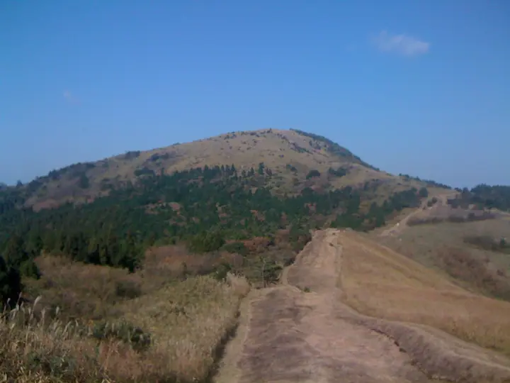
Mt. Nuki is a 711.6 m peak in Kokura-Minami Ward of Kitakyushu City, Fukuoka Prefecture, and the highest summit of Hirao-dai, one of the three great karst plateaus of Japan. Listed among the 100 Famous Mountains of Kyushu, it forms the heart of Kitakyushu Quasi-National Park and the nationally designated Hirao-dai Natural Monument. White limestone outcrops scattered across its grassy slopes resemble grazing sheep, and the summit gives views over Suō Bay and central Kitakyushu. Kitakyushu City publishes a dedicated Nuki-san / Hirao-dai trekking map, and trailheads at Fukiage Pass and Chagatoko Garden make it a popular short ascent.
Mt. Nuki at a glance
- Weather: The most settled day in the next 7 days is Sun, November 8: clear, gusts up to 7 m/s.
- Route: The shortest is Mount Nukisan Return from Chagatoko Garden via Naka Pass: about 2 h 52 min, 5.8 km, about 320 m of climbing.
Mt. Nuki weather (hourly, 14 days)
Sunrise today 06:37, sunset 17:23
| Tue, 11/3 | Wed, 11/4 | Thu, 11/5 | Fri, 11/6 | Sat, 11/7 | Sun, 11/8 | Mon, 11/9 | Tue, 11/10 | Wed, 11/11 | Thu, 11/12 | Fri, 11/13 | Sat, 11/14 | Sun, 11/15 | Mon, 11/16 | Tue, 11/17 | |||||||||||||||||||||||||||||||||||||||||||||||||||||||||||||||||||||||
|---|---|---|---|---|---|---|---|---|---|---|---|---|---|---|---|---|---|---|---|---|---|---|---|---|---|---|---|---|---|---|---|---|---|---|---|---|---|---|---|---|---|---|---|---|---|---|---|---|---|---|---|---|---|---|---|---|---|---|---|---|---|---|---|---|---|---|---|---|---|---|---|---|---|---|---|---|---|---|---|---|---|---|---|---|---|
| Japan time | 15 | 17 | 19 | 21 | 23 | 1 | 3 | 5 | 7 | 9 | 11 | 13 | 15 | 18 | 21 | 0 | 3 | 6 | 9 | 12 | 15 | 18 | 21 | 0 | 3 | 6 | 9 | 12 | 15 | 18 | 21 | 0 | 3 | 6 | 9 | 12 | 15 | 18 | 21 | 0 | 3 | 6 | 9 | 12 | 15 | 18 | 21 | 0 | 3 | 6 | 9 | 15 | 21 | 3 | 9 | 15 | 21 | 3 | 9 | 15 | 21 | 3 | 9 | 15 | 21 | 3 | 9 | 15 | 21 | 3 | 9 | 15 | 21 | 3 | 9 | 15 | 21 | 3 | 9 | 15 | 21 | 3 | 9 | 15 | |
  | |   |   | | | | |   | |   | | |   | | | | | |   |   |   | | | | | |  | |  | | | | | | | | | | | | | | | | | | | | | |   | | | | | |   | | |   |  | | | | | | | | | | | | | | |   | | | | | | | | ||
| Temperature | °C | 15° | 13° | 11° | 10° | 9° | 9° | 9° | 9° | 9° | 12° | 13° | 14° | 14° | 12° | 12° | 11° | 11° | 11° | 14° | 15° | 16° | 14° | 14° | 13° | 11° | 10° | 14° | 14° | 12° | 8° | 7° | 6° | 5° | 5° | 8° | 10° | 10° | 6° | 5° | 3° | 2° | 3° | 8° | 10° | 11° | 9° | 8° | 7° | 7° | 7° | 11° | 12° | 7° | 5° | 10° | 11° | 7° | 7° | 8° | 10° | 5° | 1° | 8° | 11° | 5° | 3° | 10° | 13° | 7° | 7° | 9° | 12° | 9° | 8° | 10° | 11° | 11° | 11° | 13° | 14° | 9° | 8° | 9° | 12° |
| Precipitation | mm | 0.5 | 0.3 | 0.1 | 0.4 | 1.2 | 2.6 | 0.6 | 0.3 | 0.1 | 0.4 | 0.1 | 4.7 | 22 | 11 | 0.1 | 0.4 | 0.2 | |||||||||||||||||||||||||||||||||||||||||||||||||||||||||||||||||||
| New snow | cm | ||||||||||||||||||||||||||||||||||||||||||||||||||||||||||||||||||||||||||||||||||||
| Snow depth | cm | 0 | 0 | 0 | 0 | 0 | 0 | 0 | 0 | 0 | 0 | 0 | 0 | 0 | 0 | 0 | 0 | 0 | 0 | 0 | 0 | 0 | 0 | 0 | 0 | 0 | 0 | 0 | 0 | 0 | 0 | 0 | 0 | 0 | 0 | 0 | 0 | 0 | 0 | 0 | 0 | 0 | 0 | 0 | 0 | 0 | 0 | 0 | 0 | 0 | 0 | 0 | 0 | 0 | 0 | 0 | 0 | 0 | 0 | 0 | 0 | 0 | 0 | 0 | 0 | 0 | 0 | 0 | 0 | 0 | 0 | 0 | 0 | 0 | 0 | 0 | 0 | 0 | 0 | 0 | 0 | 0 | 0 | 0 | 0 |
| Wind | m/s | 3 | 2 | 2 | 2 | 1 | 1 | 2 | 2 | 2 | 4 | 5 | 4 | 4 | 3 | 3 | 1 | 1 | 2 | 3 | 3 | 1 | 3 | 4 | 3 | 3 | 2 | 4 | 6 | 5 | 3 | 4 | 4 | 3 | 3 | 4 | 3 | 3 | 1 | 1 | 0 | 0 | 0 | 0 | 2 | 2 | 0 | 0 | 1 | 1 | 1 | 1 | 3 | 1 | 1 | 2 | 5 | 1 | 3 | 3 | 3 | 1 | 2 | 1 | 3 | 1 | 1 | 0 | 2 | 1 | 2 | 3 | 3 | 1 | 1 | 1 | 1 | 2 | 2 | 3 | 4 | 4 | 3 | 2 | 1 |
| Wind gusts | m/s | 7 | 7 | 5 | 5 | 4 | 3 | 4 | 4 | 4 | 8 | 11 | 11 | 10 | 9 | 8 | 6 | 3 | 3 | 7 | 8 | 10 | 10 | 10 | 9 | 8 | 7 | 10 | 13 | 14 | 12 | 8 | 9 | 9 | 8 | 10 | 10 | 9 | 8 | 3 | 2 | 2 | 2 | 2 | 6 | 7 | 6 | 2 | 2 | 3 | 4 | 4 | 9 | 8 | 4 | 6 | 12 | 11 | 9 | 9 | 8 | 8 | 4 | 4 | 8 | 8 | 3 | 4 | 7 | 7 | 6 | 8 | 9 | 7 | 3 | 6 | 9 | 7 | 6 | 7 | 11 | 10 | 9 | 7 | 8 |
| Wind dir. | ↓ | ↓ | ↓ | ↓ | ↓ | ↓ | ↓ | ↓ | ↓ | ↓ | ↓ | ↓ | ↓ | ↓ | ↓ | ↓ | ↓ | ↓ | ↓ | ↓ | ↓ | ↓ | ↓ | ↓ | ↓ | ↓ | ↓ | ↓ | ↓ | ↓ | ↓ | ↓ | ↓ | ↓ | ↓ | ↓ | ↓ | ↓ | ↓ | ↓ | ↓ | ↓ | ↓ | ↓ | ↓ | ↓ | ↓ | ↓ | ↓ | ↓ | ↓ | ↓ | ↓ | ↓ | ↓ | ↓ | ↓ | ↓ | ↓ | ↓ | ↓ | ↓ | ↓ | ↓ | ↓ | ↓ | ↓ | ↓ | ↓ | ↓ | ↓ | ↓ | ↓ | ↓ | ↓ | ↓ | ↓ | ↓ | ↓ | ↓ | ↓ | ↓ | ↓ | ↓ | |
Mt. Nuki hiking routes
- Mount Nukisan Return from Chagatoko Garden via Naka Pass 5.8 km · Ascent 317 m 茶ヶ床園地駐車場
- Hiraodai Fukiage Pass–Ohirayama and Nukisan Circuit 7.4 km · Ascent 468 m 吹上峠休憩所 公衆トイレ (parking)
Hiking times are estimates calculated from the terrain.
Huts, campsites and lodging near Mt. Nuki
Campsites
- 目白洞キャンプ場
Lists that include Mt. Nuki
100 Fujis of Japan · Kyushu 100 Famous Mountains · Elevations of 1003 Mountains of Japan
Mt. Nuki facts
- Elevation
- 712 m
- Location
- Kitakyūshū, Fukuoka
33.780752, 130.909363 - National Park
- 北九州国定公園
- Website
- www.city.kitakyushu.lg.jp
- Wikipedia
- ja.wikipedia.org