
Mt. Kuromoriyama
黒森山
Morioka, Iwate · Elevation 837 m
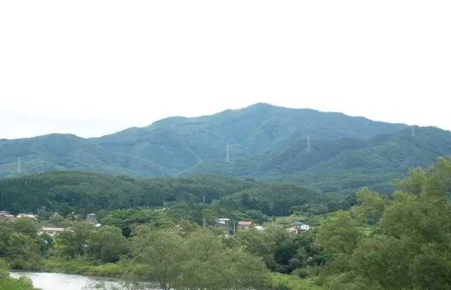
Kuromoriyama (837.3 m) is a wooded peak on the border between the Ōgayū district of Morioka City and Shiwa Town, on the western flank of the Kitakami Mountains in Iwate Prefecture. Viewed from southern Morioka it stands out as the highest, most pyramidal of the so-called Otobe Three Mountains together with Asashimayama and Onigaseyama. Active gold mining and smelting took place here until 1943, and a Kuromori-Daigongen shrine remains nestled among large rocks midway up. It is included on the Tohoku 100 and Iwate 100 mountain lists.
Mt. Kuromoriyama at a glance
- Weather: The most settled day in the next 7 days is Wed, November 4: clear, gusts up to 7 m/s. Sat, Nov 7, Sun, Nov 8: strong wind (gusts up to 18 m/s).
Mt. Kuromoriyama weather (hourly, 14 days)
Sunrise today 06:05, sunset 16:32
| Tue, 11/3 | Wed, 11/4 | Thu, 11/5 | Fri, 11/6 | Sat, 11/7 | Sun, 11/8 | Mon, 11/9 | Tue, 11/10 | Wed, 11/11 | Thu, 11/12 | Fri, 11/13 | Sat, 11/14 | Sun, 11/15 | Mon, 11/16 | Tue, 11/17 | |||||||||||||||||||||||||||||||||||||||||||||||||||||||||||||||||||||||
|---|---|---|---|---|---|---|---|---|---|---|---|---|---|---|---|---|---|---|---|---|---|---|---|---|---|---|---|---|---|---|---|---|---|---|---|---|---|---|---|---|---|---|---|---|---|---|---|---|---|---|---|---|---|---|---|---|---|---|---|---|---|---|---|---|---|---|---|---|---|---|---|---|---|---|---|---|---|---|---|---|---|---|---|---|---|
| Japan time | 15 | 17 | 19 | 21 | 23 | 1 | 3 | 5 | 7 | 9 | 11 | 13 | 15 | 18 | 21 | 0 | 3 | 6 | 9 | 12 | 15 | 18 | 21 | 0 | 3 | 6 | 9 | 12 | 15 | 18 | 21 | 0 | 3 | 6 | 9 | 12 | 15 | 18 | 21 | 0 | 3 | 6 | 9 | 12 | 15 | 18 | 21 | 0 | 3 | 6 | 9 | 15 | 21 | 3 | 9 | 15 | 21 | 3 | 9 | 15 | 21 | 3 | 9 | 15 | 21 | 3 | 9 | 15 | 21 | 3 | 9 | 15 | 21 | 3 | 9 | 15 | 21 | 3 | 9 | 15 | 21 | 3 | 9 | 15 | |
  |  | | | |   | | | |  | | | | | | |   |   |   | | | | | |   | |   |   | |   | | | |   |   | | |   | |   | | | | |   | | | | | | | |   | | | | | | |   | | | |   | | | | | | | | |  | | | | | | | | | | | | ||
| Temperature | °C | 6° | 3° | 2° | 1° | 0° | 0° | 0° | 2° | 2° | 6° | 9° | 10° | 9° | 4° | 3° | 3° | 4° | 5° | 7° | 8° | 9° | 8° | 8° | 8° | 8° | 7° | 10° | 11° | 10° | 7° | 3° | 1° | 0° | 0° | 0° | 2° | 1° | 0° | 0° | 0° | 0° | 0° | 2° | 4° | 2° | 0° | -1° | 0° | 0° | -2° | 3° | 3° | -2° | -4° | 1° | 5° | 1° | 2° | 0° | 1° | 0° | -3° | 2° | 4° | 1° | 1° | 1° | 2° | -3° | -4° | 0° | 5° | -1° | -2° | 4° | 8° | 4° | 4° | 6° | 4° | -2° | -5° | 0° | 3° |
| Precipitation | mm | 1.3 | 4.4 | 4.8 | 1.4 | 1.4 | 1.2 | 1.0 | 1.6 | 0.1 | 1.1 | 1.3 | 0.3 | 0.1 | 0.3 | 0.4 | 0.6 | 0.8 | 2.1 | 0.6 | 0.1 | 0.6 | 4.5 | 3.4 | 2.5 | 2.0 | 0.3 | 2.5 | 2.2 | 1.2 | 1.5 | ||||||||||||||||||||||||||||||||||||||||||||||||||||||
| New snow | cm | <.1 | 0.4 | 1.5 | 0.2 | <.1 | <.1 | 0.2 | <.1 | 0.4 | |||||||||||||||||||||||||||||||||||||||||||||||||||||||||||||||||||||||||||
| Snow depth | cm | 0 | 0 | 0 | 0 | 0 | 0 | 0 | 0 | 0 | 0 | 0 | 0 | 0 | 0 | 0 | 0 | 0 | 0 | 0 | 0 | 0 | 0 | 0 | 0 | 0 | 0 | 0 | 0 | 0 | 0 | 0 | 0 | 0 | 0 | <1 | <1 | <1 | <1 | <1 | <1 | <1 | <1 | 0 | 0 | 0 | 0 | 0 | 0 | 0 | 0 | 0 | 0 | 0 | 0 | 0 | 0 | 0 | 0 | 0 | 0 | 0 | 0 | 0 | 0 | 0 | 0 | 0 | 0 | 0 | 0 | 0 | 0 | 0 | 0 | 0 | 0 | 0 | 0 | 0 | 0 | 0 | 0 | 0 | 0 |
| Wind | m/s | 5 | 3 | 2 | 2 | 1 | 3 | 2 | 2 | 2 | 2 | 2 | 3 | 2 | 2 | 3 | 3 | 3 | 3 | 3 | 1 | 1 | 1 | 1 | 2 | 1 | 1 | 1 | 3 | 4 | 3 | 4 | 3 | 4 | 4 | 3 | 5 | 7 | 5 | 5 | 5 | 5 | 4 | 6 | 7 | 6 | 3 | 2 | 2 | 2 | 2 | 3 | 3 | 1 | 1 | 1 | 3 | 3 | 0 | 5 | 6 | 2 | 1 | 1 | 3 | 3 | 1 | 3 | 4 | 3 | 2 | 1 | 2 | 2 | 1 | 1 | 2 | 3 | 1 | 1 | 4 | 4 | 2 | 3 | 3 |
| Wind gusts | m/s | 12 | 11 | 7 | 6 | 5 | 5 | 6 | 5 | 5 | 6 | 7 | 7 | 7 | 4 | 5 | 6 | 6 | 7 | 7 | 7 | 3 | 2 | 3 | 5 | 5 | 3 | 5 | 11 | 11 | 10 | 10 | 11 | 10 | 10 | 11 | 17 | 18 | 15 | 11 | 11 | 11 | 11 | 14 | 17 | 17 | 13 | 6 | 5 | 5 | 5 | 7 | 10 | 8 | 2 | 4 | 8 | 11 | 8 | 12 | 17 | 13 | 5 | 4 | 9 | 8 | 6 | 9 | 11 | 10 | 7 | 5 | 6 | 5 | 4 | 3 | 7 | 6 | 7 | 4 | 13 | 10 | 9 | 7 | 8 |
| Wind dir. | ↓ | ↓ | ↓ | ↓ | ↓ | ↓ | ↓ | ↓ | ↓ | ↓ | ↓ | ↓ | ↓ | ↓ | ↓ | ↓ | ↓ | ↓ | ↓ | ↓ | ↓ | ↓ | ↓ | ↓ | ↓ | ↓ | ↓ | ↓ | ↓ | ↓ | ↓ | ↓ | ↓ | ↓ | ↓ | ↓ | ↓ | ↓ | ↓ | ↓ | ↓ | ↓ | ↓ | ↓ | ↓ | ↓ | ↓ | ↓ | ↓ | ↓ | ↓ | ↓ | ↓ | ↓ | ↓ | ↓ | ↓ | ↓ | ↓ | ↓ | ↓ | ↓ | ↓ | ↓ | ↓ | ↓ | ↓ | ↓ | ↓ | ↓ | ↓ | ↓ | ↓ | ↓ | ↓ | ↓ | ↓ | ↓ | ↓ | ↓ | ↓ | ↓ | ↓ | ↓ | |
Lists that include Mt. Kuromoriyama
Mt. Kuromoriyama facts
- Elevation
- 837 m
- Location
- Morioka, Iwate
39.603688, 141.277657 - Wikipedia
- ja.wikipedia.org