
Mt. Karasuba
烏場山
Minamiboso, Chiba · Elevation 267 m
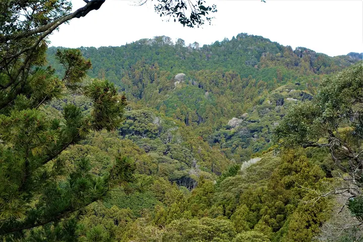
Mt. Karasuba (267 m) sits on the border of Minami-Bōsō and Kamogawa cities in Chiba, on the Bōsō Hills (Mineoka Range), and is included in Motoo Iwasaki's "New 100 Famous Mountains of Japan." The classic loop hike from coastal Wadaura over the summit and back—called the "Hanayome Kaidō" (Bride's Road) and "Hanamuko" (Bridegroom) Course—takes its name from a local legend of bridal processions that once crossed the ridge, and was first laid out by the Wadaura Walking Club in the 1970s; it is now maintained by the local tourism association. The route is dotted with sights such as the great Kyōmon Stone and the moss-clad Kurotaki waterfall, and it is reached on foot from JR Wadaura Station, making it a favourite winter hike from the Tokyo area.
Mt. Karasuba at a glance
- Weather: The most settled day in the next 7 days is Fri, November 6: clear, gusts up to 6 m/s.
Mt. Karasuba weather (hourly, 14 days)
Sunrise today 06:02, sunset 16:45
| Tue, 11/3 | Wed, 11/4 | Thu, 11/5 | Fri, 11/6 | Sat, 11/7 | Sun, 11/8 | Mon, 11/9 | Tue, 11/10 | Wed, 11/11 | Thu, 11/12 | Fri, 11/13 | Sat, 11/14 | Sun, 11/15 | Mon, 11/16 | Tue, 11/17 | |||||||||||||||||||||||||||||||||||||||||||||||||||||||||||||||||||||||
|---|---|---|---|---|---|---|---|---|---|---|---|---|---|---|---|---|---|---|---|---|---|---|---|---|---|---|---|---|---|---|---|---|---|---|---|---|---|---|---|---|---|---|---|---|---|---|---|---|---|---|---|---|---|---|---|---|---|---|---|---|---|---|---|---|---|---|---|---|---|---|---|---|---|---|---|---|---|---|---|---|---|---|---|---|---|
| Japan time | 15 | 17 | 19 | 21 | 23 | 1 | 3 | 5 | 7 | 9 | 11 | 13 | 15 | 18 | 21 | 0 | 3 | 6 | 9 | 12 | 15 | 18 | 21 | 0 | 3 | 6 | 9 | 12 | 15 | 18 | 21 | 0 | 3 | 6 | 9 | 12 | 15 | 18 | 21 | 0 | 3 | 6 | 9 | 12 | 15 | 18 | 21 | 0 | 3 | 6 | 9 | 15 | 21 | 3 | 9 | 15 | 21 | 3 | 9 | 15 | 21 | 3 | 9 | 15 | 21 | 3 | 9 | 15 | 21 | 3 | 9 | 15 | 21 | 3 | 9 | 15 | 21 | 3 | 9 | 15 | 21 | 3 | 9 | 15 | |
  |   |   | |   | | | |   | |   | | | | | | | | | |   | |   |   | | |  | | |  | |   | | |   | | | | | | | | | | | | | | | | | | | | |   | |   | | | |  | | | | | | | | | | | | | | | | | | | | | | | ||
| Temperature | °C | 18° | 17° | 17° | 17° | 16° | 16° | 15° | 15° | 15° | 16° | 16° | 16° | 16° | 14° | 17° | 16° | 19° | 13° | 15° | 16° | 16° | 16° | 17° | 15° | 15° | 15° | 18° | 20° | 20° | 20° | 19° | 16° | 15° | 15° | 15° | 17° | 17° | 16° | 14° | 12° | 12° | 11° | 12° | 14° | 14° | 14° | 14° | 14° | 12° | 11° | 11° | 13° | 12° | 11° | 11° | 12° | 10° | 15° | 13° | 14° | 11° | 9° | 12° | 14° | 12° | 10° | 13° | 15° | 9° | 8° | 11° | 13° | 14° | 14° | 16° | 18° | 19° | 18° | 20° | 20° | 14° | 12° | 11° | 12° |
| Precipitation | mm | 0.2 | 0.4 | 0.2 | 0.4 | 0.4 | 0.6 | 1.2 | 3.8 | 8 | 17 | 24 | 33 | 2.8 | 1.6 | 10 | 10 | 11 | 0.5 | 1.3 | 0.1 | 0.9 | 1.4 | 0.9 | 0.3 | 1.3 | 4.5 | 1.2 | 2.1 | 2.2 | 0.5 | 0.1 | 2.1 | 2.9 | 30 | 12 | |||||||||||||||||||||||||||||||||||||||||||||||||
| New snow | cm | ||||||||||||||||||||||||||||||||||||||||||||||||||||||||||||||||||||||||||||||||||||
| Snow depth | cm | 0 | 0 | 0 | 0 | 0 | 0 | 0 | 0 | 0 | 0 | 0 | 0 | 0 | 0 | 0 | 0 | 0 | 0 | 0 | 0 | 0 | 0 | 0 | 0 | 0 | 0 | 0 | 0 | 0 | 0 | 0 | 0 | 0 | 0 | 0 | 0 | 0 | 0 | 0 | 0 | 0 | 0 | 0 | 0 | 0 | 0 | 0 | 0 | 0 | 0 | 0 | 0 | 0 | 0 | 0 | 0 | 0 | 0 | 0 | 0 | 0 | 0 | 0 | 0 | 0 | 0 | 0 | 0 | 0 | 0 | 0 | 0 | 0 | 0 | 0 | 0 | 0 | 0 | 0 | 0 | 0 | 0 | 0 | 0 |
| Wind | m/s | 5 | 5 | 5 | 5 | 6 | 5 | 5 | 7 | 7 | 7 | 8 | 8 | 8 | 6 | 8 | 6 | 4 | 9 | 8 | 7 | 3 | 2 | 3 | 3 | 3 | 2 | 2 | 3 | 3 | 2 | 4 | 3 | 3 | 3 | 4 | 3 | 2 | 3 | 5 | 6 | 6 | 6 | 4 | 4 | 4 | 4 | 4 | 6 | 6 | 7 | 6 | 7 | 7 | 8 | 7 | 5 | 4 | 5 | 7 | 7 | 6 | 4 | 3 | 2 | 4 | 4 | 4 | 6 | 6 | 5 | 6 | 3 | 1 | 3 | 4 | 7 | 9 | 10 | 10 | 4 | 6 | 6 | 6 | 6 |
| Wind gusts | m/s | 8 | 8 | 8 | 8 | 9 | 9 | 8 | 10 | 11 | 11 | 12 | 13 | 11 | 12 | 11 | 11 | 11 | 14 | 15 | 12 | 10 | 5 | 6 | 6 | 6 | 5 | 5 | 6 | 5 | 5 | 6 | 6 | 7 | 5 | 6 | 6 | 5 | 5 | 9 | 10 | 10 | 10 | 9 | 7 | 7 | 7 | 7 | 8 | 9 | 11 | 11 | 10 | 11 | 11 | 12 | 11 | 8 | 7 | 13 | 14 | 11 | 10 | 7 | 6 | 6 | 8 | 7 | 9 | 10 | 10 | 9 | 9 | 6 | 5 | 5 | 10 | 13 | 17 | 15 | 13 | 12 | 10 | 11 | 10 |
| Wind dir. | ↓ | ↓ | ↓ | ↓ | ↓ | ↓ | ↓ | ↓ | ↓ | ↓ | ↓ | ↓ | ↓ | ↓ | ↓ | ↓ | ↓ | ↓ | ↓ | ↓ | ↓ | ↓ | ↓ | ↓ | ↓ | ↓ | ↓ | ↓ | ↓ | ↓ | ↓ | ↓ | ↓ | ↓ | ↓ | ↓ | ↓ | ↓ | ↓ | ↓ | ↓ | ↓ | ↓ | ↓ | ↓ | ↓ | ↓ | ↓ | ↓ | ↓ | ↓ | ↓ | ↓ | ↓ | ↓ | ↓ | ↓ | ↓ | ↓ | ↓ | ↓ | ↓ | ↓ | ↓ | ↓ | ↓ | ↓ | ↓ | ↓ | ↓ | ↓ | ↓ | ↓ | ↓ | ↓ | ↓ | ↓ | ↓ | ↓ | ↓ | ↓ | ↓ | ↓ | ↓ | |
Huts, campsites and lodging near Mt. Karasuba
Lodging
- 高鶴山荘
- Minshuku Jinza
- 若千葉荘
Lists that include Mt. Karasuba
Mt. Karasuba facts
- Elevation
- 267 m
- Location
- Minamiboso, Chiba
35.081370, 140.025167 - Website
- www.mboso-etoko.jp
- Trail Map
- www.mboso-etoko.jp (PDF)
- Wikipedia
- ja.wikipedia.org