
Mt. Iyogatake
伊予ヶ岳
Minamiboso, Chiba · Elevation 336 m
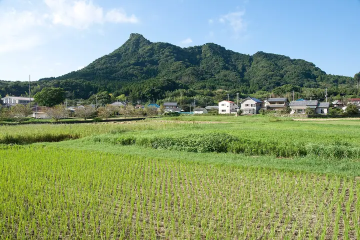
Mt. Iyogatake is a 336.3-meter peak in Minamiboso City, Chiba Prefecture, distinctive for being the only summit in the Boso Hills to bear the suffix "-take" and for its sharp rocky pinnacle that earns it the nickname "Matterhorn of Boso." The trail from Tenjinja Shrine climbs via rope- and chain-aided rock sections to a small summit crag with full 360-degree views. Together with neighbouring Mt. Tomisan it forms part of the local Tomiyama Sanzan, and it appears in many renowned lists including Nihon Hyaku Teizan and Kanto Hyakumeizan.
Mt. Iyogatake at a glance
- Weather: The most settled day in the next 7 days is Fri, November 6: clear, gusts up to 6 m/s. Thu, Nov 5: strong wind (gusts up to 15 m/s).
- Route: The shortest is Mount Iyogatake from Heguri Tenjin Shrine Circuit: about 2 h 11 min, 3.4 km, about 340 m of climbing.
Mt. Iyogatake weather (hourly, 14 days)
Sunrise today 06:03, sunset 16:45
| Tue, 11/3 | Wed, 11/4 | Thu, 11/5 | Fri, 11/6 | Sat, 11/7 | Sun, 11/8 | Mon, 11/9 | Tue, 11/10 | Wed, 11/11 | Thu, 11/12 | Fri, 11/13 | Sat, 11/14 | Sun, 11/15 | Mon, 11/16 | Tue, 11/17 | |||||||||||||||||||||||||||||||||||||||||||||||||||||||||||||||||||||||
|---|---|---|---|---|---|---|---|---|---|---|---|---|---|---|---|---|---|---|---|---|---|---|---|---|---|---|---|---|---|---|---|---|---|---|---|---|---|---|---|---|---|---|---|---|---|---|---|---|---|---|---|---|---|---|---|---|---|---|---|---|---|---|---|---|---|---|---|---|---|---|---|---|---|---|---|---|---|---|---|---|---|---|---|---|---|
| Japan time | 15 | 17 | 19 | 21 | 23 | 1 | 3 | 5 | 7 | 9 | 11 | 13 | 15 | 18 | 21 | 0 | 3 | 6 | 9 | 12 | 15 | 18 | 21 | 0 | 3 | 6 | 9 | 12 | 15 | 18 | 21 | 0 | 3 | 6 | 9 | 12 | 15 | 18 | 21 | 0 | 3 | 6 | 9 | 12 | 15 | 18 | 21 | 0 | 3 | 6 | 9 | 15 | 21 | 3 | 9 | 15 | 21 | 3 | 9 | 15 | 21 | 3 | 9 | 15 | 21 | 3 | 9 | 15 | 21 | 3 | 9 | 15 | 21 | 3 | 9 | 15 | 21 | 3 | 9 | 15 | 21 | 3 | 9 | 15 | |
  |   | | |   | | | |   | | | | | | | | | | | |   |   |   |   | | |  | | |  | | | | |   | |   | | | | | | | | | | | | | | | | | | |   | |   | | |   |  | | | | | | | | | | | | | | | | | | | | | | | ||
| Temperature | °C | 16° | 14° | 14° | 14° | 14° | 14° | 12° | 11° | 12° | 13° | 14° | 14° | 13° | 11° | 12° | 11° | 12° | 12° | 13° | 15° | 14° | 14° | 14° | 13° | 12° | 12° | 17° | 21° | 20° | 16° | 14° | 14° | 13° | 13° | 14° | 17° | 16° | 13° | 12° | 10° | 10° | 10° | 11° | 13° | 13° | 12° | 11° | 11° | 10° | 9° | 9° | 11° | 10° | 9° | 9° | 10° | 6° | 7° | 12° | 13° | 9° | 5° | 11° | 13° | 9° | 7° | 12° | 14° | 7° | 5° | 10° | 13° | 9° | 9° | 13° | 15° | 15° | 16° | 19° | 19° | 13° | 9° | 10° | 11° |
| Precipitation | mm | 0.3 | 0.1 | 0.4 | 0.6 | 0.2 | 0.4 | 2.2 | 3.9 | 8 | 9 | 12 | 3.6 | 0.4 | 4.0 | 11 | 7 | 0.6 | 0.4 | 0.2 | 1.2 | 0.4 | 0.5 | 0.7 | 3.0 | 4.1 | 2.4 | 1.2 | 0.4 | 1.6 | 2.9 | 24 | 9 | ||||||||||||||||||||||||||||||||||||||||||||||||||||
| New snow | cm | ||||||||||||||||||||||||||||||||||||||||||||||||||||||||||||||||||||||||||||||||||||
| Snow depth | cm | 0 | 0 | 0 | 0 | 0 | 0 | 0 | 0 | 0 | 0 | 0 | 0 | 0 | 0 | 0 | 0 | 0 | 0 | 0 | 0 | 0 | 0 | 0 | 0 | 0 | 0 | 0 | 0 | 0 | 0 | 0 | 0 | 0 | 0 | 0 | 0 | 0 | 0 | 0 | 0 | 0 | 0 | 0 | 0 | 0 | 0 | 0 | 0 | 0 | 0 | 0 | 0 | 0 | 0 | 0 | 0 | 0 | 0 | 0 | 0 | 0 | 0 | 0 | 0 | 0 | 0 | 0 | 0 | 0 | 0 | 0 | 0 | 0 | 0 | 0 | 0 | 0 | 0 | 0 | 0 | 0 | 0 | 0 | 0 |
| Wind | m/s | 2 | 2 | 2 | 3 | 3 | 4 | 4 | 5 | 5 | 5 | 5 | 5 | 6 | 5 | 4 | 5 | 5 | 6 | 6 | 6 | 2 | 2 | 2 | 2 | 1 | 0 | 1 | 0 | 2 | 2 | 1 | 2 | 2 | 3 | 3 | 3 | 2 | 2 | 4 | 4 | 4 | 4 | 3 | 2 | 2 | 3 | 2 | 3 | 4 | 5 | 4 | 5 | 5 | 5 | 5 | 4 | 3 | 2 | 7 | 7 | 5 | 3 | 3 | 2 | 3 | 2 | 3 | 5 | 5 | 4 | 4 | 1 | 2 | 2 | 0 | 4 | 6 | 7 | 6 | 4 | 5 | 4 | 4 | 4 |
| Wind gusts | m/s | 6 | 5 | 5 | 5 | 6 | 7 | 8 | 10 | 10 | 11 | 10 | 10 | 12 | 12 | 11 | 10 | 11 | 16 | 15 | 14 | 14 | 6 | 4 | 5 | 5 | 3 | 4 | 6 | 6 | 6 | 3 | 4 | 6 | 5 | 8 | 8 | 7 | 6 | 7 | 8 | 9 | 10 | 9 | 8 | 6 | 6 | 6 | 6 | 8 | 10 | 10 | 11 | 11 | 11 | 11 | 12 | 8 | 5 | 18 | 20 | 16 | 11 | 7 | 6 | 5 | 7 | 7 | 13 | 11 | 10 | 9 | 9 | 5 | 4 | 4 | 11 | 11 | 17 | 17 | 12 | 18 | 12 | 10 | 10 |
| Wind dir. | ↓ | ↓ | ↓ | ↓ | ↓ | ↓ | ↓ | ↓ | ↓ | ↓ | ↓ | ↓ | ↓ | ↓ | ↓ | ↓ | ↓ | ↓ | ↓ | ↓ | ↓ | ↓ | ↓ | ↓ | ↓ | ↓ | ↓ | ↓ | ↓ | ↓ | ↓ | ↓ | ↓ | ↓ | ↓ | ↓ | ↓ | ↓ | ↓ | ↓ | ↓ | ↓ | ↓ | ↓ | ↓ | ↓ | ↓ | ↓ | ↓ | ↓ | ↓ | ↓ | ↓ | ↓ | ↓ | ↓ | ↓ | ↓ | ↓ | ↓ | ↓ | ↓ | ↓ | ↓ | ↓ | ↓ | ↓ | ↓ | ↓ | ↓ | ↓ | ↓ | ↓ | ↓ | ↓ | ↓ | ↓ | ↓ | ↓ | ↓ | ↓ | ↓ | ↓ | ↓ | |
Mt. Iyogatake hiking routes
Hiking times are estimates calculated from the terrain.
Lists that include Mt. Iyogatake
100 Low Mountains of Japan · Kanto 100 Famous Mountains · Elevations of 1003 Mountains of Japan · 1000 Mountains of Japan
Mt. Iyogatake facts
- Also known as
- 伊予ヶ岳北峰
- Elevation
- 336 m
- Location
- Minamiboso, Chiba
35.107306, 139.913989 - Website
- www.mboso-etoko.jp
- Trail Map
- www.mboso-etoko.jp (PDF)
- Access Information
- www.city.minamiboso.chiba.jp
- Wikipedia
- ja.wikipedia.org