
Mt. Higashi-Mikabo
東御荷鉾山
Fujioka, Gunma / Kanna, Gunma · Elevation 1,246 m
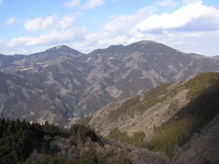
Higashi-Mikaboyama is a 1,246 m peak straddling Kanna Town and Fujioka City in southwestern Gunma — the eastern half of the twin Mikabo Peaks (the 1,287 m Nishi-Mikaboyama makes the western half), named for the Mikabo tectonic line that runs along the Kanna River valley below. It rises in a clean pyramidal shape, carries a statue of Fudō Myō-ō on the summit, and offers a sweeping panorama from the Kanto Plain to the Chichibu and Jōshin'etsu ranges. A short trail off the Mikabo Super Forest Road brings hikers to the top, and the peak is included in regional guidebooks such as Nishi-Jōshū no Yama 120 and the Gunma 300.
Mt. Higashi-Mikabo at a glance
- Weather: The most settled day in the next 7 days is Fri, November 6: clear, gusts up to 7 m/s. Sat, Nov 7: strong wind (gusts up to 15 m/s).
Mt. Higashi-Mikabo weather (hourly, 14 days)
Sunrise today 06:08, sunset 16:48
| Tue, 11/3 | Wed, 11/4 | Thu, 11/5 | Fri, 11/6 | Sat, 11/7 | Sun, 11/8 | Mon, 11/9 | Tue, 11/10 | Wed, 11/11 | Thu, 11/12 | Fri, 11/13 | Sat, 11/14 | Sun, 11/15 | Mon, 11/16 | Tue, 11/17 | |||||||||||||||||||||||||||||||||||||||||||||||||||||||||||||||||||||||
|---|---|---|---|---|---|---|---|---|---|---|---|---|---|---|---|---|---|---|---|---|---|---|---|---|---|---|---|---|---|---|---|---|---|---|---|---|---|---|---|---|---|---|---|---|---|---|---|---|---|---|---|---|---|---|---|---|---|---|---|---|---|---|---|---|---|---|---|---|---|---|---|---|---|---|---|---|---|---|---|---|---|---|---|---|---|
| Japan time | 21 | 23 | 1 | 3 | 5 | 7 | 9 | 11 | 13 | 15 | 17 | 19 | 21 | 0 | 3 | 6 | 9 | 12 | 15 | 18 | 21 | 0 | 3 | 6 | 9 | 12 | 15 | 18 | 21 | 0 | 3 | 6 | 9 | 12 | 15 | 18 | 21 | 0 | 3 | 6 | 9 | 12 | 15 | 18 | 21 | 0 | 3 | 6 | 9 | 12 | 15 | 21 | 3 | 9 | 15 | 21 | 3 | 9 | 15 | 21 | 3 | 9 | 15 | 21 | 3 | 9 | 15 | 21 | 3 | 9 | 15 | 21 | 3 | 9 | 15 | 21 | 3 | 9 | 15 | 21 | 3 | 9 | 15 | 21 | |
  |   |   | | |   | | |   | | |   | | | | |   |   | | | | | |   |  | | |  | | | | | | | | | | | | | | | | | | | | | | | | | |   | | | | | | |  | | | | | | | | | | | | | | | | | |   | |  | | | | ||
| Temperature | °C | 5° | 5° | 5° | 5° | 4° | 5° | 8° | 9° | 9° | 7° | 6° | 5° | 5° | 4° | 5° | 6° | 9° | 13° | 13° | 9° | 8° | 7° | 5° | 6° | 14° | 17° | 16° | 10° | 7° | 5° | 4° | 2° | 8° | 11° | 9° | 4° | 1° | 0° | -1° | -2° | 5° | 8° | 6° | 3° | 3° | 2° | 2° | 1° | 3° | 6° | 5° | 3° | 2° | 3° | 5° | 2° | 0° | 5° | 6° | 1° | -1° | 5° | 7° | 2° | -1° | 7° | 7° | 0° | -3° | 3° | 6° | 0° | -2° | 4° | 7° | 4° | 4° | 12° | 14° | 3° | -1° | 3° | 5° | 2° |
| Precipitation | mm | 0.4 | 1.0 | 6 | 9 | 7 | 1.2 | 0.2 | 3.0 | 0.7 | 1.4 | 6 | 0.2 | ||||||||||||||||||||||||||||||||||||||||||||||||||||||||||||||||||||||||
| New snow | cm | ||||||||||||||||||||||||||||||||||||||||||||||||||||||||||||||||||||||||||||||||||||
| Snow depth | cm | 0 | 0 | 0 | 0 | 0 | 0 | 0 | 0 | 0 | 0 | 0 | 0 | 0 | 0 | 0 | 0 | 0 | 0 | 0 | 0 | 0 | 0 | 0 | 0 | 0 | 0 | 0 | 0 | 0 | 0 | 0 | 0 | 0 | 0 | 0 | 0 | 0 | 0 | 0 | 0 | 0 | 0 | 0 | 0 | 0 | 0 | 0 | 0 | 0 | 0 | 0 | 0 | 0 | 0 | 0 | 0 | 0 | 0 | 0 | 0 | 0 | 0 | 0 | 0 | 0 | 0 | 0 | 0 | 0 | 0 | 0 | 0 | 0 | 0 | 0 | 0 | 0 | 0 | 0 | 0 | 0 | 0 | 0 | 0 |
| Wind | m/s | 1 | 0 | 0 | 1 | 1 | 1 | 1 | 2 | 3 | 2 | 1 | 0 | 0 | 2 | 2 | 1 | 2 | 1 | 1 | 1 | 1 | 1 | 1 | 3 | 2 | 2 | 2 | 0 | 3 | 3 | 3 | 3 | 3 | 5 | 5 | 2 | 2 | 3 | 3 | 3 | 2 | 3 | 2 | 0 | 0 | 0 | 1 | 1 | 0 | 1 | 1 | 0 | 1 | 2 | 2 | 0 | 2 | 7 | 6 | 3 | 3 | 1 | 2 | 1 | 1 | 3 | 3 | 3 | 2 | 1 | 2 | 1 | 1 | 0 | 0 | 2 | 1 | 2 | 3 | 3 | 2 | 1 | 2 | 1 |
| Wind gusts | m/s | 3 | 2 | 2 | 3 | 3 | 3 | 4 | 7 | 8 | 7 | 6 | 4 | 3 | 5 | 6 | 5 | 5 | 5 | 4 | 4 | 3 | 4 | 5 | 7 | 7 | 7 | 7 | 6 | 7 | 8 | 8 | 8 | 9 | 14 | 15 | 12 | 7 | 8 | 8 | 7 | 8 | 8 | 8 | 5 | 2 | 2 | 4 | 4 | 4 | 5 | 5 | 5 | 4 | 5 | 7 | 6 | 6 | 21 | 19 | 15 | 7 | 6 | 6 | 5 | 4 | 8 | 12 | 9 | 8 | 6 | 6 | 5 | 3 | 4 | 5 | 5 | 5 | 6 | 11 | 12 | 11 | 5 | 6 | 6 |
| Wind dir. | ↓ | ↓ | ↓ | ↓ | ↓ | ↓ | ↓ | ↓ | ↓ | ↓ | ↓ | ↓ | ↓ | ↓ | ↓ | ↓ | ↓ | ↓ | ↓ | ↓ | ↓ | ↓ | ↓ | ↓ | ↓ | ↓ | ↓ | ↓ | ↓ | ↓ | ↓ | ↓ | ↓ | ↓ | ↓ | ↓ | ↓ | ↓ | ↓ | ↓ | ↓ | ↓ | ↓ | ↓ | ↓ | ↓ | ↓ | ↓ | ↓ | ↓ | ↓ | ↓ | ↓ | ↓ | ↓ | ↓ | ↓ | ↓ | ↓ | ↓ | ↓ | ↓ | ↓ | ↓ | ↓ | ↓ | ↓ | ↓ | ↓ | ↓ | ↓ | ↓ | ↓ | ↓ | ↓ | ↓ | ↓ | ↓ | ↓ | ↓ | ↓ | ↓ | ↓ | ↓ | |
Huts, campsites and lodging near Mt. Higashi-Mikabo
Lodging
- みかぼ高原荘
Mt. Higashi-Mikabo facts
- Elevation
- 1,246 m
- Location
- Fujioka, Gunma / Kanna, Gunma
36.149155, 138.941442 - Website
- www.town.kanna.gunma.jp (PDF)
- Wikipedia
- ja.wikipedia.org