
Mt. Jominesan
城峯山
Kamikawa, Saitama / Minano, Saitama / Chichibu, Saitama · Elevation 1,038 m
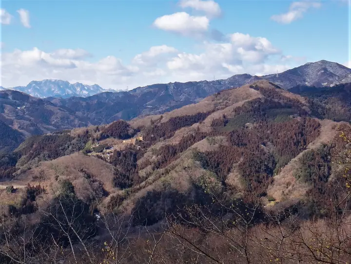
Mount Jominesan (1,037.7 m) is an isolated peak on the northern edge of the Chichibu Mountains, on the border of Kamikawa Town (Kodama District) and Minano Town (Chichibu District) in Saitama. Jōmine Shrine on its flank ties the mountain to a legend of Yamato Takeru's eastern campaign, and an observation tower at the summit commands sweeping views from Mount Ryōkami and Mount Bukō to Mount Akagi and Mount Asama. A section of the Kanto Fureai-no-michi (Metropolitan Nature Trail) crosses the mountain, and it is included in numerous lists including the Kanto 100 and Japan 100 Low Mountains.
Mt. Jominesan at a glance
- Weather: The most settled day in the next 7 days is Fri, November 6: clear, gusts up to 7 m/s.
Mt. Jominesan weather (hourly, 14 days)
Sunrise today 06:08, sunset 16:47
| Tue, 11/3 | Wed, 11/4 | Thu, 11/5 | Fri, 11/6 | Sat, 11/7 | Sun, 11/8 | Mon, 11/9 | Tue, 11/10 | Wed, 11/11 | Thu, 11/12 | Fri, 11/13 | Sat, 11/14 | Sun, 11/15 | Mon, 11/16 | Tue, 11/17 | |||||||||||||||||||||||||||||||||||||||||||||||||||||||||||||||||||||||
|---|---|---|---|---|---|---|---|---|---|---|---|---|---|---|---|---|---|---|---|---|---|---|---|---|---|---|---|---|---|---|---|---|---|---|---|---|---|---|---|---|---|---|---|---|---|---|---|---|---|---|---|---|---|---|---|---|---|---|---|---|---|---|---|---|---|---|---|---|---|---|---|---|---|---|---|---|---|---|---|---|---|---|---|---|---|
| Japan time | 15 | 17 | 19 | 21 | 23 | 1 | 3 | 5 | 7 | 9 | 11 | 13 | 15 | 18 | 21 | 0 | 3 | 6 | 9 | 12 | 15 | 18 | 21 | 0 | 3 | 6 | 9 | 12 | 15 | 18 | 21 | 0 | 3 | 6 | 9 | 12 | 15 | 18 | 21 | 0 | 3 | 6 | 9 | 12 | 15 | 18 | 21 | 0 | 3 | 6 | 9 | 15 | 21 | 3 | 9 | 15 | 21 | 3 | 9 | 15 | 21 | 3 | 9 | 15 | 21 | 3 | 9 | 15 | 21 | 3 | 9 | 15 | 21 | 3 | 9 | 15 | 21 | 3 | 9 | 15 | 21 | 3 | 9 | 15 | |
  |   |   | | |   | | |   | |   | | | | | | | |   | |   |   | | |  | |  | | | | | | | | | | | | | | | | | | | | |   | | | | | | | | | | | | |   |  | | | | | | | | | | | | | | | |   | | | | | | | ||
| Temperature | °C | 11° | 7° | 7° | 7° | 6° | 6° | 5° | 5° | 6° | 8° | 9° | 8° | 7° | 5° | 5° | 5° | 5° | 5° | 8° | 14° | 10° | 8° | 7° | 6° | 5° | 6° | 13° | 17° | 16° | 10° | 7° | 5° | 4° | 2° | 8° | 11° | 9° | 3° | 1° | -1° | -1° | -2° | 5° | 8° | 7° | 3° | 3° | 2° | 1° | 1° | 4° | 6° | 3° | 2° | 3° | 6° | 2° | 0° | 6° | 7° | 1° | -3° | 5° | 7° | 3° | -1° | 8° | 7° | 0° | -4° | 3° | 6° | -1° | -2° | 4° | 6° | 4° | 4° | 11° | 13° | 4° | 0° | 3° | 5° |
| Precipitation | mm | 0.2 | 0.3 | 0.3 | 3.7 | 10 | 12 | 1.3 | 1.3 | 0.3 | 0.2 | 2.0 | 0.4 | 2.2 | 10 | ||||||||||||||||||||||||||||||||||||||||||||||||||||||||||||||||||||||
| New snow | cm | ||||||||||||||||||||||||||||||||||||||||||||||||||||||||||||||||||||||||||||||||||||
| Snow depth | cm | 0 | 0 | 0 | 0 | 0 | 0 | 0 | 0 | 0 | 0 | 0 | 0 | 0 | 0 | 0 | 0 | 0 | 0 | 0 | 0 | 0 | 0 | 0 | 0 | 0 | 0 | 0 | 0 | 0 | 0 | 0 | 0 | 0 | 0 | 0 | 0 | 0 | 0 | 0 | 0 | 0 | 0 | 0 | 0 | 0 | 0 | 0 | 0 | 0 | 0 | 0 | 0 | 0 | 0 | 0 | 0 | 0 | 0 | 0 | 0 | 0 | 0 | 0 | 0 | 0 | 0 | 0 | 0 | 0 | 0 | 0 | 0 | 0 | 0 | 0 | 0 | 0 | 0 | 0 | 0 | 0 | 0 | 0 | 0 |
| Wind | m/s | 2 | 1 | 1 | 0 | 1 | 0 | 1 | 1 | 0 | 1 | 2 | 2 | 2 | 1 | 1 | 1 | 1 | 1 | 2 | 1 | 1 | 1 | 1 | 1 | 1 | 1 | 1 | 2 | 2 | 1 | 1 | 2 | 2 | 2 | 3 | 5 | 4 | 0 | 1 | 1 | 1 | 1 | 2 | 2 | 2 | 1 | 1 | 0 | 1 | 0 | 1 | 1 | 0 | 1 | 2 | 2 | 1 | 2 | 7 | 6 | 2 | 2 | 1 | 2 | 1 | 1 | 3 | 4 | 2 | 1 | 1 | 2 | 1 | 1 | 1 | 1 | 1 | 1 | 1 | 3 | 3 | 1 | 1 | 2 |
| Wind gusts | m/s | 6 | 5 | 3 | 2 | 1 | 1 | 2 | 2 | 2 | 5 | 6 | 6 | 6 | 5 | 3 | 3 | 4 | 5 | 5 | 6 | 4 | 3 | 3 | 4 | 3 | 3 | 4 | 6 | 7 | 5 | 4 | 6 | 7 | 7 | 8 | 12 | 12 | 10 | 3 | 4 | 4 | 4 | 5 | 6 | 7 | 7 | 3 | 2 | 3 | 2 | 4 | 6 | 4 | 4 | 5 | 8 | 7 | 5 | 19 | 18 | 14 | 6 | 5 | 7 | 5 | 3 | 8 | 12 | 9 | 6 | 5 | 7 | 5 | 3 | 3 | 6 | 4 | 4 | 5 | 11 | 10 | 9 | 4 | 6 |
| Wind dir. | ↓ | ↓ | ↓ | ↓ | ↓ | ↓ | ↓ | ↓ | ↓ | ↓ | ↓ | ↓ | ↓ | ↓ | ↓ | ↓ | ↓ | ↓ | ↓ | ↓ | ↓ | ↓ | ↓ | ↓ | ↓ | ↓ | ↓ | ↓ | ↓ | ↓ | ↓ | ↓ | ↓ | ↓ | ↓ | ↓ | ↓ | ↓ | ↓ | ↓ | ↓ | ↓ | ↓ | ↓ | ↓ | ↓ | ↓ | ↓ | ↓ | ↓ | ↓ | ↓ | ↓ | ↓ | ↓ | ↓ | ↓ | ↓ | ↓ | ↓ | ↓ | ↓ | ↓ | ↓ | ↓ | ↓ | ↓ | ↓ | ↓ | ↓ | ↓ | ↓ | ↓ | ↓ | ↓ | ↓ | ↓ | ↓ | ↓ | ↓ | ↓ | ↓ | ↓ | ||
Huts, campsites and lodging near Mt. Jominesan
Campsites
- 城峯山キャンプ場
- 城峯公園キャンプ場
Lists that include Mt. Jominesan
100 Low Mountains of Japan · Kanto 100 Famous Mountains · 50 Mountains of Saitama Prefecture · 1000 Mountains of Japan
Mt. Jominesan facts
- Elevation
- 1,038 m
- Location
- Kamikawa, Saitama / Minano, Saitama / Chichibu, Saitama
36.097591, 139.007649 - Website
- www.town.kamikawa.saitama.jp
- Trail Map
- www.town.kamikawa.saitama.jp (PDF)
- Wikipedia
- ja.wikipedia.org