
Mt. Hodosan
宝登山
Nagatoro, Saitama · Elevation 497 m
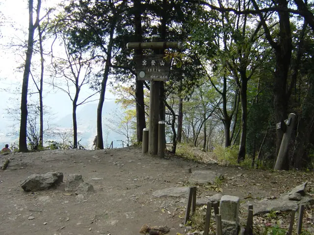
Mt. Hodosan (497 m) rises in Nagatoro Town, Chichibu, Saitama, at the southern end of the Chichibu Range, with the inner shrine of Hodosan-jinja just below the summit—the mountain has long been revered as a sacred site. A 5-minute ropeway connects the lower and summit stations, and the gardens at the top draw visitors year-round: rōbai (wintersweet) from late December to late February, plum blossoms from early February to late March, and cherries in April. From the summit hikers look across to Mt. Bukō, Mt. Ryōkami, and the Chichibu basin, and the peak is also walked as part of the Nagatoro Alps ridge route. It is counted among the 100 Hikes of Kantō and the 100 Famous Mountains of Kantō (2019).
Mt. Hodosan at a glance
- Weather: The most settled day in the next 7 days is Fri, November 6: clear, gusts up to 7 m/s.
- Route: The shortest is Nagatoro Alps and Mount Hodosan Traverse from Nogami to Nagatoro: about 3 h 54 min, 8.8 km, about 430 m of climbing.
Mt. Hodosan weather (hourly, 14 days)
Sunrise today 06:07, sunset 16:47
| Tue, 11/3 | Wed, 11/4 | Thu, 11/5 | Fri, 11/6 | Sat, 11/7 | Sun, 11/8 | Mon, 11/9 | Tue, 11/10 | Wed, 11/11 | Thu, 11/12 | Fri, 11/13 | Sat, 11/14 | Sun, 11/15 | Mon, 11/16 | Tue, 11/17 | |||||||||||||||||||||||||||||||||||||||||||||||||||||||||||||||||||||||
|---|---|---|---|---|---|---|---|---|---|---|---|---|---|---|---|---|---|---|---|---|---|---|---|---|---|---|---|---|---|---|---|---|---|---|---|---|---|---|---|---|---|---|---|---|---|---|---|---|---|---|---|---|---|---|---|---|---|---|---|---|---|---|---|---|---|---|---|---|---|---|---|---|---|---|---|---|---|---|---|---|---|---|---|---|---|
| Japan time | 15 | 17 | 19 | 21 | 23 | 1 | 3 | 5 | 7 | 9 | 11 | 13 | 15 | 18 | 21 | 0 | 3 | 6 | 9 | 12 | 15 | 18 | 21 | 0 | 3 | 6 | 9 | 12 | 15 | 18 | 21 | 0 | 3 | 6 | 9 | 12 | 15 | 18 | 21 | 0 | 3 | 6 | 9 | 12 | 15 | 18 | 21 | 0 | 3 | 6 | 9 | 15 | 21 | 3 | 9 | 15 | 21 | 3 | 9 | 15 | 21 | 3 | 9 | 15 | 21 | 3 | 9 | 15 | 21 | 3 | 9 | 15 | 21 | 3 | 9 | 15 | 21 | 3 | 9 | 15 | 21 | 3 | 9 | 15 | |
  |   |   | | |   | | |   | |   | | | | | | | |   | |   |   | | |  | |  | | | | | | | | | | | | | | | | | | | | |   | | | | | | | | | | | | |   |  | | | | | | | | | | | | | | | |   | | | | | | | ||
| Temperature | °C | 14° | 11° | 11° | 11° | 10° | 9° | 9° | 8° | 9° | 11° | 12° | 12° | 11° | 9° | 8° | 8° | 9° | 9° | 12° | 17° | 14° | 12° | 10° | 10° | 9° | 9° | 16° | 20° | 19° | 13° | 10° | 8° | 7° | 6° | 12° | 14° | 12° | 6° | 4° | 3° | 2° | 2° | 8° | 12° | 11° | 6° | 7° | 6° | 5° | 5° | 7° | 9° | 7° | 5° | 7° | 9° | 5° | 3° | 9° | 10° | 4° | 1° | 9° | 10° | 6° | 2° | 12° | 11° | 3° | 0° | 6° | 9° | 2° | 2° | 8° | 10° | 7° | 7° | 15° | 17° | 8° | 3° | 6° | 9° |
| Precipitation | mm | 0.2 | 0.3 | 0.3 | 3.7 | 10 | 12 | 1.3 | 1.3 | 0.3 | 0.2 | 2.0 | 0.4 | 2.2 | 10 | ||||||||||||||||||||||||||||||||||||||||||||||||||||||||||||||||||||||
| New snow | cm | ||||||||||||||||||||||||||||||||||||||||||||||||||||||||||||||||||||||||||||||||||||
| Snow depth | cm | 0 | 0 | 0 | 0 | 0 | 0 | 0 | 0 | 0 | 0 | 0 | 0 | 0 | 0 | 0 | 0 | 0 | 0 | 0 | 0 | 0 | 0 | 0 | 0 | 0 | 0 | 0 | 0 | 0 | 0 | 0 | 0 | 0 | 0 | 0 | 0 | 0 | 0 | 0 | 0 | 0 | 0 | 0 | 0 | 0 | 0 | 0 | 0 | 0 | 0 | 0 | 0 | 0 | 0 | 0 | 0 | 0 | 0 | 0 | 0 | 0 | 0 | 0 | 0 | 0 | 0 | 0 | 0 | 0 | 0 | 0 | 0 | 0 | 0 | 0 | 0 | 0 | 0 | 0 | 0 | 0 | 0 | 0 | 0 |
| Wind | m/s | 2 | 1 | 1 | 0 | 1 | 0 | 1 | 1 | 0 | 1 | 2 | 2 | 2 | 1 | 1 | 1 | 1 | 1 | 2 | 1 | 1 | 1 | 1 | 1 | 1 | 1 | 1 | 2 | 2 | 1 | 1 | 2 | 2 | 2 | 3 | 5 | 4 | 0 | 1 | 1 | 1 | 1 | 2 | 2 | 2 | 1 | 1 | 0 | 1 | 0 | 1 | 1 | 0 | 1 | 2 | 2 | 1 | 2 | 7 | 6 | 2 | 2 | 1 | 2 | 1 | 1 | 3 | 4 | 2 | 1 | 1 | 2 | 1 | 1 | 1 | 1 | 1 | 1 | 1 | 3 | 3 | 1 | 1 | 2 |
| Wind gusts | m/s | 6 | 5 | 3 | 2 | 1 | 1 | 2 | 2 | 2 | 5 | 6 | 6 | 6 | 5 | 3 | 3 | 4 | 5 | 5 | 6 | 4 | 3 | 3 | 4 | 3 | 3 | 4 | 6 | 7 | 5 | 4 | 6 | 7 | 7 | 8 | 12 | 12 | 10 | 3 | 4 | 4 | 4 | 5 | 6 | 7 | 7 | 3 | 2 | 3 | 2 | 4 | 6 | 4 | 4 | 5 | 8 | 7 | 5 | 19 | 18 | 14 | 6 | 5 | 7 | 5 | 3 | 8 | 12 | 9 | 6 | 5 | 7 | 5 | 3 | 3 | 6 | 4 | 4 | 5 | 11 | 10 | 9 | 4 | 6 |
| Wind dir. | ↓ | ↓ | ↓ | ↓ | ↓ | ↓ | ↓ | ↓ | ↓ | ↓ | ↓ | ↓ | ↓ | ↓ | ↓ | ↓ | ↓ | ↓ | ↓ | ↓ | ↓ | ↓ | ↓ | ↓ | ↓ | ↓ | ↓ | ↓ | ↓ | ↓ | ↓ | ↓ | ↓ | ↓ | ↓ | ↓ | ↓ | ↓ | ↓ | ↓ | ↓ | ↓ | ↓ | ↓ | ↓ | ↓ | ↓ | ↓ | ↓ | ↓ | ↓ | ↓ | ↓ | ↓ | ↓ | ↓ | ↓ | ↓ | ↓ | ↓ | ↓ | ↓ | ↓ | ↓ | ↓ | ↓ | ↓ | ↓ | ↓ | ↓ | ↓ | ↓ | ↓ | ↓ | ↓ | ↓ | ↓ | ↓ | ↓ | ↓ | ↓ | ↓ | ↓ | ||
Mt. Hodosan hiking routes
Hiking times are estimates calculated from the terrain.
Huts, campsites and lodging near Mt. Hodosan
Campsites
- WATER PARK NAGATORO
- 満願ビレッジオートキャンプ場
- 長瀞オートキャンプ場
- Forest Sons Nagatoro
Lodging
- 民宿 やなぎや
- いこいの村ヘリテイジ美の山
Lists that include Mt. Hodosan
Mt. Hodosan facts
- Elevation
- 497 m
- Location
- Nagatoro, Saitama
36.093131, 139.091624 - Website
- www.nagatoro.gr.jp
- Trail Map
- www.nagatoro.gr.jp (PDF)
- Access Information
- www.hodosan-ropeway.co.jp
- Wikipedia
- ja.wikipedia.org