
Futagoyama East Peak
二子山東岳
Ogano, Saitama · Elevation 1,122 m
The East Peak of Futagoyama, at 1,122 meters, is one of the twin limestone summits in Ogano, Chichibu District, Saitama Prefecture, paired with the West Peak (about 1,166 m). Its sheer rock ridges rank among the most difficult routes in Saitama and are known to advanced climbers, while the mountain is also a rock-climbing mecca developed by pro climber Yuji Hirayama and others. The Mata-toge saddle between the peaks is noted for dogtooth violets and anemones. It is counted among the 350 Mountains around Tokyo and the 120 Mountains of West Joshu.
Futagoyama East Peak at a glance
- Weather: The most settled day in the next 7 days is Fri, November 6: clear, gusts up to 7 m/s.
- Route: The shortest is Futagoyama East and West Peaks Loop from Kurao Trailhead: about 2 h 5 min, 2.9 km, about 450 m of climbing.
Futagoyama East Peak weather (hourly, 14 days)
Sunrise today 06:08, sunset 16:48
| Tue, 11/3 | Wed, 11/4 | Thu, 11/5 | Fri, 11/6 | Sat, 11/7 | Sun, 11/8 | Mon, 11/9 | Tue, 11/10 | Wed, 11/11 | Thu, 11/12 | Fri, 11/13 | Sat, 11/14 | Sun, 11/15 | Mon, 11/16 | Tue, 11/17 | |||||||||||||||||||||||||||||||||||||||||||||||||||||||||||||||||||||||
|---|---|---|---|---|---|---|---|---|---|---|---|---|---|---|---|---|---|---|---|---|---|---|---|---|---|---|---|---|---|---|---|---|---|---|---|---|---|---|---|---|---|---|---|---|---|---|---|---|---|---|---|---|---|---|---|---|---|---|---|---|---|---|---|---|---|---|---|---|---|---|---|---|---|---|---|---|---|---|---|---|---|---|---|---|---|
| Japan time | 15 | 17 | 19 | 21 | 23 | 1 | 3 | 5 | 7 | 9 | 11 | 13 | 15 | 18 | 21 | 0 | 3 | 6 | 9 | 12 | 15 | 18 | 21 | 0 | 3 | 6 | 9 | 12 | 15 | 18 | 21 | 0 | 3 | 6 | 9 | 12 | 15 | 18 | 21 | 0 | 3 | 6 | 9 | 12 | 15 | 18 | 21 | 0 | 3 | 6 | 9 | 15 | 21 | 3 | 9 | 15 | 21 | 3 | 9 | 15 | 21 | 3 | 9 | 15 | 21 | 3 | 9 | 15 | 21 | 3 | 9 | 15 | 21 | 3 | 9 | 15 | 21 | 3 | 9 | 15 | 21 | 3 | 9 | 15 | |
  |   |   |   | | | | |   | | | |   |   | | | | | | |   | | |  | | |  | | | |   | | | | | | | | | | | |   | | | | | | | | | | | | | | | |   | |   |  | | | | | | | | | | | | | | | | | | | |  | | | ||
| Temperature | °C | 11° | 7° | 7° | 7° | 7° | 6° | 6° | 5° | 6° | 9° | 10° | 9° | 7° | 5° | 5° | 5° | 6° | 8° | 10° | 15° | 12° | 9° | 9° | 7° | 7° | 8° | 14° | 19° | 17° | 11° | 7° | 5° | 3° | 2° | 10° | 12° | 9° | 3° | 0° | -1° | -1° | -2° | 7° | 10° | 8° | 4° | 4° | 4° | 3° | 3° | 6° | 7° | 5° | 3° | 4° | 5° | 3° | 0° | 5° | 5° | 0° | -3° | 6° | 7° | 3° | -1° | 8° | 7° | -1° | -2° | 5° | 6° | 0° | 0° | 7° | 9° | 6° | 7° | 14° | 13° | 5° | 1° | 5° | 5° |
| Precipitation | mm | 0.1 | 0.3 | 0.4 | 3.8 | 9 | 6 | 0.5 | 2.1 | 0.3 | 0.1 | 0.1 | 0.3 | 4.6 | 2.2 | 0.4 | 0.2 | 2.7 | 8 | ||||||||||||||||||||||||||||||||||||||||||||||||||||||||||||||||||
| New snow | cm | ||||||||||||||||||||||||||||||||||||||||||||||||||||||||||||||||||||||||||||||||||||
| Snow depth | cm | 0 | 0 | 0 | 0 | 0 | 0 | 0 | 0 | 0 | 0 | 0 | 0 | 0 | 0 | 0 | 0 | 0 | 0 | 0 | 0 | 0 | 0 | 0 | 0 | 0 | 0 | 0 | 0 | 0 | 0 | 0 | 0 | 0 | 0 | 0 | 0 | 0 | 0 | 0 | 0 | 0 | 0 | 0 | 0 | 0 | 0 | 0 | 0 | 0 | 0 | 0 | 0 | 0 | 0 | 0 | 0 | 0 | 0 | 0 | 0 | 0 | 0 | 0 | 0 | 0 | 0 | 0 | 0 | 0 | 0 | 0 | 0 | 0 | 0 | 0 | 0 | 0 | 0 | 0 | 0 | 0 | 0 | 0 | 0 |
| Wind | m/s | 2 | 1 | 0 | 0 | 1 | 1 | 1 | 1 | 1 | 2 | 3 | 3 | 2 | 2 | 1 | 0 | 1 | 1 | 1 | 2 | 1 | 0 | 1 | 0 | 0 | 1 | 1 | 2 | 2 | 0 | 2 | 3 | 3 | 2 | 3 | 4 | 4 | 0 | 2 | 2 | 2 | 1 | 2 | 2 | 2 | 0 | 1 | 1 | 1 | 1 | 2 | 1 | 1 | 1 | 2 | 3 | 1 | 2 | 8 | 7 | 2 | 2 | 1 | 2 | 1 | 1 | 5 | 5 | 2 | 2 | 2 | 2 | 0 | 0 | 1 | 1 | 1 | 0 | 1 | 5 | 5 | 1 | 2 | 2 |
| Wind gusts | m/s | 8 | 6 | 2 | 2 | 2 | 3 | 2 | 2 | 2 | 6 | 8 | 9 | 8 | 6 | 5 | 3 | 3 | 3 | 4 | 6 | 5 | 5 | 2 | 3 | 3 | 3 | 5 | 7 | 7 | 7 | 5 | 8 | 8 | 9 | 8 | 11 | 12 | 10 | 5 | 5 | 6 | 6 | 6 | 8 | 8 | 7 | 2 | 3 | 3 | 2 | 5 | 8 | 4 | 4 | 7 | 10 | 8 | 6 | 25 | 22 | 18 | 7 | 6 | 9 | 7 | 4 | 12 | 16 | 13 | 7 | 5 | 8 | 6 | 2 | 3 | 7 | 4 | 4 | 4 | 15 | 15 | 14 | 6 | 8 |
| Wind dir. | ↓ | ↓ | ↓ | ↓ | ↓ | ↓ | ↓ | ↓ | ↓ | ↓ | ↓ | ↓ | ↓ | ↓ | ↓ | ↓ | ↓ | ↓ | ↓ | ↓ | ↓ | ↓ | ↓ | ↓ | ↓ | ↓ | ↓ | ↓ | ↓ | ↓ | ↓ | ↓ | ↓ | ↓ | ↓ | ↓ | ↓ | ↓ | ↓ | ↓ | ↓ | ↓ | ↓ | ↓ | ↓ | ↓ | ↓ | ↓ | ↓ | ↓ | ↓ | ↓ | ↓ | ↓ | ↓ | ↓ | ↓ | ↓ | ↓ | ↓ | ↓ | ↓ | ↓ | ↓ | ↓ | ↓ | ↓ | ↓ | ↓ | ↓ | ↓ | ↓ | ↓ | ↓ | ↓ | ↓ | ↓ | ↓ | ↓ | ↓ | ↓ | ↓ | ↓ | ↓ | |
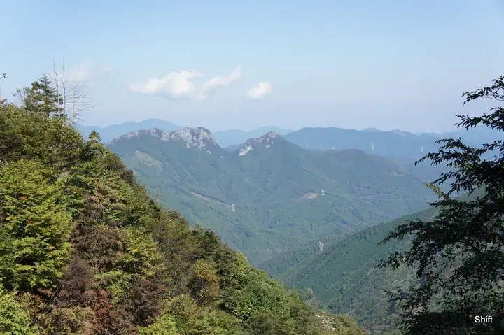
Futagoyama East Peak hiking routes
Hiking times are estimates calculated from the terrain.
Huts, campsites and lodging near Futagoyama East Peak
Lodging
- 両神山荘
Futagoyama East Peak facts
- Elevation
- 1,122 m
- Location
- Ogano, Saitama
36.067296, 138.869526 - Website
- kanko-ogano.jp
- Wikipedia
- ja.wikipedia.org