
Mt. Heko
部子山
Ōno-shi, Fukui / Ikeda, Fukui · Elevation 1,464 m
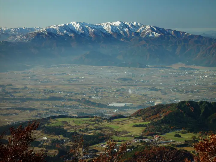
A 1,464 m peak on the border of Ikeda Town and Ōno City in Fukui, and the highest summit of Ikeda. The mountain takes its name from a small shrine at the top dedicated to Megako, consort of Emperor Keitai—"Megako-no-take" eventually contracting into "Hekosan." It rises at the head of the Heko and Mana rivers in the Kuzuryū basin and is sometimes counted among the Echizen Five Sacred Peaks opened by the Buddhist monk Taichō. A forest road climbs to within 4.6 km of the summit, leaving about 80 minutes of walking, but the road is closed by snow from late November until early June each year. The peak appears in Nihon no Yama 1000 and Hokuriku Hyakuzan, among other lists.
Mt. Heko at a glance
- Weather: The most settled day in the next 7 days is Wed, November 4: clear, gusts up to 5 m/s. Sat, Nov 7: strong wind (gusts up to 17 m/s).
Mt. Heko weather (hourly, 14 days)
Sunrise today 06:18, sunset 16:58
| Tue, 11/3 | Wed, 11/4 | Thu, 11/5 | Fri, 11/6 | Sat, 11/7 | Sun, 11/8 | Mon, 11/9 | Tue, 11/10 | Wed, 11/11 | Thu, 11/12 | Fri, 11/13 | Sat, 11/14 | Sun, 11/15 | Mon, 11/16 | Tue, 11/17 | |||||||||||||||||||||||||||||||||||||||||||||||||||||||||||||||||||||||
|---|---|---|---|---|---|---|---|---|---|---|---|---|---|---|---|---|---|---|---|---|---|---|---|---|---|---|---|---|---|---|---|---|---|---|---|---|---|---|---|---|---|---|---|---|---|---|---|---|---|---|---|---|---|---|---|---|---|---|---|---|---|---|---|---|---|---|---|---|---|---|---|---|---|---|---|---|---|---|---|---|---|---|---|---|---|
| Japan time | 15 | 17 | 19 | 21 | 23 | 1 | 3 | 5 | 7 | 9 | 11 | 13 | 15 | 18 | 21 | 0 | 3 | 6 | 9 | 12 | 15 | 18 | 21 | 0 | 3 | 6 | 9 | 12 | 15 | 18 | 21 | 0 | 3 | 6 | 9 | 12 | 15 | 18 | 21 | 0 | 3 | 6 | 9 | 12 | 15 | 18 | 21 | 0 | 3 | 6 | 9 | 15 | 21 | 3 | 9 | 15 | 21 | 3 | 9 | 15 | 21 | 3 | 9 | 15 | 21 | 3 | 9 | 15 | 21 | 3 | 9 | 15 | 21 | 3 | 9 | 15 | 21 | 3 | 9 | 15 | 21 | 3 | 9 | 15 | |
 |  | |   | | | | |   | | | |   |   | |   | | |   | | |   |   | | | |   |   | | | | | | | | | | | | | | | | | |   | | | | | | | | | | | | | | | |  | | | | | | | | | | | | |   | | | | | | | | | | ||
| Temperature | °C | 10° | 6° | 4° | 3° | 3° | 3° | 2° | 2° | 3° | 9° | 12° | 13° | 12° | 8° | 8° | 7° | 8° | 7° | 9° | 13° | 13° | 10° | 9° | 9° | 8° | 8° | 8° | 11° | 7° | 5° | 4° | 2° | 1° | 1° | 1° | 4° | 3° | 1° | 0° | 0° | 1° | 1° | 4° | 5° | 5° | 2° | 2° | 2° | 3° | 3° | 6° | 7° | 2° | 1° | 6° | 6° | 3° | -1° | 2° | 3° | 0° | -2° | 3° | 5° | 1° | 3° | 3° | 4° | -1° | -2° | 7° | 9° | 5° | 5° | 6° | 8° | 8° | 8° | 8° | 6° | 1° | -1° | 2° | 5° |
| Precipitation | mm | 2.6 | 6 | 2.6 | 2.5 | 0.1 | 0.4 | 1.3 | 0.9 | 12 | 2.1 | 2.5 | 1.7 | 1.5 | 1.2 | 1.0 | 1.0 | 1.6 | 1.5 | 1.3 | 0.6 | 0.1 | 0.2 | 0.4 | 0.1 | 0.5 | 0.3 | 0.7 | 9 | 5 | 0.3 | 0.9 | 2.4 | 1.1 | 0.2 | 0.2 | 6 | 8 | 4.1 | 3.5 | 0.8 | ||||||||||||||||||||||||||||||||||||||||||||
| New snow | cm | ||||||||||||||||||||||||||||||||||||||||||||||||||||||||||||||||||||||||||||||||||||
| Snow depth | cm | 0 | 0 | 0 | 0 | 0 | 0 | 0 | 0 | 0 | 0 | 0 | 0 | 0 | 0 | 0 | 0 | 0 | 0 | 0 | 0 | 0 | 0 | 0 | 0 | 0 | 0 | 0 | 0 | 0 | 0 | 0 | 0 | 0 | 0 | 0 | 0 | 0 | 0 | 0 | 0 | 0 | 0 | 0 | 0 | 0 | 0 | 0 | 0 | 0 | 0 | 0 | 0 | 0 | 0 | 0 | 0 | 0 | 0 | 0 | 0 | 0 | 0 | 0 | 0 | 0 | 0 | 0 | 0 | 0 | 0 | 0 | 0 | 0 | 0 | 0 | 0 | 0 | 0 | 0 | 0 | 0 | 0 | 0 | 0 |
| Wind | m/s | 4 | 1 | 1 | 1 | 1 | 1 | 1 | 0 | 0 | 0 | 0 | 0 | 1 | 1 | 2 | 0 | 2 | 1 | 2 | 0 | 2 | 0 | 2 | 2 | 1 | 2 | 4 | 5 | 4 | 4 | 4 | 4 | 4 | 4 | 5 | 6 | 6 | 4 | 4 | 4 | 3 | 3 | 3 | 4 | 3 | 1 | 1 | 0 | 0 | 0 | 2 | 3 | 0 | 2 | 3 | 3 | 3 | 5 | 6 | 6 | 3 | 1 | 1 | 3 | 1 | 1 | 5 | 6 | 2 | 0 | 2 | 2 | 3 | 4 | 4 | 5 | 5 | 2 | 4 | 6 | 3 | 1 | 1 | 2 |
| Wind gusts | m/s | 10 | 10 | 4 | 3 | 3 | 4 | 3 | 3 | 2 | 3 | 4 | 4 | 5 | 4 | 6 | 6 | 8 | 7 | 4 | 4 | 5 | 6 | 5 | 8 | 8 | 7 | 10 | 14 | 15 | 12 | 12 | 12 | 12 | 12 | 14 | 17 | 16 | 15 | 10 | 10 | 10 | 9 | 9 | 11 | 12 | 9 | 3 | 2 | 2 | 3 | 5 | 10 | 8 | 5 | 9 | 12 | 10 | 17 | 16 | 18 | 16 | 9 | 5 | 9 | 8 | 6 | 12 | 15 | 15 | 6 | 7 | 8 | 8 | 10 | 12 | 13 | 14 | 14 | 11 | 16 | 15 | 10 | 5 | 6 |
| Wind dir. | ↓ | ↓ | ↓ | ↓ | ↓ | ↓ | ↓ | ↓ | ↓ | ↓ | ↓ | ↓ | ↓ | ↓ | ↓ | ↓ | ↓ | ↓ | ↓ | ↓ | ↓ | ↓ | ↓ | ↓ | ↓ | ↓ | ↓ | ↓ | ↓ | ↓ | ↓ | ↓ | ↓ | ↓ | ↓ | ↓ | ↓ | ↓ | ↓ | ↓ | ↓ | ↓ | ↓ | ↓ | ↓ | ↓ | ↓ | ↓ | ↓ | ↓ | ↓ | ↓ | ↓ | ↓ | ↓ | ↓ | ↓ | ↓ | ↓ | ↓ | ↓ | ↓ | ↓ | ↓ | ↓ | ↓ | ↓ | ↓ | ↓ | ↓ | ↓ | ↓ | ↓ | ↓ | ↓ | ↓ | ↓ | ↓ | ↓ | ↓ | ↓ | ↓ | ↓ | ↓ | |
Huts, campsites and lodging near Mt. Heko
Campsites
- 宝慶寺いこいの森キャンプ場
Lists that include Mt. Heko
100 Mountains of Hokuriku · Elevations of 1003 Mountains of Japan · 1000 Mountains of Japan
Mt. Heko facts
- Elevation
- 1,464 m
- Location
- Ōno-shi, Fukui / Ikeda, Fukui
35.886143, 136.439182 - Website
- www.e-ikeda.jp
- Access Information
- www.town.ikeda.fukui.jp
- Wikipedia
- ja.wikipedia.org