
Mount Yoneyama
米山
Jōetsu-shi, Niigata · Elevation 992 m
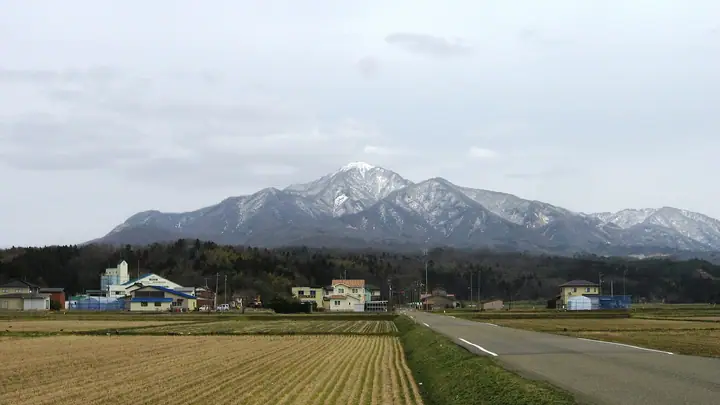
A 992 m independent peak on the boundary of Kashiwazaki City and Kakizaki Ward, Jōetsu City in Niigata Prefecture, famous for its elegant conical silhouette rising directly from the Sea of Japan coast. The summit holds Yoneyama Yakushi-dō, counted among Japan's three great Yakushi temples, and the mountain has been a center of folk worship by the Yoneyama-kō pilgrimage groups for centuries. Capped by a first-class triangulation station, it is selected for the Japan 300 Famous Mountains and is the lead peak of the Kariwa Sanzan. The official mountain-opening ceremony is held on the first Sunday in June each year.
Mount Yoneyama at a glance
- Weather: The most settled day in the next 7 days is Thu, November 5: clear, gusts up to 8 m/s. Fri, Nov 6, Sat, Nov 7: strong wind (gusts up to 24 m/s).
- Route: The shortest is Mount Yoneyama from Mizuno Forest Road: about 2 h 44 min, 3.9 km, about 480 m of climbing.
Mount Yoneyama weather (hourly, 14 days)
Sunrise today 06:12, sunset 16:48
| Tue, 11/3 | Wed, 11/4 | Thu, 11/5 | Fri, 11/6 | Sat, 11/7 | Sun, 11/8 | Mon, 11/9 | Tue, 11/10 | Wed, 11/11 | Thu, 11/12 | Fri, 11/13 | Sat, 11/14 | Sun, 11/15 | Mon, 11/16 | Tue, 11/17 | |||||||||||||||||||||||||||||||||||||||||||||||||||||||||||||||||||||
|---|---|---|---|---|---|---|---|---|---|---|---|---|---|---|---|---|---|---|---|---|---|---|---|---|---|---|---|---|---|---|---|---|---|---|---|---|---|---|---|---|---|---|---|---|---|---|---|---|---|---|---|---|---|---|---|---|---|---|---|---|---|---|---|---|---|---|---|---|---|---|---|---|---|---|---|---|---|---|---|---|---|---|---|
| Japan time | 21 | 23 | 1 | 3 | 5 | 7 | 9 | 11 | 13 | 15 | 17 | 19 | 21 | 0 | 3 | 6 | 9 | 12 | 15 | 18 | 21 | 0 | 3 | 6 | 9 | 12 | 15 | 18 | 21 | 0 | 3 | 6 | 9 | 12 | 15 | 18 | 21 | 0 | 3 | 6 | 9 | 12 | 15 | 18 | 21 | 0 | 3 | 6 | 9 | 15 | 21 | 3 | 9 | 15 | 21 | 3 | 9 | 15 | 21 | 3 | 9 | 15 | 21 | 3 | 9 | 15 | 21 | 3 | 9 | 15 | 21 | 3 | 9 | 15 | 21 | 3 | 9 | 15 | 21 | 3 | 9 | 15 | |
  | | | |  |  | | |   | | |   | | |   | |   | | | | | |   | |   | | | | | | | | | | |   | | | | |   | |   | | | | | | | | |   | | | | | | | | |   | | | | | |   | | | |  | | | | | | | | | | | | ||
| Temperature | °C | 4° | 3° | 3° | 2° | 1° | 3° | 9° | 11° | 12° | 11° | 8° | 7° | 9° | 9° | 7° | 7° | 11° | 15° | 14° | 10° | 10° | 9° | 9° | 10° | 11° | 13° | 12° | 8° | 6° | 5° | 4° | 3° | 3° | 4° | 5° | 4° | 4° | 4° | 4° | 4° | 6° | 7° | 6° | 4° | 3° | 3° | 2° | 2° | 4° | 5° | 3° | 1° | 5° | 12° | 6° | 1° | 5° | 5° | 3° | 1° | 5° | 7° | 2° | 5° | 4° | 6° | 5° | 3° | 6° | 8° | 1° | 0° | 10° | 11° | 5° | 8° | 9° | 7° | 4° | 3° | 4° | 6° |
| Precipitation | mm | 7 | 3.9 | 0.2 | 0.8 | 0.5 | 0.2 | 3.7 | 1.5 | 1.1 | 0.6 | 1.9 | 4.4 | 7 | 6 | 6 | 5 | 2.9 | 1.9 | 1.5 | 0.7 | 0.4 | 0.2 | 0.1 | 0.4 | 0.1 | 0.7 | 1.0 | 1.3 | 1.3 | 1.3 | 0.3 | 0.5 | 1.3 | 6 | 3.2 | 3.9 | 2.5 | 2.1 | 0.1 | 0.1 | 5 | 20 | 1.5 | 3.4 | 1.6 | 7 | 12 | 1.5 | ||||||||||||||||||||||||||||||||||
| New snow | cm | – | – | ||||||||||||||||||||||||||||||||||||||||||||||||||||||||||||||||||||||||||||||||
| Snow depth | cm | 0 | 0 | 0 | 0 | 0 | 0 | 0 | 0 | 0 | 0 | 0 | 0 | 0 | 0 | 0 | 0 | 0 | 0 | 0 | 0 | 0 | 0 | 0 | 0 | 0 | 0 | 0 | 0 | 0 | 0 | 0 | 0 | 0 | 0 | 0 | 0 | 0 | 0 | 0 | 0 | 0 | 0 | 0 | 0 | 0 | 0 | 0 | 0 | 0 | 0 | 0 | 0 | 0 | 0 | 0 | 0 | 0 | 0 | 0 | 0 | 0 | 0 | 0 | 0 | 0 | 0 | 0 | 0 | 0 | 0 | 0 | 0 | 0 | 0 | 0 | 0 | 0 | 0 | 0 | 0 | 0 | 0 |
| Wind | m/s | 1 | 1 | 1 | 1 | 2 | 2 | 2 | 3 | 4 | 4 | 3 | 3 | 3 | 3 | 3 | 4 | 3 | 1 | 1 | 1 | 1 | 1 | 2 | 5 | 8 | 8 | 9 | 8 | 5 | 6 | 7 | 6 | 8 | 9 | 9 | 7 | 7 | 6 | 5 | 3 | 3 | 4 | 3 | 1 | 2 | 2 | 2 | 3 | 3 | 4 | 3 | 3 | 3 | 1 | 6 | 8 | 9 | 6 | 1 | 2 | 3 | 3 | 3 | 3 | 3 | 5 | 2 | 2 | 3 | 2 | 2 | 1 | 1 | 1 | 4 | 3 | 3 | 9 | 5 | 1 | 2 | 3 |
| Wind gusts | m/s | 2 | 3 | 3 | 3 | 3 | 4 | 6 | 8 | 10 | 10 | 10 | 7 | 7 | 8 | 8 | 8 | 8 | 6 | 3 | 3 | 4 | 3 | 4 | 10 | 17 | 19 | 24 | 20 | 16 | 13 | 16 | 16 | 16 | 20 | 21 | 19 | 15 | 14 | 14 | 12 | 7 | 10 | 10 | 7 | 5 | 4 | 4 | 6 | 7 | 9 | 10 | 7 | 8 | 9 | 17 | 22 | 24 | 20 | 13 | 6 | 7 | 9 | 8 | 12 | 9 | 11 | 11 | 6 | 7 | 7 | 6 | 4 | 4 | 6 | 8 | 9 | 9 | 19 | 20 | 11 | 7 | 7 |
| Wind dir. | ↓ | ↓ | ↓ | ↓ | ↓ | ↓ | ↓ | ↓ | ↓ | ↓ | ↓ | ↓ | ↓ | ↓ | ↓ | ↓ | ↓ | ↓ | ↓ | ↓ | ↓ | ↓ | ↓ | ↓ | ↓ | ↓ | ↓ | ↓ | ↓ | ↓ | ↓ | ↓ | ↓ | ↓ | ↓ | ↓ | ↓ | ↓ | ↓ | ↓ | ↓ | ↓ | ↓ | ↓ | ↓ | ↓ | ↓ | ↓ | ↓ | ↓ | ↓ | ↓ | ↓ | ↓ | ↓ | ↓ | ↓ | ↓ | ↓ | ↓ | ↓ | ↓ | ↓ | ↓ | ↓ | ↓ | ↓ | ↓ | ↓ | ↓ | ↓ | ↓ | ↓ | ↓ | ↓ | ↓ | ↓ | ↓ | ↓ | ↓ | ↓ | ↓ | |
Mount Yoneyama hiking routes
- Mount Yoneyama from Mizuno Forest Road 3.9 km · Ascent 480 m 水野林道登山口 (parking)
- Mount Yoneyama Odaira Course Out-and-Back 5.9 km · Ascent 858 m 米山 大平コース登山口駐車場
- Mount Yoneyama Return via the Shimomaki Route 6.3 km · Ascent 776 m 下牧登山口 (parking)
Hiking times are estimates calculated from the terrain.
Huts, campsites and lodging near Mount Yoneyama
Mountain huts
Lists that include Mount Yoneyama
Japan's 300 Famous Mountains · 100 Low Mountains of Japan · Illustrated Collection of Japan's Famous Mountains · Koshinetsu 100 Famous Mountains · Niigata 100 Famous Mountains · Elevations of 1003 Mountains of Japan · 1000 Mountains of Japan
Mount Yoneyama facts
- Elevation
- 992 m
- Location
- Jōetsu-shi, Niigata
37.289585, 138.484007 - Website
- www.city.kashiwazaki.lg.jp
- Trail Map
- www.city.kashiwazaki.lg.jp (PDF)
- Access Information
- www.city.kashiwazaki.lg.jp
- Wikipedia
- ja.wikipedia.org