
Mount Yokotsu
横津岳
Nanae, Hokkaido · Elevation 1,167 m
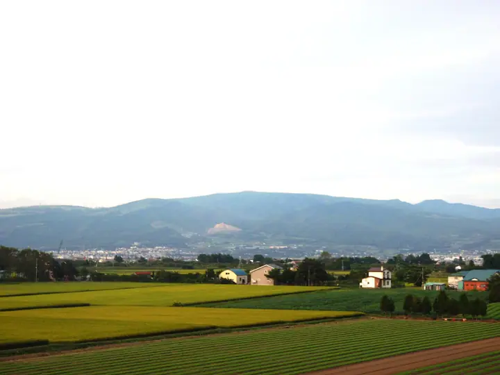
Mount Yokotsu is a 1,167 m peak in Nanae Town of Hokkaido — the highest summit of the Kameda Peninsula and the watershed divide between Uchiura Bay and the Tsugaru Strait. Its name derives from the Ainu 'yuoktu' meaning 'a place of many deer'. The summit area lies in the Esan Prefectural Natural Park designated in 1961, where gentle grasslands and alpine plant communities spread across the slopes. A paved road climbs to within 2 km of the summit, and on clear days the top commands views of Mount Komagatake, Lake Ōnuma, Mount Hakodate, and the Tsugaru Strait. The peak is occupied by an Aeronautical Surveillance Radar and the Hakodate Local Meteorological Observatory's Doppler radar.
Mount Yokotsu at a glance
- Weather: The most settled day in the next 7 days is Thu, November 5: clear, gusts up to 6 m/s. Fri, Nov 6, Sat, Nov 7, Sun, Nov 8: strong wind (gusts up to 24 m/s).
Mount Yokotsu weather (hourly, 14 days)
Sunrise today 06:11, sunset 16:30
| Tue, 11/3 | Wed, 11/4 | Thu, 11/5 | Fri, 11/6 | Sat, 11/7 | Sun, 11/8 | Mon, 11/9 | Tue, 11/10 | Wed, 11/11 | Thu, 11/12 | Fri, 11/13 | Sat, 11/14 | Sun, 11/15 | Mon, 11/16 | Tue, 11/17 | |||||||||||||||||||||||||||||||||||||||||||||||||||||||||||||||||||||||
|---|---|---|---|---|---|---|---|---|---|---|---|---|---|---|---|---|---|---|---|---|---|---|---|---|---|---|---|---|---|---|---|---|---|---|---|---|---|---|---|---|---|---|---|---|---|---|---|---|---|---|---|---|---|---|---|---|---|---|---|---|---|---|---|---|---|---|---|---|---|---|---|---|---|---|---|---|---|---|---|---|---|---|---|---|---|
| Japan time | 15 | 17 | 19 | 21 | 23 | 1 | 3 | 5 | 7 | 9 | 11 | 13 | 15 | 18 | 21 | 0 | 3 | 6 | 9 | 12 | 15 | 18 | 21 | 0 | 3 | 6 | 9 | 12 | 15 | 18 | 21 | 0 | 3 | 6 | 9 | 12 | 15 | 18 | 21 | 0 | 3 | 6 | 9 | 12 | 15 | 18 | 21 | 0 | 3 | 6 | 9 | 15 | 21 | 3 | 9 | 15 | 21 | 3 | 9 | 15 | 21 | 3 | 9 | 15 | 21 | 3 | 9 | 15 | 21 | 3 | 9 | 15 | 21 | 3 | 9 | 15 | 21 | 3 | 9 | 15 | 21 | 3 | 9 | 15 | |
 |   | | | |   |   |  | | | | | |  | | | | |   |   | |   |   | | | |   | | |   | |   | |   |   |   |   | | | | | | | | |   | | | | |   | | |   | | | | | | | | | |   | | | | | |  | | | | |   | | | | | | |  | | | ||
| Temperature | °C | 2° | -2° | -2° | -3° | -3° | -1° | 1° | -1° | -1° | 2° | 4° | 5° | 4° | -2° | -3° | -3° | -3° | -1° | 5° | 9° | 9° | 4° | 4° | 5° | 5° | 5° | 8° | 10° | 6° | 1° | -1° | -4° | -5° | -5° | -4° | -3° | -4° | -5° | -5° | -5° | -5° | -6° | -3° | -2° | -3° | -4° | -5° | -4° | -5° | -6° | -3° | -3° | -8° | -7° | -3° | -3° | -3° | -4° | -3° | -1° | -5° | -7° | -2° | -1° | -7° | -7° | -4° | -4° | -7° | -8° | -1° | 1° | -6° | -1° | 2° | 4° | 2° | 0° | 0° | -2° | -5° | -6° | -2° | 0° |
| Precipitation | mm | 1.7 | 0.6 | 0.9 | 3.6 | 0.3 | 2.4 | 0.2 | 0.7 | 0.1 | 0.4 | 0.3 | 0.6 | 0.7 | 0.8 | 0.6 | 0.5 | 0.4 | 0.3 | 0.2 | 0.4 | 4.7 | 1.7 | 0.1 | 0.4 | 0.9 | 0.2 | 0.1 | 0.4 | 0.6 | 1.1 | 3.9 | 1.8 | 1.4 | |||||||||||||||||||||||||||||||||||||||||||||||||||
| New snow | cm | 0.2 | <.1 | 0.4 | 0.3 | 0.6 | 0.7 | 0.8 | 0.6 | 0.5 | 0.3 | 0.3 | 0.2 | <.1 | <.1 | <.1 | <.1 | <.1 | 0.4 | 4.6 | 1.7 | <.1 | 0.4 | 0.4 | <.1 | 0.1 | <.1 | ||||||||||||||||||||||||||||||||||||||||||||||||||||||||||
| Snow depth | cm | 0 | 0 | 0 | 0 | 0 | 0 | 0 | 0 | 0 | 0 | 0 | 0 | 0 | 0 | 0 | 0 | 0 | 0 | 0 | 0 | 0 | 0 | 0 | 0 | 0 | 0 | 0 | 0 | 0 | 0 | 0 | 0 | 0 | <1 | <1 | 1 | 2 | 2 | 2 | 2 | 2 | 2 | 2 | 2 | 2 | 2 | 2 | 2 | 2 | 2 | 2 | 2 | 2 | 2 | 2 | 2 | 2 | 5 | 6 | 4 | 4 | 4 | 4 | 3 | 3 | 3 | 3 | 3 | 3 | 3 | 3 | 3 | 3 | 3 | 2 | 2 | <1 | <1 | <1 | 0 | 0 | 0 | 0 | 0 |
| Wind | m/s | 4 | 2 | 1 | 1 | 2 | 4 | 4 | 3 | 2 | 3 | 2 | 2 | 2 | 1 | 1 | 1 | 1 | 0 | 0 | 1 | 1 | 0 | 0 | 1 | 1 | 2 | 3 | 5 | 5 | 5 | 6 | 5 | 5 | 5 | 6 | 7 | 6 | 5 | 5 | 5 | 5 | 4 | 6 | 7 | 6 | 3 | 2 | 2 | 1 | 1 | 4 | 3 | 1 | 0 | 0 | 2 | 3 | 5 | 3 | 2 | 1 | 0 | 1 | 2 | 1 | 1 | 4 | 3 | 2 | 0 | 0 | 2 | 0 | 2 | 3 | 2 | 2 | 1 | 4 | 5 | 3 | 2 | 2 | 3 |
| Wind gusts | m/s | 14 | 12 | 9 | 9 | 11 | 18 | 17 | 16 | 13 | 12 | 11 | 7 | 8 | 7 | 7 | 6 | 6 | 5 | 4 | 5 | 6 | 4 | 5 | 8 | 7 | 7 | 11 | 14 | 19 | 20 | 21 | 21 | 20 | 20 | 21 | 24 | 24 | 21 | 19 | 19 | 20 | 20 | 21 | 22 | 23 | 20 | 13 | 10 | 9 | 9 | 12 | 13 | 12 | 7 | 5 | 8 | 13 | 16 | 16 | 10 | 7 | 5 | 7 | 13 | 10 | 8 | 12 | 14 | 12 | 9 | 5 | 9 | 8 | 8 | 10 | 10 | 9 | 8 | 13 | 17 | 16 | 13 | 10 | 11 |
| Wind dir. | ↓ | ↓ | ↓ | ↓ | ↓ | ↓ | ↓ | ↓ | ↓ | ↓ | ↓ | ↓ | ↓ | ↓ | ↓ | ↓ | ↓ | ↓ | ↓ | ↓ | ↓ | ↓ | ↓ | ↓ | ↓ | ↓ | ↓ | ↓ | ↓ | ↓ | ↓ | ↓ | ↓ | ↓ | ↓ | ↓ | ↓ | ↓ | ↓ | ↓ | ↓ | ↓ | ↓ | ↓ | ↓ | ↓ | ↓ | ↓ | ↓ | ↓ | ↓ | ↓ | ↓ | ↓ | ↓ | ↓ | ↓ | ↓ | ↓ | ↓ | ↓ | ↓ | ↓ | ↓ | ↓ | ↓ | ↓ | ↓ | ↓ | ↓ | ↓ | ↓ | ↓ | ↓ | ↓ | ↓ | ↓ | ↓ | ↓ | ↓ | ↓ | ↓ | ↓ | ||
Lists that include Mount Yokotsu
Elevations of 1003 Mountains of Japan · 1000 Mountains of Japan
Mount Yokotsu facts
- Elevation
- 1,167 m
- Location
- Nanae, Hokkaido
41.937806, 140.771196 - Website
- www.oshima.pref.hokkaido.lg.jp
- Trail Map
- www.oshima.pref.hokkaido.lg.jp (PDF)
- Wikipedia
- ja.wikipedia.org