
Mount Tashiro
田代岳
Ōdate, Akita · Elevation 1,178 m
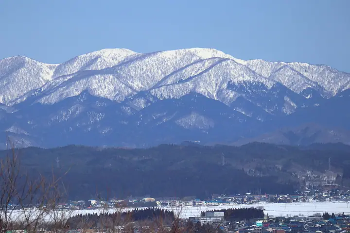
Mount Tashiro (1,178 m) stands at the northwestern end of Ōdate City, Akita Prefecture, near the Aomori border, forming the eastern flank of the Shirakami range and the centerpiece of Tashirodake Prefectural Natural Park. Around the ninth station spreads an alpine wetland known as the "Alaska Garden in the clouds," dotted with more than 120 small pools. Five official routes (Daihirote, Arasawa, Usushi, Kami-Arasawa and a ridge traverse) climb from the Iwase-zawa and Hayaguchi-zawa drainages. The peak is included in the One Hundred Mountains of Tohoku.
Mount Tashiro at a glance
- Weather: The most settled day in the next 7 days is Thu, November 5: cloudy, gusts up to 7 m/s. Fri, Nov 6, Sat, Nov 7, Sun, Nov 8: strong wind (gusts up to 21 m/s).
Mount Tashiro weather (hourly, 14 days)
Sunrise today 06:10, sunset 16:34
| Tue, 11/3 | Wed, 11/4 | Thu, 11/5 | Fri, 11/6 | Sat, 11/7 | Sun, 11/8 | Mon, 11/9 | Tue, 11/10 | Wed, 11/11 | Thu, 11/12 | Fri, 11/13 | Sat, 11/14 | Sun, 11/15 | Mon, 11/16 | Tue, 11/17 | |||||||||||||||||||||||||||||||||||||||||||||||||||||||||||||||||||||||
|---|---|---|---|---|---|---|---|---|---|---|---|---|---|---|---|---|---|---|---|---|---|---|---|---|---|---|---|---|---|---|---|---|---|---|---|---|---|---|---|---|---|---|---|---|---|---|---|---|---|---|---|---|---|---|---|---|---|---|---|---|---|---|---|---|---|---|---|---|---|---|---|---|---|---|---|---|---|---|---|---|---|---|---|---|---|
| Japan time | 15 | 17 | 19 | 21 | 23 | 1 | 3 | 5 | 7 | 9 | 11 | 13 | 15 | 18 | 21 | 0 | 3 | 6 | 9 | 12 | 15 | 18 | 21 | 0 | 3 | 6 | 9 | 12 | 15 | 18 | 21 | 0 | 3 | 6 | 9 | 12 | 15 | 18 | 21 | 0 | 3 | 6 | 9 | 12 | 15 | 18 | 21 | 0 | 3 | 6 | 9 | 15 | 21 | 3 | 9 | 15 | 21 | 3 | 9 | 15 | 21 | 3 | 9 | 15 | 21 | 3 | 9 | 15 | 21 | 3 | 9 | 15 | 21 | 3 | 9 | 15 | 21 | 3 | 9 | 15 | 21 | 3 | 9 | 15 | |
  |  | | | |   |   |   |  | | | | | | |  | |   |   |   | |   | | | | | |   | | | |   |   |   |   |   | | | | | | | | | | | | | | | | | | |   |   |   | |   | | | | |   | | | | | | | | |  | | | | |   | | |   | | | | ||
| Temperature | °C | 4° | 0° | -1° | -1° | -1° | 0° | 2° | 2° | 2° | 6° | 8° | 8° | 7° | 1° | 1° | 1° | 3° | 4° | 7° | 9° | 8° | 7° | 7° | 6° | 5° | 5° | 8° | 9° | 7° | 3° | 0° | -2° | -2° | -3° | -1° | -1° | -1° | -2° | -3° | -3° | -3° | -3° | -1° | 0° | -1° | -3° | -3° | -4° | -3° | -4° | -2° | -1° | -4° | -4° | -1° | 1° | -2° | -1° | -2° | -1° | -2° | -3° | 2° | 1° | -1° | -3° | -2° | -1° | -4° | -4° | 1° | 3° | -3° | -3° | 4° | 6° | 2° | 3° | 4° | 0° | -4° | -3° | 0° | 1° |
| Precipitation | mm | 0.6 | 0.2 | 0.2 | 1.0 | 2.4 | 1.8 | 0.2 | 0.2 | 1.9 | 1.0 | 0.2 | 0.3 | 0.2 | 0.5 | 0.6 | 1.0 | 1.2 | 1.1 | 0.8 | 0.7 | 0.6 | 0.7 | 0.5 | 0.2 | 0.1 | 0.2 | 0.4 | 2.2 | 4.3 | 11 | 1.0 | 0.2 | 3.1 | 1.6 | 0.2 | 0.2 | 2.5 | 4.1 | 1.4 | 3.8 | 2.5 | |||||||||||||||||||||||||||||||||||||||||||
| New snow | cm | <.1 | 0.4 | 0.5 | 1.0 | 1.2 | 1.0 | 0.8 | 0.7 | 0.6 | 0.7 | 0.5 | 0.2 | <.1 | <.1 | <.1 | 0.2 | 0.3 | <.1 | <.1 | 1.7 | 1.6 | 8.0 | 0.1 | 0.3 | <.1 | <.1 | 0.3 | <.1 | 0.5 | |||||||||||||||||||||||||||||||||||||||||||||||||||||||
| Snow depth | cm | 0 | 0 | 0 | 0 | 0 | 0 | 0 | 0 | 0 | 0 | 0 | 0 | 0 | 0 | 0 | 0 | 0 | 0 | 0 | 0 | 0 | 0 | 0 | 0 | 0 | 0 | 0 | 0 | 0 | 0 | 0 | 0 | 0 | <1 | <1 | 2 | 2 | 2 | 2 | 2 | 2 | 3 | 3 | 3 | 2 | 2 | 2 | 2 | 2 | 2 | 2 | 2 | 1 | 1 | 1 | 1 | 2 | 2 | 6 | 4 | 4 | 4 | 3 | 2 | 1 | 1 | 1 | <1 | <1 | <1 | <1 | <1 | <1 | <1 | 0 | 0 | 0 | 0 | 0 | 0 | 0 | 0 | 0 | 0 |
| Wind | m/s | 5 | 2 | 2 | 2 | 2 | 3 | 5 | 4 | 2 | 2 | 2 | 1 | 1 | 2 | 1 | 1 | 1 | 1 | 2 | 2 | 1 | 0 | 0 | 1 | 2 | 2 | 3 | 5 | 6 | 5 | 6 | 5 | 5 | 6 | 7 | 7 | 7 | 6 | 5 | 5 | 5 | 5 | 6 | 7 | 6 | 3 | 2 | 2 | 2 | 2 | 2 | 3 | 2 | 1 | 1 | 4 | 3 | 1 | 5 | 3 | 1 | 1 | 3 | 3 | 1 | 2 | 4 | 4 | 1 | 0 | 1 | 2 | 2 | 2 | 2 | 2 | 2 | 2 | 2 | 4 | 3 | 2 | 2 | 2 |
| Wind gusts | m/s | 13 | 12 | 7 | 7 | 8 | 10 | 13 | 14 | 12 | 8 | 7 | 6 | 6 | 4 | 5 | 4 | 3 | 5 | 6 | 7 | 6 | 3 | 2 | 4 | 6 | 6 | 8 | 14 | 16 | 15 | 18 | 17 | 15 | 16 | 18 | 21 | 21 | 18 | 16 | 15 | 15 | 15 | 16 | 18 | 18 | 15 | 9 | 7 | 7 | 6 | 7 | 8 | 7 | 5 | 4 | 10 | 12 | 12 | 13 | 14 | 8 | 5 | 9 | 11 | 9 | 7 | 10 | 13 | 10 | 4 | 4 | 6 | 6 | 5 | 7 | 8 | 8 | 7 | 5 | 12 | 12 | 9 | 7 | 8 |
| Wind dir. | ↓ | ↓ | ↓ | ↓ | ↓ | ↓ | ↓ | ↓ | ↓ | ↓ | ↓ | ↓ | ↓ | ↓ | ↓ | ↓ | ↓ | ↓ | ↓ | ↓ | ↓ | ↓ | ↓ | ↓ | ↓ | ↓ | ↓ | ↓ | ↓ | ↓ | ↓ | ↓ | ↓ | ↓ | ↓ | ↓ | ↓ | ↓ | ↓ | ↓ | ↓ | ↓ | ↓ | ↓ | ↓ | ↓ | ↓ | ↓ | ↓ | ↓ | ↓ | ↓ | ↓ | ↓ | ↓ | ↓ | ↓ | ↓ | ↓ | ↓ | ↓ | ↓ | ↓ | ↓ | ↓ | ↓ | ↓ | ↓ | ↓ | ↓ | ↓ | ↓ | ↓ | ↓ | ↓ | ↓ | ↓ | ↓ | ↓ | ↓ | ↓ | ↓ | ↓ | ↓ | |
Huts, campsites and lodging near Mount Tashiro
Mountain huts
- 田代岳山頂避難小屋
- 薄市山の家
Lists that include Mount Tashiro
Tohoku 100 Famous Mountains · Elevations of 1003 Mountains of Japan · 1000 Mountains of Japan
Mount Tashiro facts
- Elevation
- 1,178 m
- Location
- Ōdate, Akita
40.428492, 140.408835 - Website
- www.city.odate.lg.jp
- Trail Map
- www.city.odate.lg.jp (PDF)
- Access Information
- www.city.odate.lg.jp
- Wikipedia
- ja.wikipedia.org