
Mount Takeda
武田山
Hiroshima, Hiroshima · Elevation 411 m
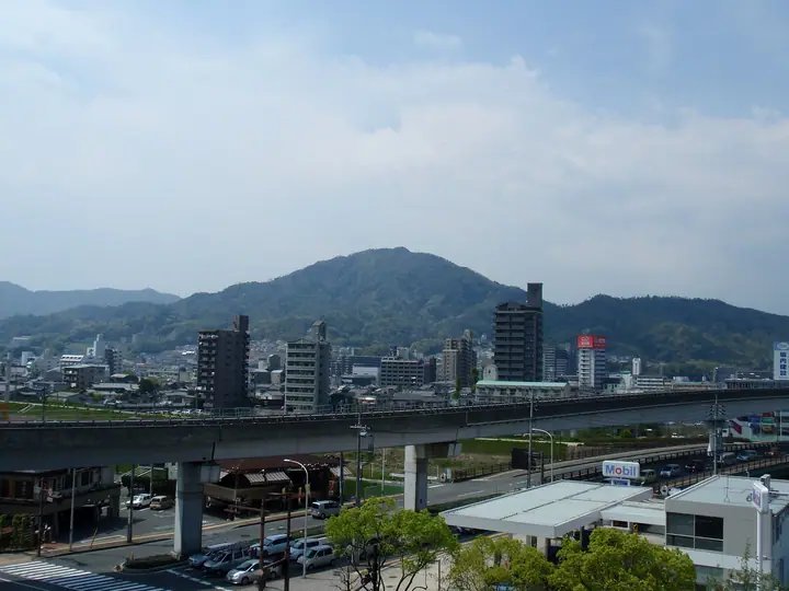
Mount Takeda (410.5 m) rises above the Gion district of Asaminami Ward in Hiroshima City. Its summit and slopes preserve the ruins of Satō-Kanayama Castle, the medieval stronghold of the Aki Takeda clan who governed the province before the Mōri shifted their base to Hiroshima. Some fifty bailies, horse-turns, lookouts, and the rocky 'Omori Iwadai' summit citadel are scattered between the foothills and peak, and the slopes lie along the Chūgoku Nature Trail. Panoramic views from the southern crest take in Hiroshima city, the Ōta River, and the Seto Inland Sea, and the mountain is counted in the Hiroshima Hyakuzan and Hiroshima Prefecture 100 lists.
Mount Takeda at a glance
- Weather: The most settled day in the next 7 days is Thu, November 5: cloudy, gusts up to 4 m/s.
- Route: The shortest is Mount Takeda and Kanayama Castle Ruins Loop from Ikoi no Mori: about 2 h 11 min, 4.1 km, about 400 m of climbing.
Mount Takeda weather (hourly, 14 days)
Sunrise today 06:31, sunset 17:16
| Tue, 11/3 | Wed, 11/4 | Thu, 11/5 | Fri, 11/6 | Sat, 11/7 | Sun, 11/8 | Mon, 11/9 | Tue, 11/10 | Wed, 11/11 | Thu, 11/12 | Fri, 11/13 | Sat, 11/14 | Sun, 11/15 | Mon, 11/16 | Tue, 11/17 | |||||||||||||||||||||||||||||||||||||||||||||||||||||||||||||||||||||||
|---|---|---|---|---|---|---|---|---|---|---|---|---|---|---|---|---|---|---|---|---|---|---|---|---|---|---|---|---|---|---|---|---|---|---|---|---|---|---|---|---|---|---|---|---|---|---|---|---|---|---|---|---|---|---|---|---|---|---|---|---|---|---|---|---|---|---|---|---|---|---|---|---|---|---|---|---|---|---|---|---|---|---|---|---|---|
| Japan time | 15 | 17 | 19 | 21 | 23 | 1 | 3 | 5 | 7 | 9 | 11 | 13 | 15 | 18 | 21 | 0 | 3 | 6 | 9 | 12 | 15 | 18 | 21 | 0 | 3 | 6 | 9 | 12 | 15 | 18 | 21 | 0 | 3 | 6 | 9 | 12 | 15 | 18 | 21 | 0 | 3 | 6 | 9 | 12 | 15 | 18 | 21 | 0 | 3 | 6 | 9 | 15 | 21 | 3 | 9 | 15 | 21 | 3 | 9 | 15 | 21 | 3 | 9 | 15 | 21 | 3 | 9 | 15 | 21 | 3 | 9 | 15 | 21 | 3 | 9 | 15 | 21 | 3 | 9 | 15 | 21 | 3 | 9 | 15 | |
  |   |   | | | | |   | | | | | | |   | | | | |   |   |   | |   | | | |  | |  | | | | | | | | | | | | | | | | | | | | | |   |   | | | | | | | | |  | | | | | | | | | | | | | | | |   | | | |  | | | ||
| Temperature | °C | 16° | 14° | 12° | 11° | 10° | 9° | 8° | 8° | 8° | 12° | 15° | 17° | 16° | 14° | 12° | 11° | 10° | 11° | 13° | 17° | 17° | 15° | 15° | 14° | 14° | 12° | 15° | 17° | 15° | 11° | 9° | 9° | 8° | 7° | 10° | 12° | 12° | 8° | 5° | 3° | 3° | 2° | 9° | 12° | 14° | 11° | 10° | 9° | 9° | 8° | 12° | 15° | 8° | 6° | 11° | 13° | 8° | 7° | 9° | 12° | 5° | 2° | 8° | 12° | 6° | 5° | 11° | 13° | 6° | 3° | 9° | 15° | 9° | 8° | 10° | 12° | 12° | 11° | 14° | 16° | 9° | 5° | 8° | 13° |
| Precipitation | mm | 0.2 | 0.7 | 0.3 | 0.7 | 1.9 | 0.6 | 0.9 | 0.2 | 0.2 | 8 | 18 | |||||||||||||||||||||||||||||||||||||||||||||||||||||||||||||||||||||||||
| New snow | cm | ||||||||||||||||||||||||||||||||||||||||||||||||||||||||||||||||||||||||||||||||||||
| Snow depth | cm | 0 | 0 | 0 | 0 | 0 | 0 | 0 | 0 | 0 | 0 | 0 | 0 | 0 | 0 | 0 | 0 | 0 | 0 | 0 | 0 | 0 | 0 | 0 | 0 | 0 | 0 | 0 | 0 | 0 | 0 | 0 | 0 | 0 | 0 | 0 | 0 | 0 | 0 | 0 | 0 | 0 | 0 | 0 | 0 | 0 | 0 | 0 | 0 | 0 | 0 | 0 | 0 | 0 | 0 | 0 | 0 | 0 | 0 | 0 | 0 | 0 | 0 | 0 | 0 | 0 | 0 | 0 | 0 | 0 | 0 | 0 | 0 | 0 | 0 | 0 | 0 | 0 | 0 | 0 | 0 | 0 | 0 | 0 | 0 |
| Wind | m/s | 4 | 4 | 4 | 3 | 2 | 2 | 2 | 2 | 2 | 2 | 2 | 2 | 2 | 1 | 1 | 2 | 2 | 1 | 1 | 0 | 1 | 1 | 1 | 3 | 2 | 2 | 1 | 4 | 4 | 3 | 2 | 3 | 3 | 2 | 4 | 3 | 3 | 2 | 1 | 1 | 2 | 2 | 2 | 2 | 2 | 1 | 2 | 2 | 2 | 2 | 1 | 3 | 2 | 0 | 1 | 4 | 3 | 4 | 2 | 4 | 1 | 1 | 1 | 3 | 1 | 0 | 2 | 4 | 2 | 2 | 2 | 3 | 1 | 2 | 1 | 0 | 1 | 1 | 3 | 4 | 4 | 2 | 2 | 2 |
| Wind gusts | m/s | 10 | 10 | 9 | 8 | 7 | 5 | 5 | 5 | 5 | 5 | 7 | 6 | 6 | 4 | 3 | 4 | 5 | 4 | 4 | 4 | 3 | 4 | 4 | 7 | 8 | 6 | 4 | 10 | 11 | 10 | 6 | 7 | 8 | 7 | 9 | 9 | 9 | 8 | 5 | 4 | 4 | 5 | 5 | 6 | 6 | 5 | 4 | 4 | 4 | 4 | 4 | 9 | 8 | 4 | 3 | 12 | 10 | 10 | 9 | 9 | 9 | 4 | 4 | 7 | 7 | 3 | 6 | 10 | 8 | 5 | 5 | 7 | 7 | 4 | 4 | 5 | 7 | 4 | 6 | 11 | 12 | 10 | 6 | 7 |
| Wind dir. | ↓ | ↓ | ↓ | ↓ | ↓ | ↓ | ↓ | ↓ | ↓ | ↓ | ↓ | ↓ | ↓ | ↓ | ↓ | ↓ | ↓ | ↓ | ↓ | ↓ | ↓ | ↓ | ↓ | ↓ | ↓ | ↓ | ↓ | ↓ | ↓ | ↓ | ↓ | ↓ | ↓ | ↓ | ↓ | ↓ | ↓ | ↓ | ↓ | ↓ | ↓ | ↓ | ↓ | ↓ | ↓ | ↓ | ↓ | ↓ | ↓ | ↓ | ↓ | ↓ | ↓ | ↓ | ↓ | ↓ | ↓ | ↓ | ↓ | ↓ | ↓ | ↓ | ↓ | ↓ | ↓ | ↓ | ↓ | ↓ | ↓ | ↓ | ↓ | ↓ | ↓ | ↓ | ↓ | ↓ | ↓ | ↓ | ↓ | ↓ | ↓ | ↓ | ↓ | ↓ | |
Mount Takeda hiking routes
Hiking times are estimates calculated from the terrain.
Huts, campsites and lodging near Mount Takeda
Campsites
- boss spec
- Hiroshima City Mitaki Boys' Nature House
Lodging
- 三瀧茶屋&guesthouse Miktaki
Lists that include Mount Takeda
Mount Takeda facts
- Elevation
- 411 m
- Location
- Hiroshima, Hiroshima
34.456000, 132.448527 - Website
- www.city.hiroshima.lg.jp
- Trail Map
- www.city.hiroshima.lg.jp
- Access Information
- www.city.hiroshima.lg.jp
- Wikipedia
- ja.wikipedia.org