
Mount Taihei
太平山
Akita, Akita · Elevation 1,170 m
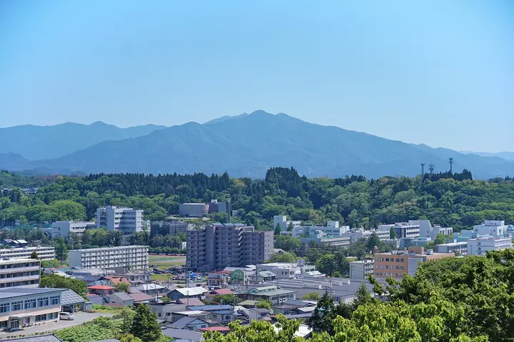
Mount Taihei is a 1,170 m peak rising in eastern Akita City, Akita Prefecture, the centre of Taiheizan Prefectural Natural Park and a long-revered local sanctuary. The summit holds the inner shrine of Taiheizan-Miyoshi-Jinja, worshipped since antiquity as a guardian of victory, success, and prosperity in business. The peak is listed in the Nihon Sanbyaku Meizan, the Shin Nihon Hyakumeizan, the Tōhoku 100 Meizan, the Nihon Hyakuteizan, and the Nihon Hyaku Reizan. The main approach is the Asahimata Course from the Asahimata Campground above the Nibetsu People's Forest — about a 3 hour 20 minute climb — with secondary trails from Noda, the Marumai forest road, and Kisoishi-guchi. The Sanrōjo lodging hut beside the inner shrine is staffed by shrine personnel in summer, providing free rest and reservation-based meals and accommodation. The summit gives sweeping views over the Akita Plain, the Oga Peninsula, and Mount Chōkai.
Mount Taihei at a glance
- Weather: The most settled day in the next 7 days is Wed, November 4: clear, gusts up to 9 m/s. Fri, Nov 6, Sat, Nov 7, Sun, Nov 8: strong wind (gusts up to 23 m/s).
Mount Taihei weather (hourly, 14 days)
Sunrise today 06:09, sunset 16:36
| Tue, 11/3 | Wed, 11/4 | Thu, 11/5 | Fri, 11/6 | Sat, 11/7 | Sun, 11/8 | Mon, 11/9 | Tue, 11/10 | Wed, 11/11 | Thu, 11/12 | Fri, 11/13 | Sat, 11/14 | Sun, 11/15 | Mon, 11/16 | Tue, 11/17 | |||||||||||||||||||||||||||||||||||||||||||||||||||||||||||||||||||||||
|---|---|---|---|---|---|---|---|---|---|---|---|---|---|---|---|---|---|---|---|---|---|---|---|---|---|---|---|---|---|---|---|---|---|---|---|---|---|---|---|---|---|---|---|---|---|---|---|---|---|---|---|---|---|---|---|---|---|---|---|---|---|---|---|---|---|---|---|---|---|---|---|---|---|---|---|---|---|---|---|---|---|---|---|---|---|
| Japan time | 15 | 17 | 19 | 21 | 23 | 1 | 3 | 5 | 7 | 9 | 11 | 13 | 15 | 18 | 21 | 0 | 3 | 6 | 9 | 12 | 15 | 18 | 21 | 0 | 3 | 6 | 9 | 12 | 15 | 18 | 21 | 0 | 3 | 6 | 9 | 12 | 15 | 18 | 21 | 0 | 3 | 6 | 9 | 12 | 15 | 18 | 21 | 0 | 3 | 6 | 9 | 15 | 21 | 3 | 9 | 15 | 21 | 3 | 9 | 15 | 21 | 3 | 9 | 15 | 21 | 3 | 9 | 15 | 21 | 3 | 9 | 15 | 21 | 3 | 9 | 15 | 21 | 3 | 9 | 15 | 21 | 3 | 9 | 15 | |
 |  |   | | |   |   |   |   | | | | | | | |   | |   | |   | | | | | | | | | | | |   |   |   |   | |   | |   |   | |   |   | | | |   | | | | | | | | | | |   | | | | | | | | | | | | | |  | | | | | | | | | | | | ||
| Temperature | °C | 3° | 0° | -1° | -2° | -2° | -2° | -1° | -1° | 0° | 4° | 6° | 7° | 6° | 0° | 0° | 3° | 3° | 4° | 5° | 6° | 7° | 5° | 5° | 5° | 5° | 5° | 6° | 8° | 5° | 1° | -1° | -3° | -3° | -4° | -3° | -2° | -3° | -4° | -3° | -3° | -4° | -4° | -2° | -1° | -1° | -2° | -3° | -4° | -3° | -5° | -2° | -1° | -5° | -7° | -2° | 2° | -3° | -2° | -1° | 0° | -6° | -4° | -1° | 0° | -2° | -2° | -2° | -2° | -4° | -6° | 0° | 1° | -4° | -5° | 3° | 4° | 2° | 2° | 3° | -1° | -5° | -5° | -2° | 0° |
| Precipitation | mm | 0.1 | 0.7 | 0.3 | 0.2 | 3.1 | 2.8 | 0.5 | 0.8 | 1.0 | 2.0 | 2.0 | 1.0 | 2.4 | 5 | 4.2 | 0.7 | 3.2 | 0.8 | 0.9 | 0.8 | 1.7 | 1.5 | 0.8 | 0.4 | 0.2 | 0.1 | 0.3 | 0.1 | 0.5 | 0.1 | 2.9 | 9 | 2.8 | 0.7 | 6 | 1.9 | 4.5 | 1.2 | 3.7 | 2.5 | ||||||||||||||||||||||||||||||||||||||||||||
| New snow | cm | <.1 | 0.3 | 1.5 | 1.2 | 0.6 | 0.3 | 0.1 | <.1 | 0.2 | <.1 | <.1 | <.1 | 0.9 | <.1 | ||||||||||||||||||||||||||||||||||||||||||||||||||||||||||||||||||||||
| Snow depth | cm | 0 | 0 | 0 | 0 | 0 | 0 | 0 | 0 | 0 | 0 | 0 | 0 | 0 | 0 | 0 | 0 | 0 | 0 | 0 | 0 | 0 | 0 | 0 | 0 | 0 | 0 | 0 | 0 | 0 | 0 | 0 | 0 | 0 | <1 | <1 | <1 | <1 | <1 | <1 | <1 | <1 | <1 | <1 | <1 | 0 | 0 | 0 | 0 | 0 | 0 | 0 | 0 | 0 | 0 | 0 | 0 | <1 | 0 | 0 | 0 | 0 | 0 | 0 | 0 | 0 | 0 | 0 | 0 | 0 | 0 | 0 | 0 | 0 | 0 | 0 | 0 | 0 | 0 | 0 | 0 | 0 | 0 | 0 | 0 |
| Wind | m/s | 5 | 3 | 3 | 1 | 1 | 1 | 3 | 0 | 3 | 3 | 3 | 3 | 2 | 1 | 2 | 3 | 3 | 3 | 3 | 2 | 2 | 2 | 0 | 1 | 1 | 0 | 2 | 6 | 5 | 5 | 6 | 4 | 5 | 6 | 6 | 8 | 7 | 6 | 6 | 5 | 6 | 6 | 7 | 8 | 7 | 4 | 3 | 2 | 3 | 1 | 4 | 3 | 2 | 2 | 2 | 4 | 5 | 1 | 2 | 4 | 2 | 0 | 0 | 3 | 0 | 2 | 4 | 5 | 2 | 2 | 1 | 2 | 0 | 1 | 1 | 1 | 2 | 1 | 1 | 6 | 4 | 2 | 1 | 2 |
| Wind gusts | m/s | 13 | 13 | 8 | 8 | 5 | 5 | 7 | 8 | 8 | 9 | 9 | 9 | 8 | 4 | 5 | 8 | 9 | 9 | 9 | 9 | 5 | 5 | 3 | 4 | 4 | 4 | 6 | 17 | 17 | 14 | 15 | 15 | 13 | 15 | 17 | 23 | 22 | 20 | 18 | 17 | 16 | 16 | 17 | 19 | 20 | 17 | 11 | 8 | 7 | 7 | 9 | 9 | 8 | 6 | 6 | 9 | 16 | 13 | 7 | 15 | 10 | 5 | 4 | 11 | 8 | 5 | 11 | 14 | 13 | 6 | 5 | 9 | 6 | 3 | 4 | 7 | 5 | 5 | 5 | 15 | 16 | 11 | 6 | 8 |
| Wind dir. | ↓ | ↓ | ↓ | ↓ | ↓ | ↓ | ↓ | ↓ | ↓ | ↓ | ↓ | ↓ | ↓ | ↓ | ↓ | ↓ | ↓ | ↓ | ↓ | ↓ | ↓ | ↓ | ↓ | ↓ | ↓ | ↓ | ↓ | ↓ | ↓ | ↓ | ↓ | ↓ | ↓ | ↓ | ↓ | ↓ | ↓ | ↓ | ↓ | ↓ | ↓ | ↓ | ↓ | ↓ | ↓ | ↓ | ↓ | ↓ | ↓ | ↓ | ↓ | ↓ | ↓ | ↓ | ↓ | ↓ | ↓ | ↓ | ↓ | ↓ | ↓ | ↓ | ↓ | ↓ | ↓ | ↓ | ↓ | ↓ | ↓ | ↓ | ↓ | ↓ | ↓ | ↓ | ↓ | ↓ | ↓ | ↓ | ↓ | ↓ | ↓ | ↓ | ↓ | ↓ | |
Lists that include Mount Taihei
Japan's 300 Famous Mountains · New Japan 100 Famous Mountains · 100 Low Mountains of Japan · Tohoku 100 Famous Mountains · Elevations of 1003 Mountains of Japan · 1000 Mountains of Japan
Mount Taihei facts
- Elevation
- 1,170 m
- Location
- Akita, Akita
39.797034, 140.310645 - Website
- www.city.akita.lg.jp
- Trail Map
- www.city.akita.lg.jp (PDF)
- Access Information
- www.city.akita.lg.jp
- Wikipedia
- ja.wikipedia.org