
Mount Sazaegatake
蠑螺が岳
Tsuruga, Fukui · Elevation 686 m
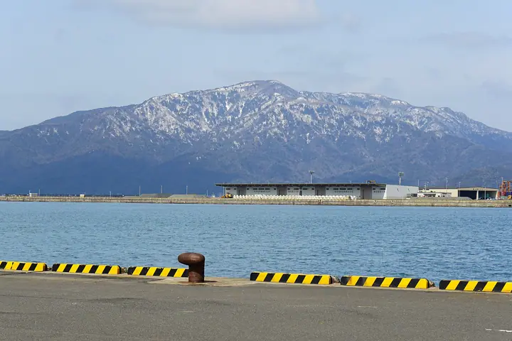
A 686 m peak on the main spine of the Tsuruga Peninsula in Tsuruga City, Fukui. Together with neighbouring Mount Saihō (764 m) to the south, it forms the peninsula's signature ridge. The whole massif is granite, and weathering has bared white slabs that give the slopes an alpine look. Summit views reach across Tsuruga and Wakasa Bays to the Hakusan range and Lake Biwa. The classic traverse climbs from the Jōgū-jinja trailhead over Saihōgatake to Sazaegatake and descends to Urasoko.
Mount Sazaegatake at a glance
- Weather: The most settled day in the next 7 days is Wed, November 4: clear, gusts up to 5 m/s.
- Route: The shortest is Tsuruga Peninsula Traverse from Jogu Shrine over Saihogadake and Kamoshikadai to Sazaegadake: about 5 h 25 min, 8.3 km, about 890 m of climbing.
Mount Sazaegatake weather (hourly, 14 days)
Sunrise today 06:19, sunset 17:00
| Tue, 11/3 | Wed, 11/4 | Thu, 11/5 | Fri, 11/6 | Sat, 11/7 | Sun, 11/8 | Mon, 11/9 | Tue, 11/10 | Wed, 11/11 | Thu, 11/12 | Fri, 11/13 | Sat, 11/14 | Sun, 11/15 | Mon, 11/16 | Tue, 11/17 | |||||||||||||||||||||||||||||||||||||||||||||||||||||||||||||||||||||||
|---|---|---|---|---|---|---|---|---|---|---|---|---|---|---|---|---|---|---|---|---|---|---|---|---|---|---|---|---|---|---|---|---|---|---|---|---|---|---|---|---|---|---|---|---|---|---|---|---|---|---|---|---|---|---|---|---|---|---|---|---|---|---|---|---|---|---|---|---|---|---|---|---|---|---|---|---|---|---|---|---|---|---|---|---|---|
| Japan time | 15 | 17 | 19 | 21 | 23 | 1 | 3 | 5 | 7 | 9 | 11 | 13 | 15 | 18 | 21 | 0 | 3 | 6 | 9 | 12 | 15 | 18 | 21 | 0 | 3 | 6 | 9 | 12 | 15 | 18 | 21 | 0 | 3 | 6 | 9 | 12 | 15 | 18 | 21 | 0 | 3 | 6 | 9 | 12 | 15 | 18 | 21 | 0 | 3 | 6 | 9 | 15 | 21 | 3 | 9 | 15 | 21 | 3 | 9 | 15 | 21 | 3 | 9 | 15 | 21 | 3 | 9 | 15 | 21 | 3 | 9 | 15 | 21 | 3 | 9 | 15 | 21 | 3 | 9 | 15 | 21 | 3 | 9 | 15 | |
  |  |   | | | | | | |  | | | |   | |   | |   |   | |   | |   | | | |   | | | | | | | | | | | | | | | |   |   | |   | | | | | | | | | | | | | | | | | | | | | | |  | | | | | | | | | | | | | | | | ||
| Temperature | °C | 14° | 12° | 11° | 10° | 9° | 9° | 9° | 8° | 8° | 10° | 12° | 14° | 14° | 13° | 13° | 12° | 11° | 11° | 12° | 14° | 14° | 14° | 13° | 13° | 13° | 13° | 14° | 15° | 14° | 13° | 12° | 10° | 9° | 8° | 8° | 9° | 9° | 8° | 8° | 8° | 8° | 7° | 8° | 10° | 10° | 9° | 8° | 8° | 8° | 8° | 9° | 11° | 8° | 7° | 10° | 10° | 10° | 7° | 9° | 9° | 8° | 6° | 8° | 10° | 8° | 9° | 9° | 9° | 7° | 5° | 8° | 12° | 10° | 10° | 12° | 14° | 13° | 13° | 12° | 10° | 8° | 6° | 6° | 10° |
| Precipitation | mm | 0.6 | 2.5 | 1.4 | 2.5 | 0.1 | 0.3 | 0.1 | 0.3 | 6 | 0.6 | 6 | 0.2 | 1.7 | 0.5 | 0.6 | 0.3 | 0.5 | 1.3 | 1.4 | 0.8 | 0.1 | 0.5 | 0.5 | 0.9 | 0.7 | 3.2 | 11 | 8 | 0.5 | 0.2 | 4.5 | 1.2 | 0.1 | 4.9 | 6 | 2.7 | 1.5 | 0.1 | ||||||||||||||||||||||||||||||||||||||||||||||
| New snow | cm | ||||||||||||||||||||||||||||||||||||||||||||||||||||||||||||||||||||||||||||||||||||
| Snow depth | cm | 0 | 0 | 0 | 0 | 0 | 0 | 0 | 0 | 0 | 0 | 0 | 0 | 0 | 0 | 0 | 0 | 0 | 0 | 0 | 0 | 0 | 0 | 0 | 0 | 0 | 0 | 0 | 0 | 0 | 0 | 0 | 0 | 0 | 0 | 0 | 0 | 0 | 0 | 0 | 0 | 0 | 0 | 0 | 0 | 0 | 0 | 0 | 0 | 0 | 0 | 0 | 0 | 0 | 0 | 0 | 0 | 0 | 0 | 0 | 0 | 0 | 0 | 0 | 0 | 0 | 0 | 0 | 0 | 0 | 0 | 0 | 0 | 0 | 0 | 0 | 0 | 0 | 0 | 0 | 0 | 0 | 0 | 0 | 0 |
| Wind | m/s | 4 | 3 | 3 | 3 | 3 | 2 | 2 | 3 | 2 | 1 | 1 | 1 | 1 | 1 | 1 | 2 | 2 | 2 | 1 | 1 | 2 | 1 | 1 | 0 | 3 | 4 | 6 | 7 | 7 | 7 | 7 | 8 | 7 | 6 | 6 | 7 | 6 | 4 | 4 | 3 | 3 | 4 | 4 | 4 | 4 | 3 | 2 | 1 | 1 | 1 | 1 | 3 | 2 | 2 | 4 | 5 | 7 | 9 | 8 | 7 | 4 | 3 | 3 | 3 | 2 | 4 | 6 | 6 | 3 | 3 | 0 | 2 | 4 | 4 | 6 | 6 | 5 | 3 | 5 | 8 | 5 | 4 | 4 | 3 |
| Wind gusts | m/s | 7 | 6 | 5 | 5 | 5 | 5 | 5 | 5 | 5 | 4 | 4 | 3 | 3 | 3 | 3 | 3 | 5 | 4 | 5 | 3 | 4 | 3 | 3 | 3 | 6 | 8 | 9 | 10 | 11 | 12 | 10 | 11 | 12 | 11 | 10 | 11 | 10 | 10 | 8 | 7 | 6 | 6 | 7 | 7 | 7 | 7 | 6 | 5 | 3 | 3 | 3 | 7 | 6 | 5 | 7 | 9 | 11 | 15 | 14 | 12 | 11 | 7 | 6 | 5 | 5 | 7 | 9 | 10 | 10 | 6 | 5 | 5 | 6 | 8 | 9 | 10 | 10 | 9 | 8 | 13 | 13 | 8 | 7 | 6 |
| Wind dir. | ↓ | ↓ | ↓ | ↓ | ↓ | ↓ | ↓ | ↓ | ↓ | ↓ | ↓ | ↓ | ↓ | ↓ | ↓ | ↓ | ↓ | ↓ | ↓ | ↓ | ↓ | ↓ | ↓ | ↓ | ↓ | ↓ | ↓ | ↓ | ↓ | ↓ | ↓ | ↓ | ↓ | ↓ | ↓ | ↓ | ↓ | ↓ | ↓ | ↓ | ↓ | ↓ | ↓ | ↓ | ↓ | ↓ | ↓ | ↓ | ↓ | ↓ | ↓ | ↓ | ↓ | ↓ | ↓ | ↓ | ↓ | ↓ | ↓ | ↓ | ↓ | ↓ | ↓ | ↓ | ↓ | ↓ | ↓ | ↓ | ↓ | ↓ | ↓ | ↓ | ↓ | ↓ | ↓ | ↓ | ↓ | ↓ | ↓ | ↓ | ↓ | ↓ | ↓ | ↓ | |
Mount Sazaegatake hiking routes
Hiking times are estimates calculated from the terrain.
Huts, campsites and lodging near Mount Sazaegatake
Mountain huts
Campsites
- 丹生オートキャンプ場
Lodging
- Beach Comver
- 旅館中村屋
Mount Sazaegatake facts
- Elevation
- 686 m
- Location
- Tsuruga, Fukui
35.724927, 136.012759 - Website
- tsuruga-kanko.jp
- Wikipedia
- ja.wikipedia.org