
Mount Sanbe
男三瓶山
Ōda-shi, Shimane · Elevation 1,126 m
Mount Sanbe (Osanbe-san, 1,125.6 m) is a stratovolcano in Oda City, Shimane. Its six peaks—Osanbe, Mesanbe, Kosanbe, Magosanbe, Taihei and Hikage—surround the Muronouchi crater plateau. Within Daisen-Oki National Park, it has natural beech forest protected as a National Natural Monument, upland grasslands and Sanbe Onsen at its foot. Trails rise from Kita-no-hara, Nishi-no-hara and other trailheads, while the Higashi-no-hara chairlift provides access toward Taiheizan. Parts of the ridge traverse require care because of collapse and fall hazards.
Mount Sanbe at a glance
- Weather: The most settled day in the next 7 days is Wed, November 4: clear, gusts up to 8 m/s.
- Route: The shortest is Mount Osanbe Himenogaike Course Out-and-Back: about 3 h 8 min, 4.6 km, about 540 m of climbing.
Mount Sanbe weather (hourly, 14 days)
Sunrise today 06:32, sunset 17:14
| Tue, 11/3 | Wed, 11/4 | Thu, 11/5 | Fri, 11/6 | Sat, 11/7 | Sun, 11/8 | Mon, 11/9 | Tue, 11/10 | Wed, 11/11 | Thu, 11/12 | Fri, 11/13 | Sat, 11/14 | Sun, 11/15 | Mon, 11/16 | Tue, 11/17 | |||||||||||||||||||||||||||||||||||||||||||||||||||||||||||||||||||||||
|---|---|---|---|---|---|---|---|---|---|---|---|---|---|---|---|---|---|---|---|---|---|---|---|---|---|---|---|---|---|---|---|---|---|---|---|---|---|---|---|---|---|---|---|---|---|---|---|---|---|---|---|---|---|---|---|---|---|---|---|---|---|---|---|---|---|---|---|---|---|---|---|---|---|---|---|---|---|---|---|---|---|---|---|---|---|
| Japan time | 15 | 17 | 19 | 21 | 23 | 1 | 3 | 5 | 7 | 9 | 11 | 13 | 15 | 18 | 21 | 0 | 3 | 6 | 9 | 12 | 15 | 18 | 21 | 0 | 3 | 6 | 9 | 12 | 15 | 18 | 21 | 0 | 3 | 6 | 9 | 12 | 15 | 18 | 21 | 0 | 3 | 6 | 9 | 12 | 15 | 18 | 21 | 0 | 3 | 6 | 9 | 15 | 21 | 3 | 9 | 15 | 21 | 3 | 9 | 15 | 21 | 3 | 9 | 15 | 21 | 3 | 9 | 15 | 21 | 3 | 9 | 15 | 21 | 3 | 9 | 15 | 21 | 3 | 9 | 15 | 21 | 3 | 9 | 15 | |
  | |   | | | | | |  |   |   | | |   | |   | | |   | | |   | | |   | | | | | | | | | | | | | | | | | | | | | | | | | | | | | | |   | | |   | |   | | | | | | | | |  | | | | | | | | | | | | | | | ||
| Temperature | °C | 9° | 8° | 6° | 5° | 5° | 5° | 5° | 4° | 5° | 9° | 12° | 13° | 12° | 9° | 9° | 8° | 8° | 8° | 11° | 11° | 11° | 10° | 9° | 9° | 9° | 8° | 11° | 11° | 9° | 7° | 6° | 6° | 5° | 4° | 6° | 7° | 7° | 4° | 3° | 2° | 1° | 1° | 6° | 8° | 7° | 6° | 5° | 4° | 5° | 4° | 7° | 8° | 4° | 4° | 8° | 8° | 3° | 2° | 5° | 6° | 2° | 2° | 6° | 9° | 6° | 6° | 6° | 7° | 3° | 1° | 6° | 12° | 6° | 8° | 10° | 9° | 9° | 9° | 9° | 6° | 4° | 2° | 4° | 6° |
| Precipitation | mm | 1.6 | 0.5 | 0.1 | 0.5 | 2.6 | 4.9 | 4.0 | 3.6 | 3.5 | 0.5 | 0.2 | 0.3 | 2.2 | 0.2 | 0.2 | 0.9 | 0.3 | 1.2 | 0.3 | 0.2 | 0.9 | 6 | 19 | 3.2 | 5 | 3.3 | 0.9 | |||||||||||||||||||||||||||||||||||||||||||||||||||||||||
| New snow | cm | ||||||||||||||||||||||||||||||||||||||||||||||||||||||||||||||||||||||||||||||||||||
| Snow depth | cm | 0 | 0 | 0 | 0 | 0 | 0 | 0 | 0 | 0 | 0 | 0 | 0 | 0 | 0 | 0 | 0 | 0 | 0 | 0 | 0 | 0 | 0 | 0 | 0 | 0 | 0 | 0 | 0 | 0 | 0 | 0 | 0 | 0 | 0 | 0 | 0 | 0 | 0 | 0 | 0 | 0 | 0 | 0 | 0 | 0 | 0 | 0 | 0 | 0 | 0 | 0 | 0 | 0 | 0 | 0 | 0 | 0 | 0 | 0 | 0 | 0 | 0 | 0 | 0 | 0 | 0 | 0 | 0 | 0 | 0 | 0 | 0 | 0 | 0 | 0 | 0 | 0 | 0 | 0 | 0 | 0 | 0 | 0 | 0 |
| Wind | m/s | 4 | 2 | 2 | 2 | 2 | 2 | 3 | 3 | 3 | 3 | 3 | 2 | 3 | 1 | 3 | 2 | 2 | 1 | 1 | 1 | 2 | 1 | 1 | 1 | 4 | 4 | 6 | 6 | 6 | 5 | 4 | 6 | 5 | 5 | 5 | 5 | 4 | 2 | 1 | 1 | 1 | 1 | 1 | 3 | 3 | 2 | 2 | 0 | 0 | 1 | 2 | 4 | 2 | 3 | 3 | 5 | 5 | 5 | 3 | 3 | 1 | 2 | 2 | 5 | 2 | 4 | 4 | 4 | 2 | 3 | 1 | 2 | 4 | 5 | 6 | 6 | 5 | 3 | 3 | 6 | 4 | 3 | 3 | 2 |
| Wind gusts | m/s | 11 | 9 | 5 | 4 | 5 | 5 | 5 | 6 | 7 | 8 | 8 | 8 | 7 | 6 | 7 | 7 | 6 | 5 | 4 | 5 | 6 | 6 | 5 | 7 | 9 | 9 | 15 | 14 | 14 | 13 | 10 | 13 | 13 | 12 | 13 | 13 | 12 | 10 | 4 | 2 | 2 | 3 | 4 | 7 | 8 | 6 | 4 | 4 | 2 | 2 | 5 | 9 | 9 | 8 | 8 | 13 | 15 | 15 | 11 | 9 | 8 | 3 | 6 | 12 | 11 | 9 | 9 | 10 | 9 | 7 | 7 | 7 | 9 | 11 | 14 | 21 | 22 | 10 | 9 | 14 | 13 | 10 | 7 | 8 |
| Wind dir. | ↓ | ↓ | ↓ | ↓ | ↓ | ↓ | ↓ | ↓ | ↓ | ↓ | ↓ | ↓ | ↓ | ↓ | ↓ | ↓ | ↓ | ↓ | ↓ | ↓ | ↓ | ↓ | ↓ | ↓ | ↓ | ↓ | ↓ | ↓ | ↓ | ↓ | ↓ | ↓ | ↓ | ↓ | ↓ | ↓ | ↓ | ↓ | ↓ | ↓ | ↓ | ↓ | ↓ | ↓ | ↓ | ↓ | ↓ | ↓ | ↓ | ↓ | ↓ | ↓ | ↓ | ↓ | ↓ | ↓ | ↓ | ↓ | ↓ | ↓ | ↓ | ↓ | ↓ | ↓ | ↓ | ↓ | ↓ | ↓ | ↓ | ↓ | ↓ | ↓ | ↓ | ↓ | ↓ | ↓ | ↓ | ↓ | ↓ | ↓ | ↓ | ↓ | ↓ | ↓ | |
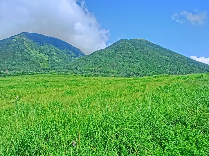
Mount Sanbe live cameras
Mount Sanbe hiking routes
- Mount Osanbe Himenogaike Course Out-and-Back 4.6 km · Ascent 539 m 姫逃池登山口 (parking)
- Mount Osanbe Out-and-Back via Nishinohara 6.0 km · Ascent 662 m 西の原登山口 (parking)
- Sanbe Caldera Rim Circuit from Higashi-no-hara 9.6 km · Ascent 924 m 三瓶観光リフト (Aerialway station) (parking)
Hiking times are estimates calculated from the terrain.
Huts, campsites and lodging near Mount Sanbe
Mountain huts
Campsites
- 三瓶山北の原キャンプ場
Lodging
- 国民宿舎さんべ荘
Lists that include Mount Sanbe
Japan 200 Famous Mountains · Japan's 300 Famous Mountains · 100 Famous Mountains with First-order Triangulation Points · New Japan 100 Famous Mountains · 100 Low Mountains of Japan · 100 Famous Hot Spring Mountains · 100 Fujis of Japan · Chugoku 100 Famous Mountains · Elevations of 1003 Mountains of Japan · 1000 Mountains of Japan
Mount Sanbe facts
- Also known as
- Sanbesan
- Elevation
- 1,126 m
- Location
- Ōda-shi, Shimane
35.140555, 132.621621 - National Park
- 大山隠岐国立公園
- Volcano
- Active volcano (三瓶山)
- Website
- www.sanbesan.jp
- Trail Map
- www.sanbesan.jp (PDF)
- Access Information
- www.kankou-shimane.com
- Wikipedia
- ja.wikipedia.org