
Mount Ōkue
大崩山
Nobeoka, Miyazaki · Elevation 1,644 m
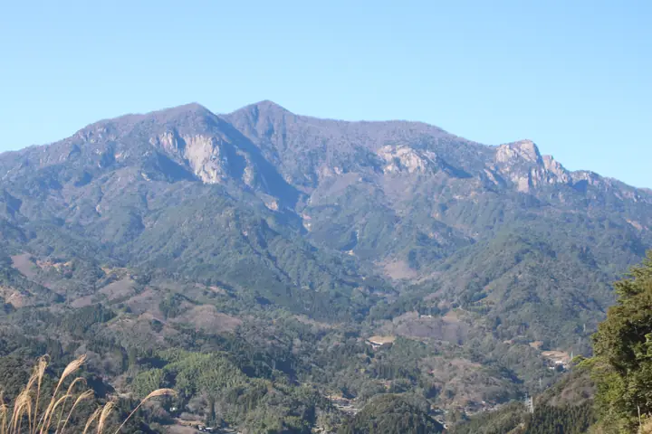
Mount Ōkue is a 1,644 m peak in Nobeoka City, Miyazaki Prefecture, sitting in the eastern Kyūshū mountains within Sobo-Katamuki Quasi-National Park as a granitic cluster of crags often called "Kyūshū's last frontier." The wider Sobo–Katamuki–Ōkue area is also registered as a UNESCO Biosphere Reserve. The peak carries a first-order triangulation marker and is listed in the Nihon Nihyaku Meizan, the Ittō-Sankakuten Hyakumeizan, the Kyūshū Hyakumeizan, and the Miyazaki Hyakuzan. The signature features are the great rock walls of Kotsumi-daki, Zō-iwa, and the Bōzu Ridge, together with the old-growth tsuga, beech, and oak forest at the headwaters of the Hōri River; in spring akebono-tsutsuji azaleas form a celebrated "flower tunnel." The standard ascent loops from the Hōrigawa trailhead via the Wakizuka Ridge and the Bōzu Ridge — a long, exposed, chain-and-ladder route that is regarded as expert-grade.
Mount Ōkue at a glance
- Weather: The most settled day in the next 7 days is Sun, November 8: clear, gusts up to 6 m/s.
- Route: The shortest is Mount Okue Loop via Wakuzuka and Bōzu Ridges: about 6 h 36 min, 9.8 km, about 1,080 m of climbing.
Mount Ōkue weather (hourly, 14 days)
Sunrise today 06:33, sunset 17:23
| Tue, 11/3 | Wed, 11/4 | Thu, 11/5 | Fri, 11/6 | Sat, 11/7 | Sun, 11/8 | Mon, 11/9 | Tue, 11/10 | Wed, 11/11 | Thu, 11/12 | Fri, 11/13 | Sat, 11/14 | Sun, 11/15 | Mon, 11/16 | Tue, 11/17 | |||||||||||||||||||||||||||||||||||||||||||||||||||||||||||||||||||||||
|---|---|---|---|---|---|---|---|---|---|---|---|---|---|---|---|---|---|---|---|---|---|---|---|---|---|---|---|---|---|---|---|---|---|---|---|---|---|---|---|---|---|---|---|---|---|---|---|---|---|---|---|---|---|---|---|---|---|---|---|---|---|---|---|---|---|---|---|---|---|---|---|---|---|---|---|---|---|---|---|---|---|---|---|---|---|
| Japan time | 15 | 17 | 19 | 21 | 23 | 1 | 3 | 5 | 7 | 9 | 11 | 13 | 15 | 18 | 21 | 0 | 3 | 6 | 9 | 12 | 15 | 18 | 21 | 0 | 3 | 6 | 9 | 12 | 15 | 18 | 21 | 0 | 3 | 6 | 9 | 12 | 15 | 18 | 21 | 0 | 3 | 6 | 9 | 12 | 15 | 18 | 21 | 0 | 3 | 6 | 9 | 15 | 21 | 3 | 9 | 15 | 21 | 3 | 9 | 15 | 21 | 3 | 9 | 15 | 21 | 3 | 9 | 15 | 21 | 3 | 9 | 15 | 21 | 3 | 9 | 15 | 21 | 3 | 9 | 15 | 21 | 3 | 9 | 15 | |
 |   |   |   | |   | | |   | |   | |   |   | | | | | | | | | | | |  | | | | | | | | | | | | | | | | | | | | | | | | | | |   | | | | | |   | | | | | |  | | | | | | | | | | | |   | | | |  | | | | ||
| Temperature | °C | 9° | 7° | 5° | 5° | 5° | 4° | 5° | 5° | 5° | 7° | 10° | 11° | 10° | 8° | 7° | 6° | 7° | 7° | 10° | 14° | 13° | 10° | 10° | 10° | 8° | 6° | 8° | 12° | 11° | 5° | 2° | 0° | -2° | -3° | 2° | 7° | 7° | 1° | -1° | -1° | -1° | -1° | 5° | 8° | 7° | 4° | 3° | 2° | 4° | 4° | 6° | 9° | 2° | 0° | 4° | 8° | 0° | 0° | 1° | 5° | -1° | -1° | 4° | 8° | 1° | 0° | 5° | 7° | 2° | 1° | 6° | 9° | 5° | 5° | 8° | 9° | 8° | 9° | 9° | 12° | 4° | 3° | 4° | 8° |
| Precipitation | mm | 0.3 | 0.1 | 1.1 | 1.1 | 0.3 | 0.2 | 0.2 | 0.8 | 7 | 6 | 0.2 | |||||||||||||||||||||||||||||||||||||||||||||||||||||||||||||||||||||||||
| New snow | cm | ||||||||||||||||||||||||||||||||||||||||||||||||||||||||||||||||||||||||||||||||||||
| Snow depth | cm | 0 | 0 | 0 | 0 | 0 | 0 | 0 | 0 | 0 | 0 | 0 | 0 | 0 | 0 | 0 | 0 | 0 | 0 | 0 | 0 | 0 | 0 | 0 | 0 | 0 | 0 | 0 | 0 | 0 | 0 | 0 | 0 | 0 | 0 | 0 | 0 | 0 | 0 | 0 | 0 | 0 | 0 | 0 | 0 | 0 | 0 | 0 | 0 | 0 | 0 | 0 | 0 | 0 | 0 | 0 | 0 | 0 | 0 | 0 | 0 | 0 | 0 | 0 | 0 | 0 | 0 | 0 | 0 | 0 | 0 | 0 | 0 | 0 | 0 | 0 | 0 | 0 | 0 | 0 | 0 | 0 | 0 | 0 | 0 |
| Wind | m/s | 4 | 3 | 3 | 2 | 2 | 2 | 2 | 2 | 2 | 2 | 1 | 3 | 3 | 0 | 1 | 1 | 1 | 1 | 1 | 3 | 3 | 1 | 1 | 2 | 2 | 2 | 3 | 4 | 4 | 3 | 4 | 3 | 2 | 2 | 2 | 3 | 3 | 2 | 2 | 2 | 2 | 2 | 1 | 1 | 1 | 1 | 1 | 1 | 1 | 2 | 3 | 3 | 2 | 2 | 3 | 4 | 3 | 4 | 5 | 3 | 2 | 1 | 1 | 0 | 1 | 2 | 3 | 3 | 2 | 2 | 0 | 2 | 1 | 2 | 4 | 3 | 1 | 3 | 3 | 4 | 2 | 3 | 3 | 2 |
| Wind gusts | m/s | 11 | 11 | 10 | 9 | 8 | 7 | 8 | 7 | 7 | 7 | 6 | 8 | 8 | 8 | 4 | 3 | 4 | 3 | 5 | 10 | 10 | 9 | 8 | 10 | 10 | 10 | 10 | 14 | 14 | 12 | 14 | 14 | 14 | 11 | 10 | 10 | 10 | 10 | 8 | 7 | 6 | 6 | 6 | 6 | 6 | 5 | 5 | 5 | 5 | 7 | 9 | 11 | 10 | 8 | 10 | 12 | 12 | 14 | 15 | 14 | 10 | 6 | 5 | 5 | 5 | 8 | 10 | 11 | 10 | 6 | 6 | 10 | 8 | 7 | 13 | 16 | 12 | 11 | 12 | 12 | 11 | 8 | 9 | 9 |
| Wind dir. | ↓ | ↓ | ↓ | ↓ | ↓ | ↓ | ↓ | ↓ | ↓ | ↓ | ↓ | ↓ | ↓ | ↓ | ↓ | ↓ | ↓ | ↓ | ↓ | ↓ | ↓ | ↓ | ↓ | ↓ | ↓ | ↓ | ↓ | ↓ | ↓ | ↓ | ↓ | ↓ | ↓ | ↓ | ↓ | ↓ | ↓ | ↓ | ↓ | ↓ | ↓ | ↓ | ↓ | ↓ | ↓ | ↓ | ↓ | ↓ | ↓ | ↓ | ↓ | ↓ | ↓ | ↓ | ↓ | ↓ | ↓ | ↓ | ↓ | ↓ | ↓ | ↓ | ↓ | ↓ | ↓ | ↓ | ↓ | ↓ | ↓ | ↓ | ↓ | ↓ | ↓ | ↓ | ↓ | ↓ | ↓ | ↓ | ↓ | ↓ | ↓ | ↓ | ↓ | ↓ | |
Mount Ōkue hiking routes
Hiking times are estimates calculated from the terrain.
Huts, campsites and lodging near Mount Ōkue
Mountain huts
Campsites
- 鹿川キャンプ場
Lists that include Mount Ōkue
Japan 200 Famous Mountains · Japan's 300 Famous Mountains · 100 Famous Mountains with First-order Triangulation Points · Kyushu 100 Famous Mountains · 100 Mountains of Miyazaki · Elevations of 1003 Mountains of Japan · 1000 Mountains of Japan
Mount Ōkue facts
- Elevation
- 1,644 m
- Location
- Nobeoka, Miyazaki
32.737770, 131.513085 - National Park
- 祖母傾国定公園
- Website
- www.city.nobeoka.miyazaki.jp
- Trail Map
- www.city.nobeoka.miyazaki.jp (PDF)
- Access Information
- www.kanko-miyazaki.jp
- Wikipedia
- ja.wikipedia.org