
Mount Ōkue
大崩山
โนเบโอกะ, มิยาซากิ · ความสูง 1,644 ม.
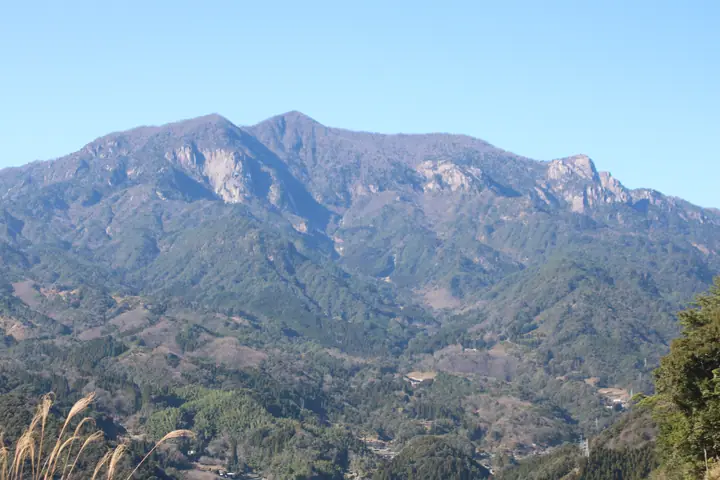
Mount Ōkue is a 1,644 m peak in Nobeoka City, Miyazaki Prefecture, sitting in the eastern Kyūshū mountains within Sobo-Katamuki Quasi-National Park as a granitic cluster of crags often called "Kyūshū's last frontier." The wider Sobo–Katamuki–Ōkue area is also registered as a UNESCO Biosphere Reserve. The peak carries a first-order triangulation marker and is listed in the Nihon Nihyaku Meizan, the Ittō-Sankakuten Hyakumeizan, the Kyūshū Hyakumeizan, and the Miyazaki Hyakuzan. The signature features are the great rock walls of Kotsumi-daki, Zō-iwa, and the Bōzu Ridge, together with the old-growth tsuga, beech, and oak forest at the headwaters of the Hōri River; in spring akebono-tsutsuji azaleas form a celebrated "flower tunnel." The standard ascent loops from the Hōrigawa trailhead via the Wakizuka Ridge and the Bōzu Ridge — a long, exposed, chain-and-ladder route that is regarded as expert-grade.
สรุป Mount Ōkue
- อากาศ: วันที่อากาศคงที่ที่สุดใน 7 วันข้างหน้าคือ อาทิตย์ 8 พฤศจิกายน: ท้องฟ้าแจ่มใส ลมกระโชกสูงสุด 6 ม./วินาที
- เส้นทาง: เส้นทางที่สั้นที่สุดคือ Mount Okue Loop via Wakuzuka and Bōzu Ridges: ประมาณ 6 ชม. 36 นาที 9.8 km ขึ้นประมาณ 1,080 m
อากาศ Mount Ōkue (รายชั่วโมง 2 สัปดาห์)
วันนี้พระอาทิตย์ขึ้น 06:33 ตก 17:23
| อังคาร 3/11 | พุธ 4/11 | พฤหัส 5/11 | ศุกร์ 6/11 | เสาร์ 7/11 | อาทิตย์ 8/11 | จันทร์ 9/11 | อังคาร 10/11 | พุธ 11/11 | พฤหัส 12/11 | ศุกร์ 13/11 | เสาร์ 14/11 | อาทิตย์ 15/11 | จันทร์ 16/11 | อังคาร 17/11 | |||||||||||||||||||||||||||||||||||||||||||||||||||||||||||||||||||||
|---|---|---|---|---|---|---|---|---|---|---|---|---|---|---|---|---|---|---|---|---|---|---|---|---|---|---|---|---|---|---|---|---|---|---|---|---|---|---|---|---|---|---|---|---|---|---|---|---|---|---|---|---|---|---|---|---|---|---|---|---|---|---|---|---|---|---|---|---|---|---|---|---|---|---|---|---|---|---|---|---|---|---|---|
| เวลาญี่ปุ่น | 21 | 23 | 1 | 3 | 5 | 7 | 9 | 11 | 13 | 15 | 17 | 19 | 21 | 0 | 3 | 6 | 9 | 12 | 15 | 18 | 21 | 0 | 3 | 6 | 9 | 12 | 15 | 18 | 21 | 0 | 3 | 6 | 9 | 12 | 15 | 18 | 21 | 0 | 3 | 6 | 9 | 12 | 15 | 18 | 21 | 0 | 3 | 6 | 9 | 15 | 21 | 3 | 9 | 15 | 21 | 3 | 9 | 15 | 21 | 3 | 9 | 15 | 21 | 3 | 9 | 15 | 21 | 3 | 9 | 15 | 21 | 3 | 9 | 15 | 21 | 3 | 9 | 15 | 21 | 3 | 9 | 15 | |
  |   |   | | |   | | | |   | | | |   | | |   | | | | | | |  |   | |  | | | | | | | | | | | | | | |   | | | | | | | | |   | | | | | | | | | | | |  | | | | | | | | | | | |   | | | |  | | | | ||
| อุณหภูมิ | °C | 5° | 5° | 5° | 5° | 5° | 5° | 8° | 9° | 10° | 9° | 8° | 7° | 6° | 6° | 7° | 9° | 11° | 14° | 13° | 10° | 10° | 10° | 8° | 6° | 8° | 12° | 11° | 5° | 2° | 0° | -2° | -3° | 2° | 7° | 7° | 1° | -1° | -1° | -1° | -1° | 5° | 8° | 7° | 4° | 3° | 2° | 4° | 4° | 6° | 9° | 2° | 0° | 4° | 8° | 0° | 0° | 1° | 5° | -1° | -1° | 4° | 8° | 1° | 0° | 5° | 7° | 2° | 1° | 6° | 9° | 5° | 5° | 8° | 9° | 8° | 9° | 9° | 12° | 4° | 3° | 4° | 8° |
| ฝนและหิมะ | mm | 0.2 | 0.3 | 0.2 | 0.3 | 1.9 | 1.0 | 0.3 | 0.2 | 0.2 | 0.8 | 7 | 6 | 0.2 | |||||||||||||||||||||||||||||||||||||||||||||||||||||||||||||||||||||
| หิมะตก | cm | – | – | ||||||||||||||||||||||||||||||||||||||||||||||||||||||||||||||||||||||||||||||||
| หิมะสะสม | cm | 0 | 0 | 0 | 0 | 0 | 0 | 0 | 0 | 0 | 0 | 0 | 0 | 0 | 0 | 0 | 0 | 0 | 0 | 0 | 0 | 0 | 0 | 0 | 0 | 0 | 0 | 0 | 0 | 0 | 0 | 0 | 0 | 0 | 0 | 0 | 0 | 0 | 0 | 0 | 0 | 0 | 0 | 0 | 0 | 0 | 0 | 0 | 0 | 0 | 0 | 0 | 0 | 0 | 0 | 0 | 0 | 0 | 0 | 0 | 0 | 0 | 0 | 0 | 0 | 0 | 0 | 0 | 0 | 0 | 0 | 0 | 0 | 0 | 0 | 0 | 0 | 0 | 0 | 0 | 0 | 0 | 0 |
| ลม | m/s | 2 | 2 | 2 | 2 | 2 | 2 | 2 | 1 | 2 | 3 | 1 | 0 | 1 | 1 | 2 | 1 | 1 | 3 | 3 | 1 | 1 | 2 | 2 | 2 | 3 | 4 | 4 | 3 | 4 | 3 | 2 | 2 | 2 | 3 | 3 | 2 | 2 | 2 | 2 | 2 | 1 | 1 | 1 | 1 | 1 | 1 | 1 | 2 | 3 | 3 | 2 | 2 | 3 | 4 | 3 | 4 | 5 | 3 | 2 | 1 | 1 | 0 | 1 | 2 | 3 | 3 | 2 | 2 | 0 | 2 | 1 | 2 | 4 | 3 | 1 | 3 | 3 | 4 | 2 | 3 | 3 | 2 |
| ลมกระโชก | m/s | 9 | 8 | 7 | 7 | 7 | 7 | 6 | 6 | 7 | 8 | 7 | 3 | 2 | 4 | 4 | 4 | 6 | 10 | 11 | 9 | 8 | 10 | 10 | 10 | 10 | 14 | 14 | 12 | 14 | 14 | 14 | 11 | 10 | 10 | 10 | 10 | 8 | 7 | 6 | 6 | 6 | 6 | 6 | 5 | 5 | 5 | 5 | 7 | 9 | 11 | 10 | 8 | 10 | 12 | 12 | 14 | 15 | 14 | 10 | 6 | 5 | 5 | 5 | 8 | 10 | 11 | 10 | 6 | 6 | 10 | 8 | 7 | 13 | 16 | 12 | 11 | 12 | 12 | 11 | 8 | 9 | 9 |
| ทิศทางลม | ↓ | ↓ | ↓ | ↓ | ↓ | ↓ | ↓ | ↓ | ↓ | ↓ | ↓ | ↓ | ↓ | ↓ | ↓ | ↓ | ↓ | ↓ | ↓ | ↓ | ↓ | ↓ | ↓ | ↓ | ↓ | ↓ | ↓ | ↓ | ↓ | ↓ | ↓ | ↓ | ↓ | ↓ | ↓ | ↓ | ↓ | ↓ | ↓ | ↓ | ↓ | ↓ | ↓ | ↓ | ↓ | ↓ | ↓ | ↓ | ↓ | ↓ | ↓ | ↓ | ↓ | ↓ | ↓ | ↓ | ↓ | ↓ | ↓ | ↓ | ↓ | ↓ | ↓ | ↓ | ↓ | ↓ | ↓ | ↓ | ↓ | ↓ | ↓ | ↓ | ↓ | ↓ | ↓ | ↓ | ↓ | ↓ | ↓ | ↓ | ↓ | ↓ | |
เส้นทางเดินป่า Mount Ōkue
เวลาเดินเป็นค่าประมาณที่คำนวณจากภูมิประเทศ
กระท่อม ที่ตั้งแคมป์ และที่พักใกล้ Mount Ōkue
กระท่อมบนภูเขา
ที่ตั้งแคมป์
- 鹿川キャンプ場
รายชื่อที่มี Mount Ōkue
200 ภูเขาที่มีชื่อเสียงของญี่ปุ่น · 300 ภูเขาที่มีชื่อเสียงของญี่ปุ่น · 100 ภูเขาที่มีชื่อเสียงซึ่งมีหมุดสามเหลี่ยมชั้นหนึ่ง · 100 ภูเขาที่มีชื่อเสียงของคิวชู · ภูเขา 100 แห่งของมิยาซากิ · ระดับความสูงของภูเขา 1003 แห่งในญี่ปุ่น · ภูเขา 1000 แห่งของญี่ปุ่น
ข้อมูลพื้นฐาน Mount Ōkue
- ความสูง
- 1,644 ม.
- ที่ตั้ง
- โนเบโอกะ, มิยาซากิ
32.737770, 131.513085 - อุทยานแห่งชาติ
- 祖母傾国定公園
- เว็บไซต์
- www.city.nobeoka.miyazaki.jp
- แผนที่เส้นทางเดินเขา
- www.city.nobeoka.miyazaki.jp (PDF)
- ข้อมูลการเดินทาง
- www.kanko-miyazaki.jp
- วิกิพีเดีย
- ja.wikipedia.org