
Mount Kyō
経ヶ岳
Tatsuno, Nagano / Minamiminowa, Nagano · Elevation 2,296 m
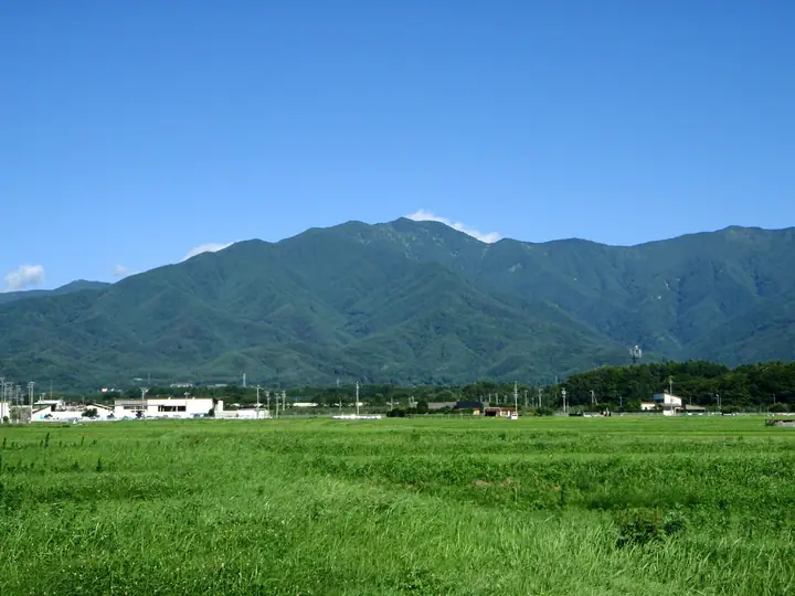
Mount Kyō is a 2,296 m peak straddling Ina City and Minami-Minowa Village (Kami-Ina District) in Nagano Prefecture, marking the northern end of the Kiso Range (Central Japanese Alps). The name derives from the kyōzuka sutra mounds and stone Buddhas enshrined on the summit, reflecting its long history as an object of mountain worship; it is listed in the Nihon Nihyaku Meizan and the Shinshū Hyakumeizan. Above the long forested approach the Koinoko viewpoint at the eighth station opens onto a panorama of the Ina Valley, the Southern Alps, and Yatsugatake, with Mount Ontake to the west and the Central Alps' Komaga-take and Hōken-dake to the south. Three main trails serve the peak — from Chūsen-ji at Hahiro on the Ina side (about eight hours round trip), from the Ōizumi-sho dam on the Minami-Minowa side, and from Gonbei Pass — all decorated in season with sasayuri lilies, ayame, and fireweed.
Mount Kyō at a glance
- Weather: The most settled day in the next 7 days is Wed, November 4: clear, gusts up to 5 m/s.
Mount Kyō weather (hourly, 14 days)
Sunrise today 06:12, sunset 16:52
| Tue, 11/3 | Wed, 11/4 | Thu, 11/5 | Fri, 11/6 | Sat, 11/7 | Sun, 11/8 | Mon, 11/9 | Tue, 11/10 | Wed, 11/11 | Thu, 11/12 | Fri, 11/13 | Sat, 11/14 | Sun, 11/15 | Mon, 11/16 | Tue, 11/17 | |||||||||||||||||||||||||||||||||||||||||||||||||||||||||||||||||||||||
|---|---|---|---|---|---|---|---|---|---|---|---|---|---|---|---|---|---|---|---|---|---|---|---|---|---|---|---|---|---|---|---|---|---|---|---|---|---|---|---|---|---|---|---|---|---|---|---|---|---|---|---|---|---|---|---|---|---|---|---|---|---|---|---|---|---|---|---|---|---|---|---|---|---|---|---|---|---|---|---|---|---|---|---|---|---|
| Japan time | 15 | 17 | 19 | 21 | 23 | 1 | 3 | 5 | 7 | 9 | 11 | 13 | 15 | 18 | 21 | 0 | 3 | 6 | 9 | 12 | 15 | 18 | 21 | 0 | 3 | 6 | 9 | 12 | 15 | 18 | 21 | 0 | 3 | 6 | 9 | 12 | 15 | 18 | 21 | 0 | 3 | 6 | 9 | 12 | 15 | 18 | 21 | 0 | 3 | 6 | 9 | 15 | 21 | 3 | 9 | 15 | 21 | 3 | 9 | 15 | 21 | 3 | 9 | 15 | 21 | 3 | 9 | 15 | 21 | 3 | 9 | 15 | 21 | 3 | 9 | 15 | 21 | 3 | 9 | 15 | 21 | 3 | 9 | 15 | |
  |   |  | | | | | | | |  | |   |   | |   | | |   |   |   | |   | | |   | | | | | | | | |   | | |  | | | | | | | | | | | | | | | |   | | | |   |   | | | | | |  | | | | | | | | | | | | | | | | | | | | ||
| Temperature | °C | 7° | 1° | -1° | -4° | -5° | -4° | -4° | -4° | -3° | 3° | 6° | 9° | 9° | 3° | 2° | 1° | 1° | 1° | 3° | 7° | 7° | 3° | 3° | 2° | 2° | 2° | 6° | 10° | 7° | 2° | -1° | -2° | -3° | -5° | 0° | 2° | 0° | -5° | -7° | -8° | -9° | -10° | 0° | 5° | 5° | -2° | -3° | -3° | -2° | -2° | 2° | 5° | -4° | -6° | 1° | 2° | -3° | -5° | -4° | 0° | -8° | -11° | -1° | 3° | -8° | -5° | 0° | 2° | -7° | -10° | -1° | 4° | -3° | -5° | 2° | 5° | 2° | 1° | 6° | 6° | -3° | -5° | -2° | 5° |
| Precipitation | mm | 3.1 | 15 | 2.5 | 1.8 | 0.2 | 0.2 | 0.6 | 0.1 | 0.1 | 0.3 | 0.1 | 11 | 13 | 0.1 | 0.6 | |||||||||||||||||||||||||||||||||||||||||||||||||||||||||||||||||||||
| New snow | cm | 0.1 | 0.1 | ||||||||||||||||||||||||||||||||||||||||||||||||||||||||||||||||||||||||||||||||||
| Snow depth | cm | 0 | 0 | 0 | 0 | 0 | 0 | 0 | 0 | 0 | 0 | 0 | 0 | 0 | 0 | 0 | 0 | 0 | 0 | 0 | 0 | 0 | 0 | 0 | 0 | 0 | 0 | 0 | 0 | 0 | 0 | 0 | 0 | 0 | 0 | 0 | 0 | 0 | 0 | 0 | 0 | 0 | 0 | 0 | 0 | 0 | 0 | 0 | 0 | 0 | 0 | 0 | 0 | 0 | 0 | 0 | 0 | 0 | 0 | 0 | 0 | 0 | 0 | 0 | 0 | 0 | 0 | 0 | 0 | 0 | 0 | 0 | 0 | 0 | 0 | 0 | 0 | 0 | 0 | 0 | 0 | 0 | 0 | 0 | 0 |
| Wind | m/s | 2 | 1 | 1 | 1 | 1 | 1 | 0 | 0 | 0 | 1 | 1 | 1 | 1 | 1 | 2 | 2 | 1 | 1 | 0 | 1 | 2 | 2 | 2 | 2 | 2 | 2 | 2 | 5 | 5 | 3 | 2 | 2 | 2 | 3 | 4 | 4 | 3 | 2 | 2 | 2 | 2 | 0 | 0 | 1 | 2 | 1 | 1 | 2 | 2 | 2 | 2 | 2 | 1 | 0 | 1 | 5 | 4 | 5 | 1 | 2 | 0 | 2 | 2 | 4 | 1 | 3 | 1 | 2 | 1 | 1 | 2 | 4 | 3 | 3 | 2 | 2 | 2 | 3 | 3 | 4 | 1 | 1 | 0 | 2 |
| Wind gusts | m/s | 7 | 7 | 4 | 4 | 4 | 4 | 4 | 3 | 3 | 3 | 4 | 5 | 5 | 3 | 4 | 5 | 6 | 9 | 7 | 7 | 8 | 8 | 8 | 8 | 10 | 11 | 9 | 14 | 15 | 14 | 10 | 10 | 10 | 10 | 14 | 15 | 14 | 12 | 9 | 8 | 7 | 7 | 4 | 4 | 6 | 6 | 5 | 7 | 8 | 9 | 9 | 12 | 8 | 3 | 6 | 17 | 16 | 16 | 17 | 9 | 8 | 6 | 7 | 13 | 11 | 9 | 9 | 7 | 7 | 5 | 6 | 12 | 11 | 9 | 9 | 15 | 11 | 13 | 12 | 13 | 12 | 5 | 3 | 8 |
| Wind dir. | ↓ | ↓ | ↓ | ↓ | ↓ | ↓ | ↓ | ↓ | ↓ | ↓ | ↓ | ↓ | ↓ | ↓ | ↓ | ↓ | ↓ | ↓ | ↓ | ↓ | ↓ | ↓ | ↓ | ↓ | ↓ | ↓ | ↓ | ↓ | ↓ | ↓ | ↓ | ↓ | ↓ | ↓ | ↓ | ↓ | ↓ | ↓ | ↓ | ↓ | ↓ | ↓ | ↓ | ↓ | ↓ | ↓ | ↓ | ↓ | ↓ | ↓ | ↓ | ↓ | ↓ | ↓ | ↓ | ↓ | ↓ | ↓ | ↓ | ↓ | ↓ | ↓ | ↓ | ↓ | ↓ | ↓ | ↓ | ↓ | ↓ | ↓ | ↓ | ↓ | ↓ | ↓ | ↓ | ↓ | ↓ | ↓ | ↓ | ↓ | ↓ | ↓ | ↓ | ↓ | |
Lists that include Mount Kyō
Japan 200 Famous Mountains · Japan's 300 Famous Mountains · Koshinetsu 100 Famous Mountains · Shinshu 100 Famous Mountains · Shinshu Mountain Cards · Elevations of 1003 Mountains of Japan · 1000 Mountains of Japan
Mount Kyō facts
- Elevation
- 2,296 m
- Location
- Tatsuno, Nagano / Minamiminowa, Nagano
35.912845, 137.862636 - Website
- www.vill.minamiminowa.lg.jp
- Trail Map
- www.vill.minamiminowa.lg.jp (PDF)
- Access Information
- www.vill.minamiminowa.lg.jp
- Wikipedia
- ja.wikipedia.org