
Mount Kogashi
古賀志山
Utsunomiya, Tochigi · Elevation 583 m
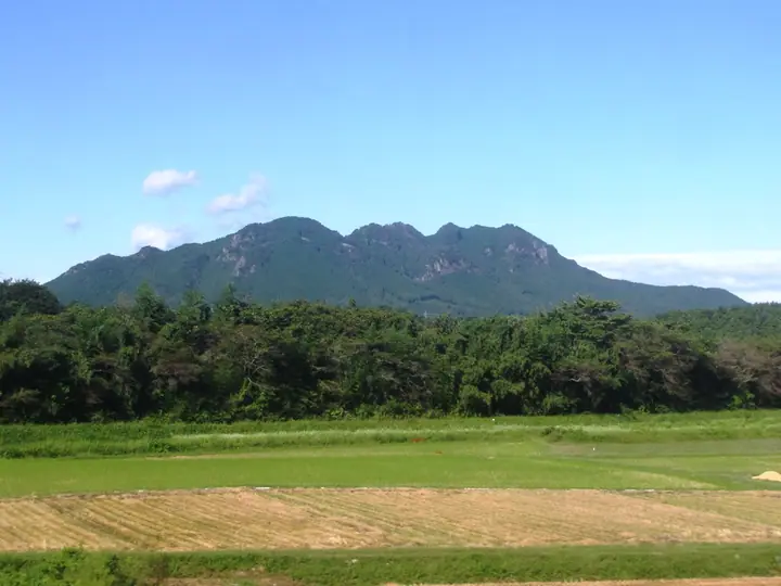
Mount Kogashi (582.8 m) stands in the north-western outskirts of Utsunomiya, Tochigi Prefecture, marking the south-eastern edge of the Ashio mountain range and serving as a striking foothill of the Nikkō massif. Its long east–west ridge takes in the rocky satellite peaks of Ontake-san and Akaiwa-san, drawing climbers and paragliders to its crags. A network of trails radiates from Utsunomiya Forest Park at its base, and the slopes are renowned for spring katakuri (dogtooth violet) blooms. The peak is counted among the Kantō Hyakumeizan, Tochigi Hyakumeizan, and the Hundred Low Mountains of Japan.
Mount Kogashi at a glance
- Weather: The most settled day in the next 7 days is Fri, November 6: clear, gusts up to 6 m/s.
- Route: The shortest is Mount Kogashi and Mount Mitake North–South Circuit: about 3 h 12 min, 6.8 km, about 430 m of climbing.
Mount Kogashi weather (hourly, 14 days)
Sunrise today 06:06, sunset 16:44
| Tue, 11/3 | Wed, 11/4 | Thu, 11/5 | Fri, 11/6 | Sat, 11/7 | Sun, 11/8 | Mon, 11/9 | Tue, 11/10 | Wed, 11/11 | Thu, 11/12 | Fri, 11/13 | Sat, 11/14 | Sun, 11/15 | Mon, 11/16 | Tue, 11/17 | |||||||||||||||||||||||||||||||||||||||||||||||||||||||||||||||||||||||
|---|---|---|---|---|---|---|---|---|---|---|---|---|---|---|---|---|---|---|---|---|---|---|---|---|---|---|---|---|---|---|---|---|---|---|---|---|---|---|---|---|---|---|---|---|---|---|---|---|---|---|---|---|---|---|---|---|---|---|---|---|---|---|---|---|---|---|---|---|---|---|---|---|---|---|---|---|---|---|---|---|---|---|---|---|---|
| Japan time | 15 | 17 | 19 | 21 | 23 | 1 | 3 | 5 | 7 | 9 | 11 | 13 | 15 | 18 | 21 | 0 | 3 | 6 | 9 | 12 | 15 | 18 | 21 | 0 | 3 | 6 | 9 | 12 | 15 | 18 | 21 | 0 | 3 | 6 | 9 | 12 | 15 | 18 | 21 | 0 | 3 | 6 | 9 | 12 | 15 | 18 | 21 | 0 | 3 | 6 | 9 | 15 | 21 | 3 | 9 | 15 | 21 | 3 | 9 | 15 | 21 | 3 | 9 | 15 | 21 | 3 | 9 | 15 | 21 | 3 | 9 | 15 | 21 | 3 | 9 | 15 | 21 | 3 | 9 | 15 | 21 | 3 | 9 | 15 | |
  |   |   | | | | | |  | | |   |   |   | |   | | |   |   | |   | | |  | | | |   | | | | | | | | | | | | | | | | | | | | | | | | | | | | | | | | |  | | | | | | | | | | | | | | | |   | | | | | | | ||
| Temperature | °C | 14° | 11° | 9° | 8° | 8° | 6° | 6° | 5° | 6° | 11° | 13° | 13° | 11° | 10° | 10° | 8° | 9° | 10° | 11° | 15° | 14° | 11° | 10° | 10° | 9° | 9° | 14° | 18° | 18° | 12° | 10° | 9° | 7° | 6° | 11° | 13° | 12° | 6° | 5° | 3° | 3° | 2° | 8° | 11° | 11° | 6° | 5° | 5° | 5° | 5° | 6° | 10° | 7° | 5° | 7° | 10° | 4° | 1° | 7° | 10° | 6° | 3° | 8° | 10° | 6° | 4° | 10° | 10° | 4° | 1° | 6° | 9° | 3° | 1° | 8° | 12° | 9° | 8° | 12° | 17° | 7° | 3° | 6° | 9° |
| Precipitation | mm | 1.8 | 8 | 11 | 8 | 0.5 | 0.1 | 0.5 | 0.1 | 0.3 | 0.4 | 0.9 | 0.3 | 2.8 | 4.3 | 10 | 0.2 | ||||||||||||||||||||||||||||||||||||||||||||||||||||||||||||||||||||
| New snow | cm | ||||||||||||||||||||||||||||||||||||||||||||||||||||||||||||||||||||||||||||||||||||
| Snow depth | cm | 0 | 0 | 0 | 0 | 0 | 0 | 0 | 0 | 0 | 0 | 0 | 0 | 0 | 0 | 0 | 0 | 0 | 0 | 0 | 0 | 0 | 0 | 0 | 0 | 0 | 0 | 0 | 0 | 0 | 0 | 0 | 0 | 0 | 0 | 0 | 0 | 0 | 0 | 0 | 0 | 0 | 0 | 0 | 0 | 0 | 0 | 0 | 0 | 0 | 0 | 0 | 0 | 0 | 0 | 0 | 0 | 0 | 0 | 0 | 0 | 0 | 0 | 0 | 0 | 0 | 0 | 0 | 0 | 0 | 0 | 0 | 0 | 0 | 0 | 0 | 0 | 0 | 0 | 0 | 0 | 0 | 0 | 0 | 0 |
| Wind | m/s | 3 | 0 | 0 | 0 | 1 | 0 | 1 | 1 | 1 | 1 | 2 | 2 | 2 | 2 | 2 | 2 | 2 | 3 | 3 | 2 | 1 | 0 | 0 | 0 | 1 | 0 | 1 | 1 | 2 | 1 | 2 | 2 | 0 | 0 | 2 | 2 | 2 | 1 | 0 | 1 | 1 | 1 | 1 | 3 | 2 | 0 | 1 | 1 | 1 | 1 | 1 | 1 | 0 | 0 | 1 | 3 | 0 | 2 | 3 | 1 | 2 | 0 | 1 | 0 | 0 | 1 | 2 | 5 | 3 | 1 | 2 | 2 | 1 | 1 | 1 | 2 | 1 | 1 | 1 | 4 | 3 | 1 | 0 | 1 |
| Wind gusts | m/s | 7 | 6 | 1 | 1 | 2 | 2 | 1 | 2 | 1 | 3 | 5 | 6 | 6 | 5 | 4 | 5 | 5 | 5 | 6 | 6 | 5 | 3 | 1 | 1 | 2 | 2 | 4 | 6 | 5 | 4 | 3 | 5 | 4 | 2 | 5 | 7 | 7 | 5 | 3 | 2 | 2 | 2 | 4 | 8 | 8 | 5 | 2 | 2 | 3 | 3 | 3 | 5 | 3 | 3 | 4 | 6 | 8 | 4 | 7 | 8 | 7 | 4 | 4 | 5 | 4 | 2 | 6 | 11 | 12 | 6 | 5 | 6 | 5 | 3 | 3 | 6 | 4 | 3 | 4 | 8 | 13 | 7 | 4 | 5 |
| Wind dir. | ↓ | ↓ | ↓ | ↓ | ↓ | ↓ | ↓ | ↓ | ↓ | ↓ | ↓ | ↓ | ↓ | ↓ | ↓ | ↓ | ↓ | ↓ | ↓ | ↓ | ↓ | ↓ | ↓ | ↓ | ↓ | ↓ | ↓ | ↓ | ↓ | ↓ | ↓ | ↓ | ↓ | ↓ | ↓ | ↓ | ↓ | ↓ | ↓ | ↓ | ↓ | ↓ | ↓ | ↓ | ↓ | ↓ | ↓ | ↓ | ↓ | ↓ | ↓ | ↓ | ↓ | ↓ | ↓ | ↓ | ↓ | ↓ | ↓ | ↓ | ↓ | ↓ | ↓ | ↓ | ↓ | ↓ | ↓ | ↓ | ↓ | ↓ | ↓ | ↓ | ↓ | ↓ | ↓ | ↓ | ↓ | ↓ | ↓ | ↓ | ↓ | ↓ | ↓ | ↓ | |
Mount Kogashi hiking routes
Hiking times are estimates calculated from the terrain.
Huts, campsites and lodging near Mount Kogashi
Campsites
- ロッキーズ 古賀志山ベース
Lodging
- ホテル鶴
- ニューサンピア栃木
Lists that include Mount Kogashi
100 Low Mountains of Japan · Kanto 100 Famous Mountains · Tochigi 100 Famous Mountains · Oya 7 Famous Mountains
Mount Kogashi facts
- Elevation
- 583 m
- Location
- Utsunomiya, Tochigi
36.621762, 139.771462 - Website
- www.utsunomiya-cvb.org
- Trail Map
- www.utsunomiya-cvb.org
- Wikipedia
- ja.wikipedia.org