
Mount Kirara
雲母峰
Komono, Mie / Yokkaichi, Mie · Elevation 888 m
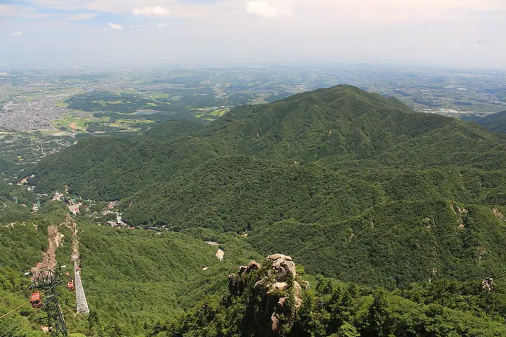
Mt. Kiraramine is an 888.4-meter peak straddling Yokkaichi City and Komono Town in Mie Prefecture, sitting at the end of the long ridge extending east from Mt. Kamagatake on the main Suzuka crest; most of the surrounding area lies within Suzuka Quasi-National Park. Its name comes from the black mica (kira-kira) that was once mined from the valley facing Mizusawa-chō on the Yokkaichi side. The triangulated main summit is enclosed in second-growth forest and lacks views, but the "Kiraramine II Peak" about 300 m to the southeast (~860 m) serves as a paraglider launch with a sweeping outlook over Ise Bay. The standard climb starts from the Kirarahashi trailhead in Yokkaichi City.
Mount Kirara at a glance
- Weather: The most settled day in the next 7 days is Thu, November 5: cloudy, gusts up to 4 m/s. Fri, Nov 6, Sat, Nov 7: strong wind (gusts up to 17 m/s).
- Route: The shortest is Mount Kiraramine and West Peak from Kirarabashi: about 3 h 39 min, 5.6 km, about 690 m of climbing.
Mount Kirara weather (hourly, 14 days)
Sunrise today 06:16, sunset 16:59
| Tue, 11/3 | Wed, 11/4 | Thu, 11/5 | Fri, 11/6 | Sat, 11/7 | Sun, 11/8 | Mon, 11/9 | Tue, 11/10 | Wed, 11/11 | Thu, 11/12 | Fri, 11/13 | Sat, 11/14 | Sun, 11/15 | Mon, 11/16 | Tue, 11/17 | |||||||||||||||||||||||||||||||||||||||||||||||||||||||||||||||||||||||
|---|---|---|---|---|---|---|---|---|---|---|---|---|---|---|---|---|---|---|---|---|---|---|---|---|---|---|---|---|---|---|---|---|---|---|---|---|---|---|---|---|---|---|---|---|---|---|---|---|---|---|---|---|---|---|---|---|---|---|---|---|---|---|---|---|---|---|---|---|---|---|---|---|---|---|---|---|---|---|---|---|---|---|---|---|---|
| Japan time | 15 | 17 | 19 | 21 | 23 | 1 | 3 | 5 | 7 | 9 | 11 | 13 | 15 | 18 | 21 | 0 | 3 | 6 | 9 | 12 | 15 | 18 | 21 | 0 | 3 | 6 | 9 | 12 | 15 | 18 | 21 | 0 | 3 | 6 | 9 | 12 | 15 | 18 | 21 | 0 | 3 | 6 | 9 | 12 | 15 | 18 | 21 | 0 | 3 | 6 | 9 | 15 | 21 | 3 | 9 | 15 | 21 | 3 | 9 | 15 | 21 | 3 | 9 | 15 | 21 | 3 | 9 | 15 | 21 | 3 | 9 | 15 | 21 | 3 | 9 | 15 | 21 | 3 | 9 | 15 | 21 | 3 | 9 | 15 | |
 |   | |  | | | | |   | | |   |   |   | |   | | |   | | |  | | |   | |   | | | | | | | |   | | | | |   | | | | | | | | | | | | | |   | | | | | | | |  | | | | | | | | | | | | | | | | | | | | | | | ||
| Temperature | °C | 14° | 11° | 8° | 7° | 6° | 5° | 6° | 4° | 4° | 11° | 13° | 13° | 12° | 10° | 10° | 10° | 9° | 10° | 13° | 13° | 15° | 11° | 10° | 9° | 10° | 11° | 12° | 16° | 15° | 10° | 8° | 7° | 6° | 5° | 7° | 8° | 7° | 5° | 4° | 4° | 3° | 3° | 8° | 10° | 9° | 6° | 5° | 5° | 5° | 5° | 8° | 11° | 4° | 3° | 9° | 12° | 5° | 3° | 6° | 8° | 3° | 1° | 7° | 9° | 2° | 4° | 8° | 8° | 3° | -1° | 8° | 10° | 5° | 7° | 10° | 10° | 9° | 9° | 12° | 12° | 6° | 4° | 6° | 9° |
| Precipitation | mm | 0.7 | 1.8 | 0.2 | 0.5 | 0.4 | 1.9 | 0.3 | 0.2 | 0.1 | 0.1 | 0.4 | 0.2 | 0.1 | 0.1 | 0.2 | 0.1 | 0.2 | 3.8 | 13 | 0.2 | 0.6 | |||||||||||||||||||||||||||||||||||||||||||||||||||||||||||||||
| New snow | cm | ||||||||||||||||||||||||||||||||||||||||||||||||||||||||||||||||||||||||||||||||||||
| Snow depth | cm | 0 | 0 | 0 | 0 | 0 | 0 | 0 | 0 | 0 | 0 | 0 | 0 | 0 | 0 | 0 | 0 | 0 | 0 | 0 | 0 | 0 | 0 | 0 | 0 | 0 | 0 | 0 | 0 | 0 | 0 | 0 | 0 | 0 | 0 | 0 | 0 | 0 | 0 | 0 | 0 | 0 | 0 | 0 | 0 | 0 | 0 | 0 | 0 | 0 | 0 | 0 | 0 | 0 | 0 | 0 | 0 | 0 | 0 | 0 | 0 | 0 | 0 | 0 | 0 | 0 | 0 | 0 | 0 | 0 | 0 | 0 | 0 | 0 | 0 | 0 | 0 | 0 | 0 | 0 | 0 | 0 | 0 | 0 | 0 |
| Wind | m/s | 4 | 3 | 3 | 3 | 3 | 3 | 2 | 2 | 2 | 0 | 1 | 1 | 1 | 1 | 1 | 1 | 1 | 0 | 1 | 1 | 1 | 0 | 0 | 1 | 2 | 3 | 5 | 7 | 6 | 5 | 5 | 6 | 5 | 4 | 6 | 7 | 6 | 4 | 2 | 2 | 2 | 2 | 4 | 5 | 4 | 3 | 2 | 2 | 2 | 2 | 3 | 3 | 3 | 1 | 1 | 5 | 3 | 6 | 6 | 7 | 3 | 2 | 2 | 4 | 3 | 3 | 4 | 6 | 4 | 3 | 1 | 2 | 1 | 0 | 1 | 1 | 1 | 0 | 4 | 6 | 4 | 5 | 3 | 2 |
| Wind gusts | m/s | 10 | 10 | 9 | 8 | 7 | 7 | 7 | 7 | 6 | 5 | 5 | 5 | 6 | 4 | 6 | 7 | 4 | 3 | 4 | 3 | 3 | 3 | 2 | 3 | 7 | 10 | 14 | 17 | 17 | 15 | 14 | 15 | 15 | 13 | 15 | 17 | 17 | 15 | 10 | 7 | 7 | 7 | 10 | 12 | 13 | 11 | 8 | 5 | 5 | 6 | 8 | 11 | 9 | 6 | 4 | 11 | 11 | 17 | 17 | 19 | 16 | 9 | 8 | 10 | 9 | 9 | 10 | 16 | 15 | 10 | 6 | 7 | 5 | 3 | 5 | 7 | 6 | 7 | 9 | 15 | 14 | 12 | 12 | 9 |
| Wind dir. | ↓ | ↓ | ↓ | ↓ | ↓ | ↓ | ↓ | ↓ | ↓ | ↓ | ↓ | ↓ | ↓ | ↓ | ↓ | ↓ | ↓ | ↓ | ↓ | ↓ | ↓ | ↓ | ↓ | ↓ | ↓ | ↓ | ↓ | ↓ | ↓ | ↓ | ↓ | ↓ | ↓ | ↓ | ↓ | ↓ | ↓ | ↓ | ↓ | ↓ | ↓ | ↓ | ↓ | ↓ | ↓ | ↓ | ↓ | ↓ | ↓ | ↓ | ↓ | ↓ | ↓ | ↓ | ↓ | ↓ | ↓ | ↓ | ↓ | ↓ | ↓ | ↓ | ↓ | ↓ | ↓ | ↓ | ↓ | ↓ | ↓ | ↓ | ↓ | ↓ | ↓ | ↓ | ↓ | ↓ | ↓ | ↓ | ↓ | ↓ | ↓ | ↓ | ↓ | ↓ | |
Mount Kirara hiking routes
Hiking times are estimates calculated from the terrain.
Huts, campsites and lodging near Mount Kirara
Mountain huts
- 日向小屋 reservation required
- 井戸谷避難小屋 unstaffed
- 北尾根避難小屋 unstaffed
- 籐内小屋
- 藤内小屋 reservation required · sleeps 50
Campsites
- 宮妻峡 バンガロー・キャンプ場
- 小岐須渓谷キャンプ場
Lodging
- 三慶園
- 一の谷山荘
- ホテルウェルネス鈴鹿路
- グリーンホテル
- 湯の山温泉 希望荘
Mount Kirara facts
- Also known as
- 吉良良山
- Elevation
- 888 m
- Location
- Komono, Mie / Yokkaichi, Mie
34.999119, 136.448795 - National Park
- 鈴鹿国定公園
- Website
- www.kankomie.or.jp
- Trail Map
- www.city.yokkaichi.lg.jp (PDF)
- Wikipedia
- ja.wikipedia.org