
Mount Kamakura
鎌倉岳
Tamura, Fukushima · Elevation 967 m
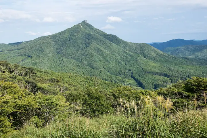
Mount Kamakura is a 967.1 m peak in the Tokiwa district of Tamura City, Fukushima, standing in the central Abukuma Highlands. Its sharp, sky-piercing granite silhouette is unusual in a region of rounded summits, and earns it the nickname "the renegade of the Abukuma." Locally it is distinguished as Tokiwa-Kamakura-dake to set it apart from the like-named peak in Furudono Town. The rocky summit hosts a small stone shrine to Ame-no-Hiwashi, a third-class triangulation point, and a direction plate, with sweeping views of Mount Ōtakine, the Adatara range, and the Azuma range. Spring azaleas and autumn foliage are highlights, and the peak appears in Hana no Hyakumeizan, Tōhoku Hyakumeizan, and Utsukushima Hyakumeizan.
Mount Kamakura at a glance
- Weather: The most settled day in the next 7 days is Wed, November 4: clear, gusts up to 6 m/s. Fri, Nov 6, Sat, Nov 7, Sun, Nov 8: strong wind (gusts up to 19 m/s).
Mount Kamakura weather (hourly, 14 days)
Sunrise today 06:03, sunset 16:38
| Tue, 11/3 | Wed, 11/4 | Thu, 11/5 | Fri, 11/6 | Sat, 11/7 | Sun, 11/8 | Mon, 11/9 | Tue, 11/10 | Wed, 11/11 | Thu, 11/12 | Fri, 11/13 | Sat, 11/14 | Sun, 11/15 | Mon, 11/16 | Tue, 11/17 | |||||||||||||||||||||||||||||||||||||||||||||||||||||||||||||||||||||||
|---|---|---|---|---|---|---|---|---|---|---|---|---|---|---|---|---|---|---|---|---|---|---|---|---|---|---|---|---|---|---|---|---|---|---|---|---|---|---|---|---|---|---|---|---|---|---|---|---|---|---|---|---|---|---|---|---|---|---|---|---|---|---|---|---|---|---|---|---|---|---|---|---|---|---|---|---|---|---|---|---|---|---|---|---|---|
| Japan time | 15 | 17 | 19 | 21 | 23 | 1 | 3 | 5 | 7 | 9 | 11 | 13 | 15 | 18 | 21 | 0 | 3 | 6 | 9 | 12 | 15 | 18 | 21 | 0 | 3 | 6 | 9 | 12 | 15 | 18 | 21 | 0 | 3 | 6 | 9 | 12 | 15 | 18 | 21 | 0 | 3 | 6 | 9 | 12 | 15 | 18 | 21 | 0 | 3 | 6 | 9 | 15 | 21 | 3 | 9 | 15 | 21 | 3 | 9 | 15 | 21 | 3 | 9 | 15 | 21 | 3 | 9 | 15 | 21 | 3 | 9 | 15 | 21 | 3 | 9 | 15 | 21 | 3 | 9 | 15 | 21 | 3 | 9 | 15 | |
 |  | | | | | |   |   | | | | |   |   |   | | |   | | | | | | | |   | | | | | | | |   |   | |  | | |   | | | | | | | | | |   | | | | | | | | | | | | | |  | | | | | | | | | | | | | | | | | | | | ||
| Temperature | °C | 9° | 4° | 3° | 2° | 1° | 1° | 1° | 1° | 3° | 8° | 10° | 12° | 10° | 6° | 6° | 6° | 7° | 7° | 9° | 9° | 9° | 9° | 8° | 8° | 7° | 7° | 11° | 13° | 12° | 9° | 7° | 6° | 4° | 3° | 4° | 4° | 4° | 2° | 1° | 1° | 1° | 1° | 4° | 6° | 5° | 3° | 1° | 1° | 2° | 1° | 2° | 6° | 1° | 1° | 4° | 4° | 1° | 1° | 2° | 7° | 1° | 0° | 4° | 6° | 1° | 2° | 5° | 4° | -1° | -3° | 3° | 7° | 1° | 1° | 7° | 11° | 7° | 8° | 11° | 8° | 2° | -1° | 2° | 5° |
| Precipitation | mm | 2.3 | 4.2 | 9 | 9 | 6 | 0.3 | 0.4 | 0.2 | 0.2 | 0.1 | 0.4 | 0.4 | 0.2 | 0.3 | 0.6 | 2.3 | 16 | 0.1 | 0.1 | 0.4 | ||||||||||||||||||||||||||||||||||||||||||||||||||||||||||||||||
| New snow | cm | ||||||||||||||||||||||||||||||||||||||||||||||||||||||||||||||||||||||||||||||||||||
| Snow depth | cm | 0 | 0 | 0 | 0 | 0 | 0 | 0 | 0 | 0 | 0 | 0 | 0 | 0 | 0 | 0 | 0 | 0 | 0 | 0 | 0 | 0 | 0 | 0 | 0 | 0 | 0 | 0 | 0 | 0 | 0 | 0 | 0 | 0 | 0 | 0 | 0 | 0 | 0 | 0 | 0 | 0 | 0 | 0 | 0 | 0 | 0 | 0 | 0 | 0 | 0 | 0 | 0 | 0 | 0 | 0 | 0 | 0 | 0 | 0 | 0 | 0 | 0 | 0 | 0 | 0 | 0 | 0 | 0 | 0 | 0 | 0 | 0 | 0 | 0 | 0 | 0 | 0 | 0 | 0 | 0 | 0 | 0 | 0 | 0 |
| Wind | m/s | 5 | 2 | 1 | 0 | 0 | 0 | 0 | 0 | 1 | 0 | 1 | 1 | 2 | 3 | 2 | 2 | 0 | 2 | 4 | 4 | 3 | 0 | 1 | 2 | 2 | 3 | 5 | 7 | 7 | 6 | 6 | 5 | 5 | 6 | 6 | 9 | 8 | 8 | 7 | 8 | 7 | 7 | 7 | 8 | 6 | 4 | 3 | 1 | 1 | 2 | 2 | 2 | 2 | 1 | 3 | 3 | 2 | 4 | 5 | 7 | 4 | 1 | 2 | 5 | 3 | 3 | 4 | 5 | 3 | 1 | 1 | 1 | 4 | 3 | 3 | 4 | 1 | 2 | 3 | 5 | 4 | 3 | 1 | 2 |
| Wind gusts | m/s | 12 | 10 | 3 | 2 | 2 | 2 | 2 | 2 | 2 | 3 | 4 | 4 | 6 | 8 | 7 | 4 | 4 | 5 | 8 | 10 | 10 | 7 | 2 | 4 | 4 | 5 | 12 | 16 | 17 | 15 | 14 | 14 | 11 | 13 | 14 | 19 | 19 | 17 | 16 | 16 | 16 | 15 | 16 | 18 | 17 | 13 | 8 | 6 | 3 | 5 | 5 | 5 | 5 | 4 | 7 | 9 | 8 | 8 | 13 | 15 | 14 | 9 | 6 | 12 | 10 | 7 | 10 | 12 | 10 | 7 | 5 | 5 | 7 | 8 | 7 | 8 | 8 | 8 | 6 | 15 | 12 | 10 | 6 | 5 |
| Wind dir. | ↓ | ↓ | ↓ | ↓ | ↓ | ↓ | ↓ | ↓ | ↓ | ↓ | ↓ | ↓ | ↓ | ↓ | ↓ | ↓ | ↓ | ↓ | ↓ | ↓ | ↓ | ↓ | ↓ | ↓ | ↓ | ↓ | ↓ | ↓ | ↓ | ↓ | ↓ | ↓ | ↓ | ↓ | ↓ | ↓ | ↓ | ↓ | ↓ | ↓ | ↓ | ↓ | ↓ | ↓ | ↓ | ↓ | ↓ | ↓ | ↓ | ↓ | ↓ | ↓ | ↓ | ↓ | ↓ | ↓ | ↓ | ↓ | ↓ | ↓ | ↓ | ↓ | ↓ | ↓ | ↓ | ↓ | ↓ | ↓ | ↓ | ↓ | ↓ | ↓ | ↓ | ↓ | ↓ | ↓ | ↓ | ↓ | ↓ | ↓ | ↓ | ↓ | ↓ | ↓ | |
Lists that include Mount Kamakura
100 Famous Mountains of Flowers · New 100 Famous Flower Mountains · 100 Low Mountains of Japan · Tohoku 100 Famous Mountains · Utsukushima 100 Famous Mountains (Fukushima Prefecture) · Elevations of 1003 Mountains of Japan · 1000 Mountains of Japan
Mount Kamakura facts
- Also known as
- 常葉鎌倉岳
- Elevation
- 967 m
- Location
- Tamura, Fukushima
37.467011, 140.688971 - Website
- www.city.tamura.lg.jp
- Access Information
- www.tif.ne.jp
- Wikipedia
- ja.wikipedia.org