
Mt. Hiyama
日山
Katsurao, Fukushima / Nihonmatsu, Fukushima · Elevation 1,057 m
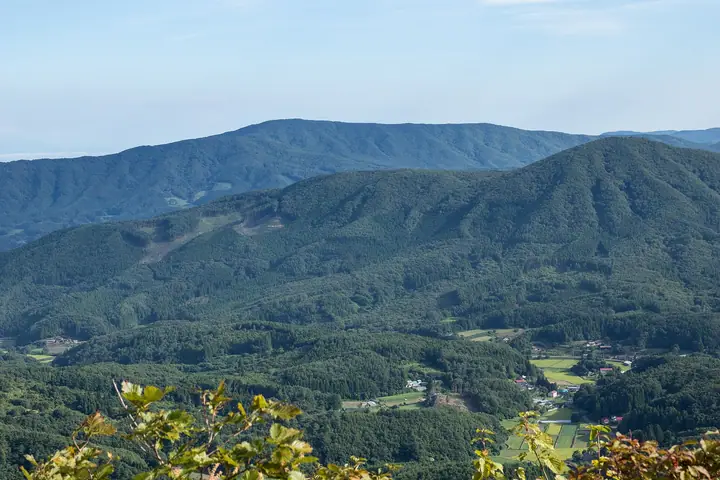
Mount Hiyama, also called Tennōzan, is a 1,057 m peak straddling Nihonmatsu City and Katsurao Village (Tamura District) in Fukushima Prefecture. It is the second-highest peak of the Abukuma Highlands and forms the core of Hiyama Prefectural Natural Park. Six trailheads — including Tazawa and Mobara on the Nihonmatsu side — reach the summit in 50–90 minutes. The summit hosts three Hiyama Shrines, each oriented toward a downhill village, and an annual three-lion dance is dedicated there in October. A joint mountain-opening festival hosted by five surrounding municipalities is held in early June. The mountain is listed in Utsukushima Hyakumeizan, Japan's 1,000 Mountains and the Michinoku 120, among other regional guides.
Mt. Hiyama at a glance
- Weather: The most settled day in the next 7 days is Wed, November 4: clear, gusts up to 6 m/s. Fri, Nov 6, Sat, Nov 7: strong wind (gusts up to 17 m/s).
Mt. Hiyama weather (hourly, 14 days)
Sunrise today 06:03, sunset 16:38
| Tue, 11/3 | Wed, 11/4 | Thu, 11/5 | Fri, 11/6 | Sat, 11/7 | Sun, 11/8 | Mon, 11/9 | Tue, 11/10 | Wed, 11/11 | Thu, 11/12 | Fri, 11/13 | Sat, 11/14 | Sun, 11/15 | Mon, 11/16 | Tue, 11/17 | |||||||||||||||||||||||||||||||||||||||||||||||||||||||||||||||||||||||
|---|---|---|---|---|---|---|---|---|---|---|---|---|---|---|---|---|---|---|---|---|---|---|---|---|---|---|---|---|---|---|---|---|---|---|---|---|---|---|---|---|---|---|---|---|---|---|---|---|---|---|---|---|---|---|---|---|---|---|---|---|---|---|---|---|---|---|---|---|---|---|---|---|---|---|---|---|---|---|---|---|---|---|---|---|---|
| Japan time | 15 | 17 | 19 | 21 | 23 | 1 | 3 | 5 | 7 | 9 | 11 | 13 | 15 | 18 | 21 | 0 | 3 | 6 | 9 | 12 | 15 | 18 | 21 | 0 | 3 | 6 | 9 | 12 | 15 | 18 | 21 | 0 | 3 | 6 | 9 | 12 | 15 | 18 | 21 | 0 | 3 | 6 | 9 | 12 | 15 | 18 | 21 | 0 | 3 | 6 | 9 | 15 | 21 | 3 | 9 | 15 | 21 | 3 | 9 | 15 | 21 | 3 | 9 | 15 | 21 | 3 | 9 | 15 | 21 | 3 | 9 | 15 | 21 | 3 | 9 | 15 | 21 | 3 | 9 | 15 | 21 | 3 | 9 | 15 | |
  |  | | | | | |   |   |  | | | | |   |   | | |   | | | |   | | | |   | | | | | | | |   | | |  | | | | | | | | | | | |   | | | | | | | | | | |   | | | | | | | | |  | | | | | | | | | | | | | | | ||
| Temperature | °C | 8° | 4° | 2° | 1° | 0° | 0° | 0° | 0° | 2° | 7° | 9° | 11° | 10° | 5° | 5° | 5° | 6° | 7° | 8° | 8° | 9° | 8° | 8° | 8° | 7° | 6° | 11° | 13° | 12° | 9° | 8° | 5° | 5° | 3° | 4° | 4° | 5° | 2° | 1° | 1° | 1° | -1° | 3° | 6° | 5° | 2° | 0° | 0° | 1° | 0° | 1° | 5° | 0° | 0° | 3° | 3° | 0° | 0° | 2° | 6° | 1° | -1° | 3° | 6° | 0° | 2° | 4° | 3° | -1° | -3° | 2° | 7° | 1° | 0° | 6° | 10° | 6° | 7° | 10° | 7° | 1° | -2° | 1° | 4° |
| Precipitation | mm | 0.1 | 2.1 | 3.2 | 9 | 9 | 5 | 0.2 | 0.3 | 0.3 | 0.3 | 0.2 | 0.7 | 0.5 | 0.3 | 0.2 | 0.6 | 2.8 | 15 | 0.1 | 0.6 | 0.1 | |||||||||||||||||||||||||||||||||||||||||||||||||||||||||||||||
| New snow | cm | ||||||||||||||||||||||||||||||||||||||||||||||||||||||||||||||||||||||||||||||||||||
| Snow depth | cm | 0 | 0 | 0 | 0 | 0 | 0 | 0 | 0 | 0 | 0 | 0 | 0 | 0 | 0 | 0 | 0 | 0 | 0 | 0 | 0 | 0 | 0 | 0 | 0 | 0 | 0 | 0 | 0 | 0 | 0 | 0 | 0 | 0 | 0 | 0 | 0 | 0 | 0 | 0 | 0 | 0 | 0 | 0 | 0 | 0 | 0 | 0 | 0 | 0 | 0 | 0 | 0 | 0 | 0 | 0 | 0 | 0 | 0 | 0 | 0 | 0 | 0 | 0 | 0 | 0 | 0 | 0 | 0 | 0 | 0 | 0 | 0 | 0 | 0 | 0 | 0 | 0 | 0 | 0 | 0 | 0 | 0 | 0 | 0 |
| Wind | m/s | 3 | 2 | 1 | 0 | 1 | 1 | 1 | 1 | 1 | 1 | 1 | 1 | 2 | 3 | 2 | 2 | 1 | 2 | 3 | 3 | 3 | 0 | 1 | 2 | 2 | 3 | 6 | 7 | 7 | 6 | 6 | 4 | 4 | 4 | 5 | 8 | 7 | 7 | 7 | 7 | 5 | 4 | 6 | 5 | 5 | 2 | 1 | 0 | 1 | 3 | 1 | 2 | 1 | 1 | 2 | 3 | 2 | 5 | 4 | 8 | 4 | 1 | 1 | 3 | 2 | 4 | 5 | 6 | 5 | 1 | 2 | 1 | 4 | 3 | 3 | 4 | 1 | 1 | 3 | 4 | 6 | 5 | 2 | 2 |
| Wind gusts | m/s | 8 | 8 | 3 | 3 | 2 | 2 | 2 | 2 | 2 | 4 | 5 | 5 | 6 | 8 | 7 | 5 | 5 | 4 | 7 | 8 | 9 | 7 | 2 | 5 | 5 | 6 | 12 | 16 | 16 | 15 | 13 | 12 | 9 | 11 | 12 | 17 | 17 | 15 | 15 | 14 | 14 | 11 | 14 | 14 | 13 | 11 | 4 | 3 | 3 | 6 | 6 | 5 | 5 | 3 | 5 | 9 | 8 | 10 | 14 | 17 | 17 | 9 | 5 | 10 | 7 | 8 | 11 | 15 | 13 | 10 | 6 | 6 | 8 | 8 | 7 | 8 | 8 | 8 | 8 | 11 | 15 | 14 | 9 | 6 |
| Wind dir. | ↓ | ↓ | ↓ | ↓ | ↓ | ↓ | ↓ | ↓ | ↓ | ↓ | ↓ | ↓ | ↓ | ↓ | ↓ | ↓ | ↓ | ↓ | ↓ | ↓ | ↓ | ↓ | ↓ | ↓ | ↓ | ↓ | ↓ | ↓ | ↓ | ↓ | ↓ | ↓ | ↓ | ↓ | ↓ | ↓ | ↓ | ↓ | ↓ | ↓ | ↓ | ↓ | ↓ | ↓ | ↓ | ↓ | ↓ | ↓ | ↓ | ↓ | ↓ | ↓ | ↓ | ↓ | ↓ | ↓ | ↓ | ↓ | ↓ | ↓ | ↓ | ↓ | ↓ | ↓ | ↓ | ↓ | ↓ | ↓ | ↓ | ↓ | ↓ | ↓ | ↓ | ↓ | ↓ | ↓ | ↓ | ↓ | ↓ | ↓ | ↓ | ↓ | ↓ | ↓ | |
Huts, campsites and lodging near Mt. Hiyama
Campsites
- 日山キャンプ場
Lists that include Mt. Hiyama
Utsukushima 100 Famous Mountains (Fukushima Prefecture) · Elevations of 1003 Mountains of Japan · 1000 Mountains of Japan
Mt. Hiyama facts
- Also known as
- 天王山
- Elevation
- 1,057 m
- Location
- Katsurao, Fukushima / Nihonmatsu, Fukushima
37.542731, 140.684191 - Website
- www.city.nihonmatsu.lg.jp
- Trail Map
- evergreen-net.jp
- Wikipedia
- ja.wikipedia.org