
Mt. Katasoneyama
片曽根山
Tamura, Fukushima · Elevation 718 m
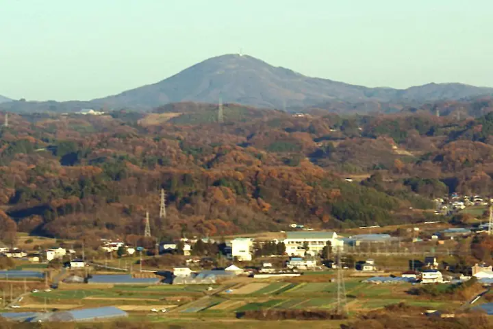
Mt. Katasoneyama is a 718 m peak in Tamura City, Fukushima Prefecture, called "Tamura Fuji" for its shapely conical form. Its name is said to derive from a legend in which Sakanoue no Tamuramaro's whistling arrow, loosed from Mt. Kurakake, grazed one of its ridges. Azaleas color the summit in late May around the mountain-opening ceremony, and from the top one can see the Azuma and Nasu ranges; a path linking 33 Kannon statues winds near the summit. It is listed among the Fukushima 100 Mountains and the 100 Fuji of Japan, among others.
Mt. Katasoneyama at a glance
- Weather: The most settled day in the next 7 days is Wed, November 4: clear, gusts up to 5 m/s. Sat, Nov 7, Sun, Nov 8: strong wind (gusts up to 16 m/s).
Mt. Katasoneyama weather (hourly, 14 days)
Sunrise today 06:04, sunset 16:39
| Tue, 11/3 | Wed, 11/4 | Thu, 11/5 | Fri, 11/6 | Sat, 11/7 | Sun, 11/8 | Mon, 11/9 | Tue, 11/10 | Wed, 11/11 | Thu, 11/12 | Fri, 11/13 | Sat, 11/14 | Sun, 11/15 | Mon, 11/16 | Tue, 11/17 | |||||||||||||||||||||||||||||||||||||||||||||||||||||||||||||||||||||||
|---|---|---|---|---|---|---|---|---|---|---|---|---|---|---|---|---|---|---|---|---|---|---|---|---|---|---|---|---|---|---|---|---|---|---|---|---|---|---|---|---|---|---|---|---|---|---|---|---|---|---|---|---|---|---|---|---|---|---|---|---|---|---|---|---|---|---|---|---|---|---|---|---|---|---|---|---|---|---|---|---|---|---|---|---|---|
| Japan time | 15 | 17 | 19 | 21 | 23 | 1 | 3 | 5 | 7 | 9 | 11 | 13 | 15 | 18 | 21 | 0 | 3 | 6 | 9 | 12 | 15 | 18 | 21 | 0 | 3 | 6 | 9 | 12 | 15 | 18 | 21 | 0 | 3 | 6 | 9 | 12 | 15 | 18 | 21 | 0 | 3 | 6 | 9 | 12 | 15 | 18 | 21 | 0 | 3 | 6 | 9 | 15 | 21 | 3 | 9 | 15 | 21 | 3 | 9 | 15 | 21 | 3 | 9 | 15 | 21 | 3 | 9 | 15 | 21 | 3 | 9 | 15 | 21 | 3 | 9 | 15 | 21 | 3 | 9 | 15 | 21 | 3 | 9 | 15 | |
 |  | | | | | |   |   | | | | |   | |   | | |   | | | |   | | | |   | | | | | | | |   | |   | | | |   | | |   | | | | | | | | | | | | | | | | | | | | |  | | | | | | | | | | | | | | | | | | | | ||
| Temperature | °C | 11° | 7° | 5° | 3° | 3° | 2° | 2° | 2° | 3° | 9° | 12° | 13° | 13° | 8° | 8° | 7° | 7° | 8° | 10° | 10° | 11° | 10° | 9° | 9° | 8° | 8° | 13° | 15° | 14° | 11° | 9° | 8° | 6° | 5° | 5° | 6° | 6° | 4° | 3° | 3° | 3° | 3° | 6° | 8° | 7° | 5° | 3° | 3° | 3° | 3° | 4° | 8° | 2° | 2° | 6° | 6° | 2° | 2° | 4° | 9° | 2° | 0° | 6° | 8° | 3° | 3° | 7° | 7° | 0° | -2° | 4° | 9° | 2° | 2° | 7° | 12° | 8° | 8° | 12° | 10° | 4° | 1° | 3° | 7° |
| Precipitation | mm | 2.5 | 4.5 | 9 | 9 | 4.1 | 0.2 | 0.3 | 0.2 | 0.3 | 0.3 | 0.2 | 0.4 | 0.4 | 0.2 | 0.4 | 0.5 | 2.7 | 13 | 0.1 | 1.1 | ||||||||||||||||||||||||||||||||||||||||||||||||||||||||||||||||
| New snow | cm | ||||||||||||||||||||||||||||||||||||||||||||||||||||||||||||||||||||||||||||||||||||
| Snow depth | cm | 0 | 0 | 0 | 0 | 0 | 0 | 0 | 0 | 0 | 0 | 0 | 0 | 0 | 0 | 0 | 0 | 0 | 0 | 0 | 0 | 0 | 0 | 0 | 0 | 0 | 0 | 0 | 0 | 0 | 0 | 0 | 0 | 0 | 0 | 0 | 0 | 0 | 0 | 0 | 0 | 0 | 0 | 0 | 0 | 0 | 0 | 0 | 0 | 0 | 0 | 0 | 0 | 0 | 0 | 0 | 0 | 0 | 0 | 0 | 0 | 0 | 0 | 0 | 0 | 0 | 0 | 0 | 0 | 0 | 0 | 0 | 0 | 0 | 0 | 0 | 0 | 0 | 0 | 0 | 0 | 0 | 0 | 0 | 0 |
| Wind | m/s | 5 | 2 | 1 | 1 | 0 | 1 | 1 | 1 | 1 | 1 | 0 | 1 | 0 | 3 | 1 | 1 | 1 | 2 | 4 | 4 | 3 | 0 | 1 | 2 | 2 | 3 | 4 | 6 | 6 | 5 | 6 | 4 | 4 | 5 | 6 | 8 | 7 | 7 | 7 | 7 | 7 | 6 | 6 | 7 | 6 | 4 | 3 | 2 | 0 | 1 | 2 | 1 | 2 | 1 | 2 | 4 | 2 | 4 | 4 | 6 | 2 | 0 | 2 | 5 | 3 | 3 | 2 | 4 | 2 | 1 | 0 | 2 | 4 | 3 | 3 | 4 | 1 | 1 | 3 | 4 | 2 | 1 | 0 | 2 |
| Wind gusts | m/s | 11 | 10 | 3 | 3 | 2 | 1 | 1 | 2 | 3 | 4 | 4 | 4 | 5 | 6 | 5 | 2 | 2 | 4 | 7 | 8 | 10 | 7 | 2 | 4 | 4 | 5 | 9 | 13 | 14 | 12 | 12 | 12 | 8 | 9 | 12 | 16 | 16 | 15 | 13 | 14 | 13 | 13 | 13 | 16 | 15 | 11 | 8 | 6 | 3 | 3 | 4 | 4 | 5 | 3 | 5 | 9 | 7 | 7 | 10 | 13 | 11 | 5 | 6 | 11 | 10 | 6 | 8 | 10 | 8 | 4 | 4 | 5 | 7 | 7 | 6 | 8 | 7 | 7 | 6 | 13 | 9 | 6 | 4 | 4 |
| Wind dir. | ↓ | ↓ | ↓ | ↓ | ↓ | ↓ | ↓ | ↓ | ↓ | ↓ | ↓ | ↓ | ↓ | ↓ | ↓ | ↓ | ↓ | ↓ | ↓ | ↓ | ↓ | ↓ | ↓ | ↓ | ↓ | ↓ | ↓ | ↓ | ↓ | ↓ | ↓ | ↓ | ↓ | ↓ | ↓ | ↓ | ↓ | ↓ | ↓ | ↓ | ↓ | ↓ | ↓ | ↓ | ↓ | ↓ | ↓ | ↓ | ↓ | ↓ | ↓ | ↓ | ↓ | ↓ | ↓ | ↓ | ↓ | ↓ | ↓ | ↓ | ↓ | ↓ | ↓ | ↓ | ↓ | ↓ | ↓ | ↓ | ↓ | ↓ | ↓ | ↓ | ↓ | ↓ | ↓ | ↓ | ↓ | ↓ | ↓ | ↓ | ↓ | ↓ | ↓ | ↓ | |
Huts, campsites and lodging near Mt. Katasoneyama
Lodging
- 桃源舎
Lists that include Mt. Katasoneyama
100 Fujis of Japan · Utsukushima 100 Famous Mountains (Fukushima Prefecture)
Mt. Katasoneyama facts
- Also known as
- 田村富士
- Elevation
- 718 m
- Location
- Tamura, Fukushima
37.426548, 140.568411 - Website
- www.tif.ne.jp
- Trail Map
- www.city.tamura.lg.jp (PDF)
- Wikipedia
- ja.wikipedia.org