
Mount Hiko
英彦山
Soeda, Fukuoka · Elevation 1,199 m
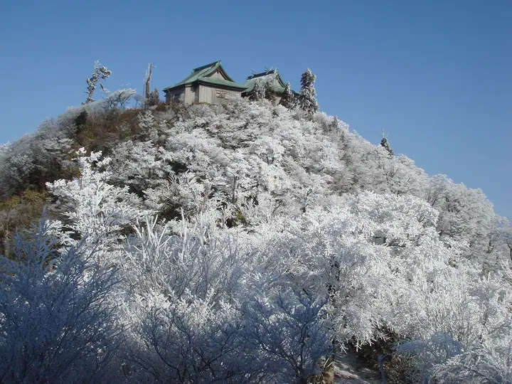
Mount Hiko is a 1,199-metre sacred peak straddling Soeda Town in Fukuoka and Nakatsu City in Ōita, made up of the North, Central and South summits. Long revered as one of the three great Shugendō centers of Japan together with Haguro-san and Ōmine-san, it enshrines the Upper Shrine of Hikosan-jingū at its summit. The mountain lies within Yaba-Hita-Hikosan Quasi-National Park and is listed among Japan's Nihon Nihyaku-meizan and Shin Nihon Hyakumeizan.
Mount Hiko at a glance
- Weather: The most settled day in the next 7 days is Sun, November 8: clear, gusts up to 7 m/s.
- Route: The shortest is Hikosan Kitadake from Buzenbō and Takasumi Shrine: about 1 h 43 min, 2.1 km, about 390 m of climbing.
Mount Hiko weather (hourly, 14 days)
Sunrise today 06:36, sunset 17:24
| Tue, 11/3 | Wed, 11/4 | Thu, 11/5 | Fri, 11/6 | Sat, 11/7 | Sun, 11/8 | Mon, 11/9 | Tue, 11/10 | Wed, 11/11 | Thu, 11/12 | Fri, 11/13 | Sat, 11/14 | Sun, 11/15 | Mon, 11/16 | Tue, 11/17 | |||||||||||||||||||||||||||||||||||||||||||||||||||||||||||||||||||||||
|---|---|---|---|---|---|---|---|---|---|---|---|---|---|---|---|---|---|---|---|---|---|---|---|---|---|---|---|---|---|---|---|---|---|---|---|---|---|---|---|---|---|---|---|---|---|---|---|---|---|---|---|---|---|---|---|---|---|---|---|---|---|---|---|---|---|---|---|---|---|---|---|---|---|---|---|---|---|---|---|---|---|---|---|---|---|
| Japan time | 15 | 17 | 19 | 21 | 23 | 1 | 3 | 5 | 7 | 9 | 11 | 13 | 15 | 18 | 21 | 0 | 3 | 6 | 9 | 12 | 15 | 18 | 21 | 0 | 3 | 6 | 9 | 12 | 15 | 18 | 21 | 0 | 3 | 6 | 9 | 12 | 15 | 18 | 21 | 0 | 3 | 6 | 9 | 12 | 15 | 18 | 21 | 0 | 3 | 6 | 9 | 15 | 21 | 3 | 9 | 15 | 21 | 3 | 9 | 15 | 21 | 3 | 9 | 15 | 21 | 3 | 9 | 15 | 21 | 3 | 9 | 15 | 21 | 3 | 9 | 15 | 21 | 3 | 9 | 15 | 21 | 3 | 9 | 15 | |
  | |   | |   | | | |   |   | | | |   | | | | | |   |   |   | | | | | | |  |  | | | | | | | | | | | | | | | | | | | | | | | | | | | | | | |   |  | | | | | | | | | | | |   | | | | | | | | | | | ||
| Temperature | °C | 11° | 10° | 8° | 6° | 5° | 6° | 6° | 6° | 7° | 9° | 12° | 14° | 13° | 10° | 9° | 9° | 9° | 9° | 12° | 14° | 15° | 13° | 13° | 11° | 10° | 7° | 10° | 12° | 10° | 5° | 4° | 3° | 2° | 1° | 4° | 7° | 7° | 2° | 0° | 1° | 1° | 1° | 6° | 9° | 9° | 6° | 5° | 7° | 5° | 5° | 8° | 10° | 3° | 3° | 7° | 8° | 4° | 3° | 5° | 7° | 1° | 1° | 6° | 9° | 2° | 2° | 8° | 10° | 3° | 3° | 7° | 13° | 7° | 8° | 11° | 12° | 11° | 10° | 10° | 12° | 6° | 4° | 7° | 10° |
| Precipitation | mm | 0.2 | 0.5 | 1.1 | 2.5 | 0.3 | 1.9 | 0.5 | 0.4 | 0.4 | 0.1 | 0.4 | 0.3 | 0.1 | 0.8 | 7 | 9 | 0.8 | 0.8 | 0.8 | 0.2 | 0.2 | |||||||||||||||||||||||||||||||||||||||||||||||||||||||||||||||
| New snow | cm | ||||||||||||||||||||||||||||||||||||||||||||||||||||||||||||||||||||||||||||||||||||
| Snow depth | cm | 0 | 0 | 0 | 0 | 0 | 0 | 0 | 0 | 0 | 0 | 0 | 0 | 0 | 0 | 0 | 0 | 0 | 0 | 0 | 0 | 0 | 0 | 0 | 0 | 0 | 0 | 0 | 0 | 0 | 0 | 0 | 0 | 0 | 0 | 0 | 0 | 0 | 0 | 0 | 0 | 0 | 0 | 0 | 0 | 0 | 0 | 0 | 0 | 0 | 0 | 0 | 0 | 0 | 0 | 0 | 0 | 0 | 0 | 0 | 0 | 0 | 0 | 0 | 0 | 0 | 0 | 0 | 0 | 0 | 0 | 0 | 0 | 0 | 0 | 0 | 0 | 0 | 0 | 0 | 0 | 0 | 0 | 0 | 0 |
| Wind | m/s | 3 | 2 | 2 | 2 | 2 | 2 | 2 | 2 | 3 | 3 | 4 | 3 | 3 | 3 | 2 | 1 | 1 | 1 | 2 | 2 | 4 | 3 | 4 | 3 | 3 | 3 | 4 | 5 | 5 | 3 | 4 | 4 | 4 | 4 | 4 | 3 | 3 | 1 | 1 | 1 | 1 | 2 | 2 | 2 | 2 | 1 | 2 | 1 | 1 | 1 | 2 | 3 | 1 | 1 | 3 | 5 | 2 | 3 | 4 | 3 | 0 | 0 | 0 | 2 | 1 | 1 | 2 | 3 | 2 | 3 | 2 | 2 | 1 | 2 | 3 | 2 | 1 | 2 | 3 | 4 | 2 | 2 | 3 | 2 |
| Wind gusts | m/s | 8 | 7 | 6 | 6 | 6 | 6 | 6 | 6 | 8 | 9 | 11 | 11 | 9 | 9 | 8 | 6 | 4 | 3 | 6 | 7 | 13 | 12 | 11 | 10 | 9 | 9 | 10 | 14 | 14 | 13 | 10 | 11 | 10 | 10 | 11 | 11 | 10 | 8 | 4 | 3 | 4 | 5 | 6 | 7 | 6 | 6 | 4 | 4 | 2 | 4 | 7 | 9 | 9 | 3 | 8 | 12 | 12 | 9 | 11 | 11 | 9 | 2 | 3 | 7 | 7 | 5 | 6 | 10 | 8 | 7 | 7 | 6 | 5 | 5 | 10 | 10 | 9 | 6 | 8 | 11 | 11 | 6 | 8 | 8 |
| Wind dir. | ↓ | ↓ | ↓ | ↓ | ↓ | ↓ | ↓ | ↓ | ↓ | ↓ | ↓ | ↓ | ↓ | ↓ | ↓ | ↓ | ↓ | ↓ | ↓ | ↓ | ↓ | ↓ | ↓ | ↓ | ↓ | ↓ | ↓ | ↓ | ↓ | ↓ | ↓ | ↓ | ↓ | ↓ | ↓ | ↓ | ↓ | ↓ | ↓ | ↓ | ↓ | ↓ | ↓ | ↓ | ↓ | ↓ | ↓ | ↓ | ↓ | ↓ | ↓ | ↓ | ↓ | ↓ | ↓ | ↓ | ↓ | ↓ | ↓ | ↓ | ↓ | ↓ | ↓ | ↓ | ↓ | ↓ | ↓ | ↓ | ↓ | ↓ | ↓ | ↓ | ↓ | ↓ | ↓ | ↓ | ↓ | ↓ | ↓ | ↓ | ↓ | ↓ | ↓ | ↓ | |
Mount Hiko hiking routes
- Hikosan Kitadake from Buzenbō and Takasumi Shrine 2.1 km · Ascent 392 m parking
- Mount Hiko Naka-dake via the Omotesando Trail 6.3 km · Ascent 614 m 別所駐車場
Hiking times are estimates calculated from the terrain.
Lists that include Mount Hiko
Japan 200 Famous Mountains · Japan's 300 Famous Mountains · 100 Famous Mountains with First-order Triangulation Points · New Japan 100 Famous Mountains · 100 Low Mountains of Japan · Illustrated Collection of Japan's Famous Mountains · Japan's 3 Hiko Mountains · Kyushu 100 Famous Mountains · Oita 100 Mountains · Elevations of 1003 Mountains of Japan · 1000 Mountains of Japan
Mount Hiko facts
- Also known as
- 英彦山南岳
- Elevation
- 1,199 m
- Location
- Soeda, Fukuoka
33.476252, 130.925961 - National Park
- 耶馬日田英彦山国定公園
- Website
- www.town.soeda.fukuoka.jp
- Trail Map
- www.town.soeda.fukuoka.jp
- Access Information
- hikosanjingu.or.jp
- Wikipedia
- ja.wikipedia.org