
Mount Higashi-Otafuku
東おたふく山
Kobe, Hyogo · Elevation 697 m
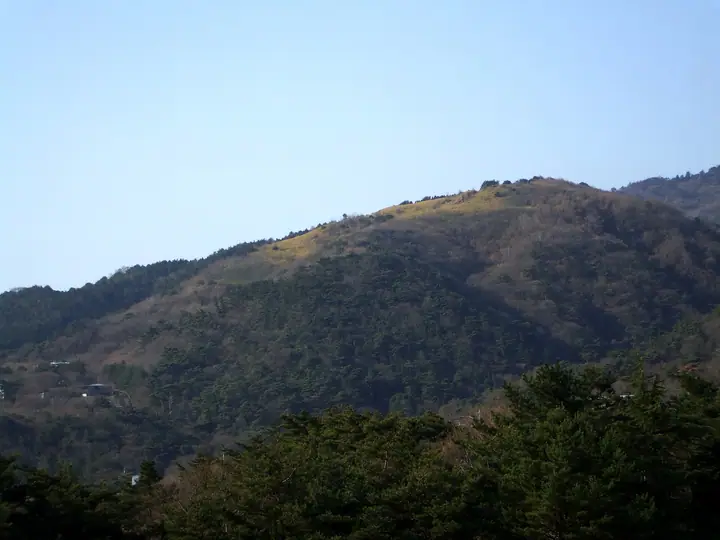
Mount Higashi-Otafuku is a 697 m peak on the border between Kobe's Higashinada Ward and Ashiya City, set in the eastern Rokko range and falling within the Rokko sector of Setonaikai National Park. Its gentle summit ridge holds the only grass meadow in Rokko, where pampas grass (susuki) spreads in autumn — a relic of pre-war thatch fields exceeding 80 hectares that are now tended by a conservation group. The summit is roughly 50 minutes from the Higashi-Otafuku-yama trailhead bus stop, with longer approaches via the Ashiya River and the famed Rock Garden route.
Mount Higashi-Otafuku at a glance
- Weather: The most settled day in the next 7 days is Mon, November 9: clear, gusts up to 6 m/s.
- Route: The shortest is Rokko, from the Ashiya Rock Garden over Kazefukiiwa and Higashi-Otafukuyama to Okuike: about 4 h 17 min, 8.1 km, about 780 m of climbing.
Mount Higashi-Otafuku weather (hourly, 14 days)
Sunrise today 06:21, sunset 17:04
| Tue, 11/3 | Wed, 11/4 | Thu, 11/5 | Fri, 11/6 | Sat, 11/7 | Sun, 11/8 | Mon, 11/9 | Tue, 11/10 | Wed, 11/11 | Thu, 11/12 | Fri, 11/13 | Sat, 11/14 | Sun, 11/15 | Mon, 11/16 | Tue, 11/17 | |||||||||||||||||||||||||||||||||||||||||||||||||||||||||||||||||||||||
|---|---|---|---|---|---|---|---|---|---|---|---|---|---|---|---|---|---|---|---|---|---|---|---|---|---|---|---|---|---|---|---|---|---|---|---|---|---|---|---|---|---|---|---|---|---|---|---|---|---|---|---|---|---|---|---|---|---|---|---|---|---|---|---|---|---|---|---|---|---|---|---|---|---|---|---|---|---|---|---|---|---|---|---|---|---|
| Japan time | 15 | 17 | 19 | 21 | 23 | 1 | 3 | 5 | 7 | 9 | 11 | 13 | 15 | 18 | 21 | 0 | 3 | 6 | 9 | 12 | 15 | 18 | 21 | 0 | 3 | 6 | 9 | 12 | 15 | 18 | 21 | 0 | 3 | 6 | 9 | 12 | 15 | 18 | 21 | 0 | 3 | 6 | 9 | 12 | 15 | 18 | 21 | 0 | 3 | 6 | 9 | 15 | 21 | 3 | 9 | 15 | 21 | 3 | 9 | 15 | 21 | 3 | 9 | 15 | 21 | 3 | 9 | 15 | 21 | 3 | 9 | 15 | 21 | 3 | 9 | 15 | 21 | 3 | 9 | 15 | 21 | 3 | 9 | 15 | |
  |   |   | | | |  | | | | | | |   |   |   |   | |   | |  |  |   | | | | | | | | | | | | |   | | | | | | | | | | | | | | | |   | |   | | | | | | | |  | | | | | | | | | | | | | | | | | | | |  | | | ||
| Temperature | °C | 15° | 13° | 11° | 11° | 10° | 10° | 9° | 9° | 9° | 12° | 15° | 17° | 16° | 14° | 13° | 12° | 12° | 12° | 13° | 17° | 19° | 15° | 15° | 16° | 14° | 12° | 15° | 17° | 17° | 13° | 10° | 8° | 6° | 6° | 9° | 12° | 11° | 8° | 6° | 6° | 5° | 5° | 10° | 13° | 12° | 10° | 9° | 9° | 8° | 9° | 11° | 13° | 8° | 7° | 10° | 13° | 8° | 6° | 8° | 10° | 5° | 4° | 9° | 12° | 7° | 7° | 10° | 11° | 5° | 4° | 8° | 14° | 8° | 8° | 12° | 14° | 12° | 12° | 14° | 14° | 8° | 5° | 8° | 11° |
| Precipitation | mm | 3.2 | 6 | 1.6 | 1.5 | 0.3 | 1.3 | 0.7 | 0.7 | 0.5 | 0.1 | 3.0 | 1.4 | 0.3 | |||||||||||||||||||||||||||||||||||||||||||||||||||||||||||||||||||||||
| New snow | cm | ||||||||||||||||||||||||||||||||||||||||||||||||||||||||||||||||||||||||||||||||||||
| Snow depth | cm | 0 | 0 | 0 | 0 | 0 | 0 | 0 | 0 | 0 | 0 | 0 | 0 | 0 | 0 | 0 | 0 | 0 | 0 | 0 | 0 | 0 | 0 | 0 | 0 | 0 | 0 | 0 | 0 | 0 | 0 | 0 | 0 | 0 | 0 | 0 | 0 | 0 | 0 | 0 | 0 | 0 | 0 | 0 | 0 | 0 | 0 | 0 | 0 | 0 | 0 | 0 | 0 | 0 | 0 | 0 | 0 | 0 | 0 | 0 | 0 | 0 | 0 | 0 | 0 | 0 | 0 | 0 | 0 | 0 | 0 | 0 | 0 | 0 | 0 | 0 | 0 | 0 | 0 | 0 | 0 | 0 | 0 | 0 | 0 |
| Wind | m/s | 4 | 3 | 3 | 3 | 2 | 2 | 3 | 2 | 3 | 3 | 3 | 3 | 3 | 4 | 4 | 4 | 4 | 2 | 3 | 1 | 1 | 1 | 1 | 3 | 3 | 1 | 3 | 4 | 5 | 3 | 3 | 3 | 2 | 2 | 3 | 5 | 5 | 3 | 1 | 1 | 2 | 1 | 1 | 4 | 3 | 2 | 1 | 1 | 1 | 1 | 1 | 2 | 1 | 1 | 1 | 3 | 3 | 4 | 3 | 6 | 2 | 2 | 1 | 1 | 1 | 3 | 5 | 5 | 2 | 1 | 1 | 1 | 1 | 1 | 2 | 2 | 1 | 1 | 3 | 6 | 6 | 2 | 3 | 3 |
| Wind gusts | m/s | 9 | 10 | 8 | 8 | 8 | 7 | 8 | 8 | 8 | 9 | 8 | 8 | 8 | 9 | 10 | 10 | 9 | 8 | 6 | 6 | 4 | 3 | 4 | 10 | 13 | 9 | 8 | 11 | 13 | 12 | 10 | 10 | 10 | 8 | 9 | 14 | 14 | 14 | 9 | 6 | 6 | 6 | 6 | 10 | 11 | 9 | 6 | 4 | 4 | 4 | 4 | 6 | 7 | 4 | 6 | 13 | 10 | 13 | 12 | 17 | 16 | 7 | 5 | 6 | 5 | 8 | 14 | 16 | 13 | 8 | 6 | 5 | 6 | 4 | 6 | 7 | 8 | 8 | 9 | 16 | 17 | 15 | 9 | 11 |
| Wind dir. | ↓ | ↓ | ↓ | ↓ | ↓ | ↓ | ↓ | ↓ | ↓ | ↓ | ↓ | ↓ | ↓ | ↓ | ↓ | ↓ | ↓ | ↓ | ↓ | ↓ | ↓ | ↓ | ↓ | ↓ | ↓ | ↓ | ↓ | ↓ | ↓ | ↓ | ↓ | ↓ | ↓ | ↓ | ↓ | ↓ | ↓ | ↓ | ↓ | ↓ | ↓ | ↓ | ↓ | ↓ | ↓ | ↓ | ↓ | ↓ | ↓ | ↓ | ↓ | ↓ | ↓ | ↓ | ↓ | ↓ | ↓ | ↓ | ↓ | ↓ | ↓ | ↓ | ↓ | ↓ | ↓ | ↓ | ↓ | ↓ | ↓ | ↓ | ↓ | ↓ | ↓ | ↓ | ↓ | ↓ | ↓ | ↓ | ↓ | ↓ | ↓ | ↓ | ↓ | ↓ | |
Mount Higashi-Otafuku hiking routes
Hiking times are estimates calculated from the terrain.
Huts, campsites and lodging near Mount Higashi-Otafuku
Campsites
- FBR (ForestBaseRokko)
Lodging
- Grand Hotel Rokko SkyVilla
- Diamond Society
- Maple Arima
- 旅館やまと
- Koro-kan
Mount Higashi-Otafuku facts
- Also known as
- 東お多福山
- Elevation
- 697 m
- Location
- Kobe, Hyogo
34.769079, 135.273097 - National Park
- 瀬戸内海国立公園
- Website
- kobe-rokko.jp
- Trail Map
- www.city.kobe.lg.jp (PDF)
- Access Information
- www.city.ashiya.lg.jp (PDF)
- Wikipedia
- ja.wikipedia.org