
Mount Hakodate
函館山
Hakodate, Hokkaido · Elevation 334 m
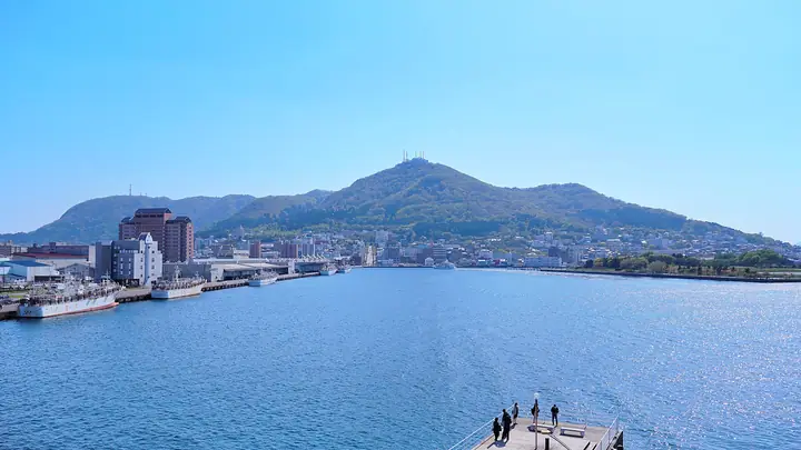
Mount Hakodate is a 334-meter volcanic peak and tombolo at the western edge of Hakodate City, Hokkaido, whose recumbent profile gives it the alternate name Gagyū-zan, "the reclining-ox mountain." Fortified in the Meiji era to defend Hakodate Harbor from Russia, it was so secret that period photographs and maps had its outline erased. Today some 600 plant species and 150 bird species inhabit its slopes, and eleven hiking trails and the Mount Hakodate Ropeway carry visitors to one of the world's most celebrated night-view summits. The peak is counted among Hokkaido's 100 famous mountains and Japan's 100 low mountains.
Mount Hakodate at a glance
- Weather: The most settled day in the next 7 days is Thu, November 5: cloudy, gusts up to 5 m/s. Sat, Nov 7, Sun, Nov 8: strong wind (gusts up to 21 m/s).
- Route: The shortest is Mount Hakodate and Mount Irie Return via the Old Trail: about 2 h 38 min, 6.6 km, about 310 m of climbing.
Mount Hakodate weather (hourly, 14 days)
Sunrise today 06:11, sunset 16:31
| Tue, 11/3 | Wed, 11/4 | Thu, 11/5 | Fri, 11/6 | Sat, 11/7 | Sun, 11/8 | Mon, 11/9 | Tue, 11/10 | Wed, 11/11 | Thu, 11/12 | Fri, 11/13 | Sat, 11/14 | Sun, 11/15 | Mon, 11/16 | Tue, 11/17 | |||||||||||||||||||||||||||||||||||||||||||||||||||||||||||||||||||||||
|---|---|---|---|---|---|---|---|---|---|---|---|---|---|---|---|---|---|---|---|---|---|---|---|---|---|---|---|---|---|---|---|---|---|---|---|---|---|---|---|---|---|---|---|---|---|---|---|---|---|---|---|---|---|---|---|---|---|---|---|---|---|---|---|---|---|---|---|---|---|---|---|---|---|---|---|---|---|---|---|---|---|---|---|---|---|
| Japan time | 15 | 17 | 19 | 21 | 23 | 1 | 3 | 5 | 7 | 9 | 11 | 13 | 15 | 18 | 21 | 0 | 3 | 6 | 9 | 12 | 15 | 18 | 21 | 0 | 3 | 6 | 9 | 12 | 15 | 18 | 21 | 0 | 3 | 6 | 9 | 12 | 15 | 18 | 21 | 0 | 3 | 6 | 9 | 12 | 15 | 18 | 21 | 0 | 3 | 6 | 9 | 15 | 21 | 3 | 9 | 15 | 21 | 3 | 9 | 15 | 21 | 3 | 9 | 15 | 21 | 3 | 9 | 15 | 21 | 3 | 9 | 15 | 21 | 3 | 9 | 15 | 21 | 3 | 9 | 15 | 21 | 3 | 9 | 15 | |
 |   |  | | |   |   | | | | | | |  | | | | |   |   |   | |   | | | |   | | | | | |   |   |   |   | | | | | |   |   | | |   |   | | | | | | | | | | |   | | | | | |   | |  | | | | | | | | | |   | | | | |  | | | | ||
| Temperature | °C | 6° | 5° | 4° | 5° | 5° | 5° | 6° | 6° | 5° | 7° | 8° | 8° | 8° | 5° | 3° | 4° | 4° | 5° | 10° | 11° | 11° | 10° | 10° | 11° | 11° | 10° | 11° | 12° | 10° | 7° | 4° | 2° | 2° | 1° | 1° | 2° | 1° | 1° | 1° | 1° | 1° | 1° | 2° | 3° | 2° | 2° | 2° | 2° | 2° | 1° | 2° | 2° | -1° | -1° | 1° | 3° | 2° | 1° | 2° | 5° | 2° | 1° | 4° | 4° | 1° | -1° | 2° | 2° | -1° | -1° | 2° | 6° | 2° | 4° | 8° | 10° | 9° | 7° | 5° | 4° | 0° | 0° | 2° | 5° |
| Precipitation | mm | 0.9 | 0.7 | 0.1 | 1.7 | 3.1 | 0.3 | 1.0 | 0.8 | 0.1 | 0.2 | 0.2 | 0.3 | 0.5 | 0.6 | 0.8 | 0.6 | 0.5 | 0.5 | 0.4 | 0.3 | 0.2 | 0.3 | 0.2 | 0.4 | 4.1 | 1.5 | 0.9 | 0.2 | 0.1 | 0.4 | 1.3 | 4.3 | 0.9 | 0.7 | ||||||||||||||||||||||||||||||||||||||||||||||||||
| New snow | cm | <.1 | 0.3 | 0.5 | 0.6 | 0.3 | 0.2 | 0.2 | 0.2 | 0.1 | 0.1 | 0.1 | <.1 | <.1 | 0.5 | <.1 | |||||||||||||||||||||||||||||||||||||||||||||||||||||||||||||||||||||
| Snow depth | cm | 0 | 0 | 0 | 0 | 0 | 0 | 0 | 0 | 0 | 0 | 0 | 0 | 0 | 0 | 0 | 0 | 0 | 0 | 0 | 0 | 0 | 0 | 0 | 0 | 0 | 0 | 0 | 0 | 0 | 0 | 0 | 0 | 0 | 0 | <1 | <1 | <1 | <1 | <1 | <1 | <1 | <1 | <1 | <1 | <1 | 0 | 0 | 0 | 0 | 0 | 0 | 0 | 0 | 0 | 0 | 0 | 0 | <1 | <1 | 0 | 0 | 0 | 0 | 0 | 0 | 0 | 0 | 0 | 0 | 0 | 0 | 0 | 0 | 0 | 0 | 0 | 0 | 0 | 0 | 0 | 0 | 0 | 0 | 0 |
| Wind | m/s | 7 | 4 | 3 | 2 | 3 | 7 | 8 | 6 | 4 | 5 | 5 | 4 | 3 | 2 | 2 | 1 | 2 | 2 | 2 | 2 | 3 | 3 | 4 | 3 | 1 | 1 | 1 | 3 | 8 | 9 | 10 | 9 | 8 | 9 | 9 | 10 | 11 | 9 | 9 | 10 | 10 | 10 | 12 | 12 | 10 | 7 | 5 | 4 | 5 | 3 | 6 | 6 | 3 | 3 | 1 | 4 | 6 | 7 | 4 | 3 | 4 | 2 | 3 | 5 | 3 | 3 | 5 | 5 | 4 | 2 | 1 | 1 | 2 | 1 | 2 | 5 | 2 | 1 | 6 | 6 | 6 | 3 | 1 | 5 |
| Wind gusts | m/s | 12 | 12 | 7 | 6 | 6 | 12 | 12 | 12 | 10 | 9 | 9 | 8 | 8 | 5 | 4 | 4 | 4 | 4 | 4 | 5 | 4 | 4 | 6 | 6 | 4 | 2 | 3 | 4 | 14 | 15 | 16 | 16 | 14 | 15 | 15 | 19 | 20 | 18 | 16 | 17 | 17 | 17 | 19 | 21 | 20 | 17 | 12 | 9 | 8 | 8 | 10 | 12 | 11 | 6 | 5 | 7 | 11 | 12 | 12 | 8 | 6 | 6 | 5 | 10 | 9 | 6 | 8 | 10 | 8 | 6 | 4 | 5 | 5 | 4 | 4 | 7 | 7 | 4 | 9 | 11 | 11 | 9 | 6 | 10 |
| Wind dir. | ↓ | ↓ | ↓ | ↓ | ↓ | ↓ | ↓ | ↓ | ↓ | ↓ | ↓ | ↓ | ↓ | ↓ | ↓ | ↓ | ↓ | ↓ | ↓ | ↓ | ↓ | ↓ | ↓ | ↓ | ↓ | ↓ | ↓ | ↓ | ↓ | ↓ | ↓ | ↓ | ↓ | ↓ | ↓ | ↓ | ↓ | ↓ | ↓ | ↓ | ↓ | ↓ | ↓ | ↓ | ↓ | ↓ | ↓ | ↓ | ↓ | ↓ | ↓ | ↓ | ↓ | ↓ | ↓ | ↓ | ↓ | ↓ | ↓ | ↓ | ↓ | ↓ | ↓ | ↓ | ↓ | ↓ | ↓ | ↓ | ↓ | ↓ | ↓ | ↓ | ↓ | ↓ | ↓ | ↓ | ↓ | ↓ | ↓ | ↓ | ↓ | ↓ | ↓ | ↓ | |
Mount Hakodate hiking routes
Hiking times are estimates calculated from the terrain.
Huts, campsites and lodging near Mount Hakodate
Lodging
- Pension Country Born
- Hotel Hakodateyama
- HOTEL白林
- Hotel Hachimansaka
- HakoBA Hakodate by THE SHARE HOTELS
Lists that include Mount Hakodate
100 Low Mountains of Japan · Hokkaido 100 Famous Mountains · Elevations of 1003 Mountains of Japan · 1000 Mountains of Japan
Mount Hakodate facts
- Also known as
- 臥牛山
- Elevation
- 334 m
- Location
- Hakodate, Hokkaido
41.759320, 140.703986 - Website
- www.city.hakodate.hokkaido.jp
- Trail Map
- www.city.hakodate.hokkaido.jp (PDF)
- Access Information
- hakodate-kankou.com
- Wikipedia
- ja.wikipedia.org