
Kankyozan
閑居山
Ishioka, Ibaraki / Kasumigaura, Ibaraki · Elevation 227 m
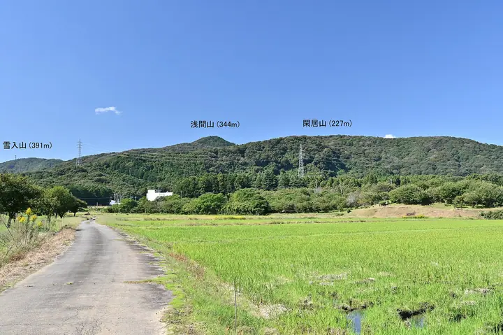
Kankyozan is a 227 m mountain on the border of Kasumigaura and Ishioka cities, Ibaraki Prefecture, in the southeastern Tsukuba range between Yukiiriyama and Gongenyama. Formerly called Shizukuyama and sung of in classical poetry, it owes its present name to a tradition that Kobō Daishi secluded himself in a cave here; Ganji-ji temple, linked to him, stands at its eastern foot. On its eastern flank a large granite boulder bears the 'Hundred-Body Rock Buddhas' (Hyakutai Magaibutsu), Kamakura-period carvings designated an Ibaraki cultural property, reachable from the Chiyoda Alps hiking trails.
Kankyozan at a glance
- Weather: The most settled day in the next 7 days is Sun, November 8: clear, gusts up to 5 m/s.
Kankyozan weather (hourly, 14 days)
Sunrise today 06:03, sunset 16:42
| Tue, 11/3 | Wed, 11/4 | Thu, 11/5 | Fri, 11/6 | Sat, 11/7 | Sun, 11/8 | Mon, 11/9 | Tue, 11/10 | Wed, 11/11 | Thu, 11/12 | Fri, 11/13 | Sat, 11/14 | Sun, 11/15 | Mon, 11/16 | Tue, 11/17 | |||||||||||||||||||||||||||||||||||||||||||||||||||||||||||||||||||||||
|---|---|---|---|---|---|---|---|---|---|---|---|---|---|---|---|---|---|---|---|---|---|---|---|---|---|---|---|---|---|---|---|---|---|---|---|---|---|---|---|---|---|---|---|---|---|---|---|---|---|---|---|---|---|---|---|---|---|---|---|---|---|---|---|---|---|---|---|---|---|---|---|---|---|---|---|---|---|---|---|---|---|---|---|---|---|
| Japan time | 15 | 17 | 19 | 21 | 23 | 1 | 3 | 5 | 7 | 9 | 11 | 13 | 15 | 18 | 21 | 0 | 3 | 6 | 9 | 12 | 15 | 18 | 21 | 0 | 3 | 6 | 9 | 12 | 15 | 18 | 21 | 0 | 3 | 6 | 9 | 12 | 15 | 18 | 21 | 0 | 3 | 6 | 9 | 12 | 15 | 18 | 21 | 0 | 3 | 6 | 9 | 15 | 21 | 3 | 9 | 15 | 21 | 3 | 9 | 15 | 21 | 3 | 9 | 15 | 21 | 3 | 9 | 15 | 21 | 3 | 9 | 15 | 21 | 3 | 9 | 15 | 21 | 3 | 9 | 15 | 21 | 3 | 9 | 15 | |
  |   |   | |   | | | |   |   | | | | |   | | | |   | | |   |   | | | |  | | |  | | | | | | | | | | | | | |   | | | | | | | | | | | |   | | | | |   |  | | | | | | | | | | | | | | | | | | | | | | | ||
| Temperature | °C | 17° | 14° | 13° | 13° | 12° | 12° | 11° | 12° | 11° | 12° | 14° | 14° | 14° | 13° | 12° | 11° | 11° | 13° | 13° | 16° | 16° | 14° | 12° | 12° | 13° | 12° | 16° | 20° | 20° | 16° | 14° | 13° | 13° | 9° | 13° | 16° | 15° | 10° | 7° | 9° | 9° | 7° | 10° | 13° | 14° | 10° | 10° | 9° | 9° | 9° | 9° | 11° | 10° | 9° | 10° | 10° | 7° | 4° | 11° | 13° | 9° | 5° | 10° | 13° | 10° | 7° | 12° | 12° | 7° | 4° | 8° | 11° | 7° | 7° | 11° | 16° | 13° | 13° | 14° | 20° | 10° | 7° | 8° | 10° |
| Precipitation | mm | 0.2 | 0.7 | 2.7 | 2.5 | 12 | 16 | 2.9 | 1.0 | 0.4 | 0.1 | 0.4 | 0.3 | 0.4 | 0.2 | 0.4 | 2.5 | 9 | 0.3 | ||||||||||||||||||||||||||||||||||||||||||||||||||||||||||||||||||
| New snow | cm | ||||||||||||||||||||||||||||||||||||||||||||||||||||||||||||||||||||||||||||||||||||
| Snow depth | cm | 0 | 0 | 0 | 0 | 0 | 0 | 0 | 0 | 0 | 0 | 0 | 0 | 0 | 0 | 0 | 0 | 0 | 0 | 0 | 0 | 0 | 0 | 0 | 0 | 0 | 0 | 0 | 0 | 0 | 0 | 0 | 0 | 0 | 0 | 0 | 0 | 0 | 0 | 0 | 0 | 0 | 0 | 0 | 0 | 0 | 0 | 0 | 0 | 0 | 0 | 0 | 0 | 0 | 0 | 0 | 0 | 0 | 0 | 0 | 0 | 0 | 0 | 0 | 0 | 0 | 0 | 0 | 0 | 0 | 0 | 0 | 0 | 0 | 0 | 0 | 0 | 0 | 0 | 0 | 0 | 0 | 0 | 0 | 0 |
| Wind | m/s | 2 | 3 | 3 | 3 | 3 | 3 | 3 | 3 | 3 | 3 | 4 | 3 | 3 | 2 | 1 | 3 | 4 | 5 | 7 | 2 | 1 | 1 | 1 | 1 | 1 | 1 | 2 | 2 | 2 | 2 | 3 | 2 | 2 | 1 | 1 | 5 | 4 | 1 | 1 | 1 | 2 | 1 | 1 | 1 | 1 | 3 | 2 | 2 | 3 | 3 | 4 | 4 | 4 | 4 | 4 | 5 | 2 | 2 | 3 | 4 | 3 | 0 | 1 | 1 | 1 | 1 | 1 | 5 | 3 | 2 | 2 | 2 | 1 | 1 | 0 | 3 | 3 | 2 | 1 | 4 | 2 | 3 | 2 | 3 |
| Wind gusts | m/s | 5 | 5 | 6 | 6 | 5 | 6 | 7 | 6 | 5 | 6 | 7 | 8 | 7 | 5 | 5 | 6 | 8 | 9 | 13 | 12 | 6 | 2 | 3 | 3 | 2 | 3 | 5 | 6 | 5 | 4 | 7 | 6 | 6 | 4 | 4 | 10 | 10 | 8 | 3 | 3 | 4 | 4 | 4 | 5 | 4 | 6 | 5 | 5 | 6 | 6 | 7 | 7 | 8 | 8 | 8 | 11 | 9 | 3 | 8 | 10 | 9 | 6 | 4 | 5 | 4 | 2 | 4 | 11 | 11 | 6 | 6 | 6 | 5 | 2 | 3 | 6 | 7 | 6 | 5 | 7 | 14 | 8 | 7 | 7 |
| Wind dir. | ↓ | ↓ | ↓ | ↓ | ↓ | ↓ | ↓ | ↓ | ↓ | ↓ | ↓ | ↓ | ↓ | ↓ | ↓ | ↓ | ↓ | ↓ | ↓ | ↓ | ↓ | ↓ | ↓ | ↓ | ↓ | ↓ | ↓ | ↓ | ↓ | ↓ | ↓ | ↓ | ↓ | ↓ | ↓ | ↓ | ↓ | ↓ | ↓ | ↓ | ↓ | ↓ | ↓ | ↓ | ↓ | ↓ | ↓ | ↓ | ↓ | ↓ | ↓ | ↓ | ↓ | ↓ | ↓ | ↓ | ↓ | ↓ | ↓ | ↓ | ↓ | ↓ | ↓ | ↓ | ↓ | ↓ | ↓ | ↓ | ↓ | ↓ | ↓ | ↓ | ↓ | ↓ | ↓ | ↓ | ↓ | ↓ | ↓ | ↓ | ↓ | ↓ | ↓ | ↓ | |
Huts, campsites and lodging near Kankyozan
Lodging
- いやしの里
- サークルロッジ
Kankyozan facts
- Also known as
- 志筑山
- Elevation
- 227 m
- Location
- Ishioka, Ibaraki / Kasumigaura, Ibaraki
36.185589, 140.206388 - Website
- www.city.kasumigaura.lg.jp
- Trail Map
- yukiiri.jp (PDF)
- Wikipedia
- ja.wikipedia.org