
Iyogatake South Peak
伊予ヶ岳(南峰)
Minamiboso, Chiba · Elevation 336 m
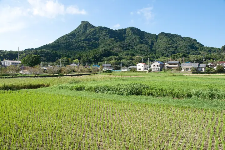
The South Peak is the high point, at 336 meters, of Iyogatake in Minamiboso, Chiba Prefecture. The only mountain in the prefecture whose name ends in "-take," its sharp rock summit—unusual for the Boso hills—has earned it the nickname "the Matterhorn of Boso." Ropes and chains aid the rocky stretch just below the top, the climb begins at Heguri Tenjin Shrine, and the summit offers a 360-degree panorama. It is listed among the 350 Mountains around Tokyo.
Iyogatake South Peak at a glance
- Weather: The most settled day in the next 7 days is Sat, November 7: clear, gusts up to 7 m/s. Thu, Nov 5: strong wind (gusts up to 17 m/s).
- Route: The shortest is Mount Iyogatake from Heguri Tenjin Shrine Circuit: about 2 h 11 min, 3.4 km, about 340 m of climbing.
Iyogatake South Peak weather (hourly, 14 days)
Sunrise today 06:03, sunset 16:45
| Tue, 11/3 | Wed, 11/4 | Thu, 11/5 | Fri, 11/6 | Sat, 11/7 | Sun, 11/8 | Mon, 11/9 | Tue, 11/10 | Wed, 11/11 | Thu, 11/12 | Fri, 11/13 | Sat, 11/14 | Sun, 11/15 | Mon, 11/16 | Tue, 11/17 | |||||||||||||||||||||||||||||||||||||||||||||||||||||||||||||||||||||||
|---|---|---|---|---|---|---|---|---|---|---|---|---|---|---|---|---|---|---|---|---|---|---|---|---|---|---|---|---|---|---|---|---|---|---|---|---|---|---|---|---|---|---|---|---|---|---|---|---|---|---|---|---|---|---|---|---|---|---|---|---|---|---|---|---|---|---|---|---|---|---|---|---|---|---|---|---|---|---|---|---|---|---|---|---|---|
| Japan time | 21 | 23 | 1 | 3 | 5 | 7 | 9 | 11 | 13 | 15 | 17 | 19 | 21 | 0 | 3 | 6 | 9 | 12 | 15 | 18 | 21 | 0 | 3 | 6 | 9 | 12 | 15 | 18 | 21 | 0 | 3 | 6 | 9 | 12 | 15 | 18 | 21 | 0 | 3 | 6 | 9 | 12 | 15 | 18 | 21 | 0 | 3 | 6 | 9 | 12 | 15 | 21 | 3 | 9 | 15 | 21 | 3 | 9 | 15 | 21 | 3 | 9 | 15 | 21 | 3 | 9 | 15 | 21 | 3 | 9 | 15 | 21 | 3 | 9 | 15 | 21 | 3 | 9 | 15 | 21 | 3 | 9 | 15 | 21 | |
  | | |   | |   | | | | | | | | | | | |   | |   |   |   | | |   |  | |  | | |   | | | | | | | | | | | | | | | | | | | | | | |   |   | | | | |   |  | | | | | | | | | |   | | | | | | | | | | | | | | ||
| Temperature | °C | 14° | 14° | 14° | 13° | 13° | 12° | 12° | 13° | 13° | 13° | 11° | 11° | 12° | 12° | 12° | 12° | 13° | 16° | 17° | 15° | 14° | 13° | 13° | 17° | 17° | 21° | 20° | 15° | 15° | 14° | 13° | 12° | 14° | 17° | 16° | 13° | 10° | 10° | 9° | 9° | 11° | 13° | 12° | 11° | 11° | 9° | 8° | 8° | 9° | 10° | 11° | 10° | 9° | 9° | 10° | 6° | 7° | 12° | 13° | 9° | 5° | 11° | 13° | 9° | 7° | 12° | 14° | 7° | 5° | 10° | 13° | 9° | 9° | 13° | 15° | 15° | 16° | 19° | 19° | 13° | 9° | 10° | 11° | 8° |
| Precipitation | mm | 0.1 | 0.3 | 0.4 | 0.2 | 0.3 | 0.4 | 2.6 | 3.5 | 2.3 | 7 | 14 | 7 | 2.9 | 0.6 | 0.2 | 0.4 | 0.4 | 2.3 | 1.4 | 0.6 | 0.7 | 3.0 | 4.1 | 2.4 | 1.2 | 0.4 | 1.6 | 2.9 | 24 | 9 | ||||||||||||||||||||||||||||||||||||||||||||||||||||||
| New snow | cm | ||||||||||||||||||||||||||||||||||||||||||||||||||||||||||||||||||||||||||||||||||||
| Snow depth | cm | 0 | 0 | 0 | 0 | 0 | 0 | 0 | 0 | 0 | 0 | 0 | 0 | 0 | 0 | 0 | 0 | 0 | 0 | 0 | 0 | 0 | 0 | 0 | 0 | 0 | 0 | 0 | 0 | 0 | 0 | 0 | 0 | 0 | 0 | 0 | 0 | 0 | 0 | 0 | 0 | 0 | 0 | 0 | 0 | 0 | 0 | 0 | 0 | 0 | 0 | 0 | 0 | 0 | 0 | 0 | 0 | 0 | 0 | 0 | 0 | 0 | 0 | 0 | 0 | 0 | 0 | 0 | 0 | 0 | 0 | 0 | 0 | 0 | 0 | 0 | 0 | 0 | 0 | 0 | 0 | 0 | 0 | 0 | 0 |
| Wind | m/s | 3 | 3 | 3 | 4 | 5 | 5 | 5 | 5 | 5 | 5 | 5 | 5 | 4 | 5 | 6 | 7 | 7 | 6 | 3 | 1 | 2 | 0 | 2 | 4 | 2 | 2 | 3 | 2 | 1 | 3 | 2 | 3 | 3 | 2 | 3 | 4 | 4 | 5 | 5 | 5 | 4 | 3 | 2 | 3 | 3 | 4 | 5 | 6 | 6 | 6 | 5 | 5 | 5 | 5 | 4 | 3 | 2 | 7 | 7 | 5 | 3 | 3 | 2 | 3 | 2 | 3 | 5 | 5 | 4 | 4 | 1 | 2 | 2 | 0 | 4 | 6 | 7 | 6 | 4 | 5 | 4 | 4 | 4 | 3 |
| Wind gusts | m/s | 6 | 5 | 5 | 9 | 9 | 11 | 12 | 12 | 11 | 11 | 11 | 10 | 9 | 10 | 10 | 17 | 15 | 17 | 13 | 7 | 4 | 4 | 4 | 9 | 8 | 6 | 7 | 6 | 4 | 6 | 5 | 7 | 7 | 7 | 7 | 7 | 8 | 10 | 10 | 10 | 9 | 9 | 7 | 6 | 6 | 8 | 10 | 12 | 13 | 13 | 13 | 11 | 11 | 11 | 12 | 8 | 5 | 18 | 20 | 16 | 11 | 7 | 6 | 5 | 7 | 7 | 13 | 11 | 10 | 9 | 9 | 5 | 4 | 4 | 11 | 11 | 17 | 17 | 12 | 18 | 12 | 10 | 10 | 8 |
| Wind dir. | ↓ | ↓ | ↓ | ↓ | ↓ | ↓ | ↓ | ↓ | ↓ | ↓ | ↓ | ↓ | ↓ | ↓ | ↓ | ↓ | ↓ | ↓ | ↓ | ↓ | ↓ | ↓ | ↓ | ↓ | ↓ | ↓ | ↓ | ↓ | ↓ | ↓ | ↓ | ↓ | ↓ | ↓ | ↓ | ↓ | ↓ | ↓ | ↓ | ↓ | ↓ | ↓ | ↓ | ↓ | ↓ | ↓ | ↓ | ↓ | ↓ | ↓ | ↓ | ↓ | ↓ | ↓ | ↓ | ↓ | ↓ | ↓ | ↓ | ↓ | ↓ | ↓ | ↓ | ↓ | ↓ | ↓ | ↓ | ↓ | ↓ | ↓ | ↓ | ↓ | ↓ | ↓ | ↓ | ↓ | ↓ | ↓ | ↓ | ↓ | ↓ | ↓ | ↓ | ↓ | |
Iyogatake South Peak hiking routes
Hiking times are estimates calculated from the terrain.
Iyogatake South Peak facts
- Elevation
- 336 m
- Location
- Minamiboso, Chiba
35.106042, 139.914719 - Website
- www.mboso-etoko.jp
- Trail Map
- www.mboso-etoko.jp (PDF)
- Wikipedia
- ja.wikipedia.org