
Hamaguridake
蛤岳
Yoshinogari, Saga / Kanzaki, Saga · Elevation 863 m
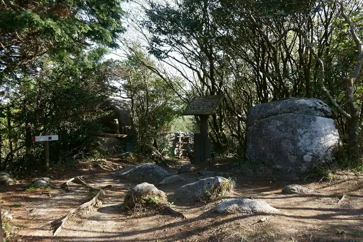
An 862.8-meter peak on the boundary between Yoshinogari Town (Kanzaki District, Saga) and Nakagawa City (Fukuoka), at the eastern end of the Seburi Range. A 3-to-4-meter granite boulder called Hamaguri-iwa sits on the summit, split east–west into the shape of an open clam — the source of the mountain's name. The Kyushu Nature Trail crosses the summit ridge from Sakamoto Pass on Route 385 onward to Mt. Seburi, and partway down the mountain runs the Hamaguri-suidō, a 1626 water-diversion canal built by Saga-han retainer Naritomi Shigeyasu and designated a Civil Engineering Heritage in 2010. The peak lies within Seburi-Kitayama Prefectural Natural Park. Listed in the Bunken Tozan Guide volume for Saga Prefecture.
Hamaguridake at a glance
- Weather: The most settled day in the next 7 days is Sun, November 8: clear, gusts up to 5 m/s. Fri, Nov 6: strong wind (gusts up to 16 m/s).
Hamaguridake weather (hourly, 14 days)
Sunrise today 06:38, sunset 17:26
| Tue, 11/3 | Wed, 11/4 | Thu, 11/5 | Fri, 11/6 | Sat, 11/7 | Sun, 11/8 | Mon, 11/9 | Tue, 11/10 | Wed, 11/11 | Thu, 11/12 | Fri, 11/13 | Sat, 11/14 | Sun, 11/15 | Mon, 11/16 | Tue, 11/17 | |||||||||||||||||||||||||||||||||||||||||||||||||||||||||||||||||||||||
|---|---|---|---|---|---|---|---|---|---|---|---|---|---|---|---|---|---|---|---|---|---|---|---|---|---|---|---|---|---|---|---|---|---|---|---|---|---|---|---|---|---|---|---|---|---|---|---|---|---|---|---|---|---|---|---|---|---|---|---|---|---|---|---|---|---|---|---|---|---|---|---|---|---|---|---|---|---|---|---|---|---|---|---|---|---|
| Japan time | 15 | 17 | 19 | 21 | 23 | 1 | 3 | 5 | 7 | 9 | 11 | 13 | 15 | 18 | 21 | 0 | 3 | 6 | 9 | 12 | 15 | 18 | 21 | 0 | 3 | 6 | 9 | 12 | 15 | 18 | 21 | 0 | 3 | 6 | 9 | 12 | 15 | 18 | 21 | 0 | 3 | 6 | 9 | 12 | 15 | 18 | 21 | 0 | 3 | 6 | 9 | 15 | 21 | 3 | 9 | 15 | 21 | 3 | 9 | 15 | 21 | 3 | 9 | 15 | 21 | 3 | 9 | 15 | 21 | 3 | 9 | 15 | 21 | 3 | 9 | 15 | 21 | 3 | 9 | 15 | 21 | 3 | 9 | 15 | |
  |   |   | | |   | | | |   | | | |   | | | | | |   | |   | | |   | | |   |  |  | | | | | | | | | | | | | | | | | | | | |   | | | | | |   | | | |   | | | |  | | | | | | | | | | | | | | | | | | | | ||
| Temperature | °C | 14° | 12° | 10° | 10° | 10° | 9° | 9° | 9° | 8° | 11° | 14° | 16° | 15° | 12° | 12° | 12° | 12° | 12° | 14° | 15° | 16° | 15° | 14° | 13° | 12° | 10° | 13° | 14° | 11° | 8° | 8° | 6° | 5° | 5° | 7° | 9° | 8° | 5° | 4° | 4° | 4° | 4° | 9° | 11° | 11° | 9° | 8° | 8° | 8° | 8° | 10° | 11° | 7° | 6° | 9° | 10° | 8° | 6° | 7° | 9° | 5° | 3° | 9° | 11° | 5° | 6° | 11° | 12° | 7° | 6° | 10° | 15° | 10° | 10° | 12° | 14° | 11° | 12° | 12° | 13° | 8° | 7° | 9° | 12° |
| Precipitation | mm | 0.7 | 0.8 | 0.2 | 2.2 | 1.3 | 2.4 | 0.6 | 0.7 | 1.1 | 0.2 | 0.2 | 0.6 | 0.2 | 0.5 | 1.0 | 0.2 | 0.5 | 8 | 17 | 11 | 1.7 | 2.3 | 0.3 | 0.3 | ||||||||||||||||||||||||||||||||||||||||||||||||||||||||||||
| New snow | cm | ||||||||||||||||||||||||||||||||||||||||||||||||||||||||||||||||||||||||||||||||||||
| Snow depth | cm | 0 | 0 | 0 | 0 | 0 | 0 | 0 | 0 | 0 | 0 | 0 | 0 | 0 | 0 | 0 | 0 | 0 | 0 | 0 | 0 | 0 | 0 | 0 | 0 | 0 | 0 | 0 | 0 | 0 | 0 | 0 | 0 | 0 | 0 | 0 | 0 | 0 | 0 | 0 | 0 | 0 | 0 | 0 | 0 | 0 | 0 | 0 | 0 | 0 | 0 | 0 | 0 | 0 | 0 | 0 | 0 | 0 | 0 | 0 | 0 | 0 | 0 | 0 | 0 | 0 | 0 | 0 | 0 | 0 | 0 | 0 | 0 | 0 | 0 | 0 | 0 | 0 | 0 | 0 | 0 | 0 | 0 | 0 | 0 |
| Wind | m/s | 4 | 3 | 2 | 2 | 2 | 2 | 2 | 2 | 1 | 1 | 2 | 1 | 2 | 1 | 1 | 1 | 1 | 1 | 2 | 4 | 3 | 2 | 2 | 2 | 4 | 4 | 4 | 6 | 5 | 4 | 4 | 5 | 5 | 5 | 5 | 4 | 4 | 2 | 1 | 1 | 1 | 1 | 1 | 1 | 2 | 1 | 0 | 1 | 1 | 1 | 2 | 4 | 1 | 1 | 3 | 5 | 3 | 3 | 3 | 4 | 0 | 0 | 0 | 2 | 1 | 1 | 2 | 3 | 1 | 1 | 1 | 2 | 1 | 2 | 5 | 3 | 1 | 2 | 3 | 5 | 3 | 2 | 3 | 4 |
| Wind gusts | m/s | 11 | 10 | 8 | 7 | 7 | 7 | 6 | 7 | 5 | 5 | 7 | 6 | 6 | 6 | 5 | 5 | 4 | 3 | 7 | 13 | 15 | 9 | 8 | 8 | 11 | 11 | 11 | 15 | 16 | 14 | 11 | 15 | 15 | 14 | 14 | 14 | 13 | 11 | 5 | 4 | 4 | 4 | 4 | 5 | 5 | 4 | 3 | 2 | 4 | 6 | 6 | 11 | 11 | 5 | 9 | 14 | 14 | 12 | 10 | 11 | 10 | 2 | 3 | 7 | 7 | 4 | 6 | 8 | 8 | 4 | 5 | 9 | 7 | 6 | 14 | 16 | 10 | 7 | 9 | 13 | 13 | 8 | 7 | 10 |
| Wind dir. | ↓ | ↓ | ↓ | ↓ | ↓ | ↓ | ↓ | ↓ | ↓ | ↓ | ↓ | ↓ | ↓ | ↓ | ↓ | ↓ | ↓ | ↓ | ↓ | ↓ | ↓ | ↓ | ↓ | ↓ | ↓ | ↓ | ↓ | ↓ | ↓ | ↓ | ↓ | ↓ | ↓ | ↓ | ↓ | ↓ | ↓ | ↓ | ↓ | ↓ | ↓ | ↓ | ↓ | ↓ | ↓ | ↓ | ↓ | ↓ | ↓ | ↓ | ↓ | ↓ | ↓ | ↓ | ↓ | ↓ | ↓ | ↓ | ↓ | ↓ | ↓ | ↓ | ↓ | ↓ | ↓ | ↓ | ↓ | ↓ | ↓ | ↓ | ↓ | ↓ | ↓ | ↓ | ↓ | ↓ | ↓ | ↓ | ↓ | ↓ | ↓ | ↓ | ↓ | ↓ | |
Huts, campsites and lodging near Hamaguridake
Campsites
- モンベルクライミングウォール那珂川町
Hamaguridake facts
- Elevation
- 863 m
- Location
- Yoshinogari, Saga / Kanzaki, Saga
33.409484, 130.384921 - Website
- www.town.yoshinogari.lg.jp
- Trail Map
- www.town.yoshinogari.lg.jp (PDF)
- Wikipedia
- ja.wikipedia.org