
Mt. Wakakusayama
若草山
Nara, Nara · Elevation 342 m
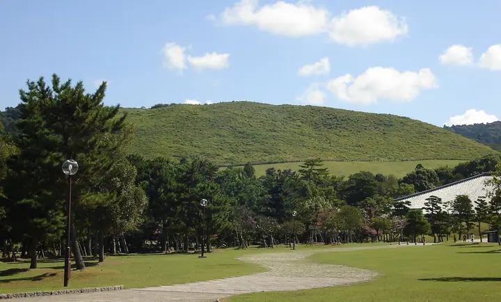
Wakakusayama is a 342 m grass-covered hill in Nara Park, Nara City, made up of three tiered slopes that give it the alternate name Mikasayama. The summit holds the 5th-century Uguisuzuka Tumulus and the mountain hosts the famous Yamayaki burning festival each January. Public access is limited to the official open season — from the third Saturday of March until the second Sunday of December — and the peak appears in the Nara Prefecture and Nara 100 hiking guides.
Mt. Wakakusayama at a glance
- Weather: The most settled day in the next 7 days is Thu, November 5: cloudy, gusts up to 5 m/s.
- Route: The shortest is Kasuga Taisha Approach to Mount Wakakusa and Nara Park: about 2 h 15 min, 5.4 km, about 260 m of climbing.
Mt. Wakakusayama weather (hourly, 14 days)
Sunrise today 06:18, sunset 17:02
| Tue, 11/3 | Wed, 11/4 | Thu, 11/5 | Fri, 11/6 | Sat, 11/7 | Sun, 11/8 | Mon, 11/9 | Tue, 11/10 | Wed, 11/11 | Thu, 11/12 | Fri, 11/13 | Sat, 11/14 | Sun, 11/15 | Mon, 11/16 | Tue, 11/17 | |||||||||||||||||||||||||||||||||||||||||||||||||||||||||||||||||||||||
|---|---|---|---|---|---|---|---|---|---|---|---|---|---|---|---|---|---|---|---|---|---|---|---|---|---|---|---|---|---|---|---|---|---|---|---|---|---|---|---|---|---|---|---|---|---|---|---|---|---|---|---|---|---|---|---|---|---|---|---|---|---|---|---|---|---|---|---|---|---|---|---|---|---|---|---|---|---|---|---|---|---|---|---|---|---|
| Japan time | 15 | 17 | 19 | 21 | 23 | 1 | 3 | 5 | 7 | 9 | 11 | 13 | 15 | 18 | 21 | 0 | 3 | 6 | 9 | 12 | 15 | 18 | 21 | 0 | 3 | 6 | 9 | 12 | 15 | 18 | 21 | 0 | 3 | 6 | 9 | 12 | 15 | 18 | 21 | 0 | 3 | 6 | 9 | 12 | 15 | 18 | 21 | 0 | 3 | 6 | 9 | 15 | 21 | 3 | 9 | 15 | 21 | 3 | 9 | 15 | 21 | 3 | 9 | 15 | 21 | 3 | 9 | 15 | 21 | 3 | 9 | 15 | 21 | 3 | 9 | 15 | 21 | 3 | 9 | 15 | 21 | 3 | 9 | 15 | |
  | |   | | | | | | |   | | |   |   | |   | |   |   | | | |  |   | |   |  | |   | | | | | | | | | | | | | | | | | | | | | | | | |   | | | | | | | |  | | | | | | | | | | | | | | | | | | | |  | | | ||
| Temperature | °C | 17° | 14° | 12° | 11° | 10° | 9° | 8° | 8° | 8° | 13° | 16° | 17° | 16° | 14° | 14° | 14° | 14° | 13° | 16° | 17° | 19° | 16° | 14° | 14° | 15° | 14° | 16° | 18° | 18° | 15° | 11° | 10° | 8° | 8° | 10° | 12° | 12° | 8° | 6° | 5° | 5° | 4° | 10° | 13° | 12° | 9° | 9° | 9° | 8° | 9° | 12° | 14° | 9° | 8° | 12° | 14° | 9° | 7° | 9° | 11° | 6° | 4° | 9° | 12° | 7° | 6° | 10° | 12° | 6° | 3° | 10° | 15° | 7° | 6° | 14° | 16° | 12° | 12° | 14° | 16° | 10° | 6° | 9° | 12° |
| Precipitation | mm | 1.1 | 0.4 | 0.1 | 0.4 | 0.2 | 3.8 | 0.8 | 0.3 | 0.3 | 0.3 | 0.2 | 0.2 | 0.8 | 17 | 0.4 | 0.8 | ||||||||||||||||||||||||||||||||||||||||||||||||||||||||||||||||||||
| New snow | cm | ||||||||||||||||||||||||||||||||||||||||||||||||||||||||||||||||||||||||||||||||||||
| Snow depth | cm | 0 | 0 | 0 | 0 | 0 | 0 | 0 | 0 | 0 | 0 | 0 | 0 | 0 | 0 | 0 | 0 | 0 | 0 | 0 | 0 | 0 | 0 | 0 | 0 | 0 | 0 | 0 | 0 | 0 | 0 | 0 | 0 | 0 | 0 | 0 | 0 | 0 | 0 | 0 | 0 | 0 | 0 | 0 | 0 | 0 | 0 | 0 | 0 | 0 | 0 | 0 | 0 | 0 | 0 | 0 | 0 | 0 | 0 | 0 | 0 | 0 | 0 | 0 | 0 | 0 | 0 | 0 | 0 | 0 | 0 | 0 | 0 | 0 | 0 | 0 | 0 | 0 | 0 | 0 | 0 | 0 | 0 | 0 | 0 |
| Wind | m/s | 3 | 2 | 2 | 1 | 1 | 1 | 1 | 1 | 1 | 1 | 2 | 3 | 3 | 4 | 5 | 3 | 4 | 2 | 1 | 1 | 1 | 0 | 1 | 1 | 3 | 2 | 4 | 5 | 5 | 4 | 3 | 3 | 3 | 3 | 4 | 6 | 5 | 3 | 1 | 1 | 1 | 1 | 1 | 3 | 3 | 1 | 0 | 0 | 1 | 1 | 1 | 3 | 1 | 1 | 2 | 4 | 2 | 4 | 3 | 6 | 1 | 1 | 1 | 2 | 2 | 2 | 1 | 5 | 1 | 1 | 0 | 2 | 1 | 2 | 2 | 3 | 2 | 2 | 2 | 5 | 3 | 1 | 1 | 2 |
| Wind gusts | m/s | 7 | 7 | 6 | 4 | 3 | 2 | 3 | 2 | 2 | 4 | 5 | 8 | 8 | 10 | 11 | 10 | 9 | 8 | 4 | 4 | 5 | 3 | 2 | 4 | 8 | 8 | 9 | 11 | 12 | 11 | 10 | 8 | 8 | 6 | 10 | 13 | 14 | 12 | 7 | 3 | 3 | 3 | 3 | 8 | 9 | 7 | 2 | 1 | 1 | 2 | 4 | 7 | 6 | 3 | 6 | 11 | 10 | 10 | 10 | 15 | 14 | 3 | 4 | 6 | 6 | 4 | 5 | 12 | 11 | 2 | 3 | 6 | 5 | 3 | 5 | 10 | 6 | 6 | 6 | 13 | 12 | 6 | 4 | 6 |
| Wind dir. | ↓ | ↓ | ↓ | ↓ | ↓ | ↓ | ↓ | ↓ | ↓ | ↓ | ↓ | ↓ | ↓ | ↓ | ↓ | ↓ | ↓ | ↓ | ↓ | ↓ | ↓ | ↓ | ↓ | ↓ | ↓ | ↓ | ↓ | ↓ | ↓ | ↓ | ↓ | ↓ | ↓ | ↓ | ↓ | ↓ | ↓ | ↓ | ↓ | ↓ | ↓ | ↓ | ↓ | ↓ | ↓ | ↓ | ↓ | ↓ | ↓ | ↓ | ↓ | ↓ | ↓ | ↓ | ↓ | ↓ | ↓ | ↓ | ↓ | ↓ | ↓ | ↓ | ↓ | ↓ | ↓ | ↓ | ↓ | ↓ | ↓ | ↓ | ↓ | ↓ | ↓ | ↓ | ↓ | ↓ | ↓ | ↓ | ↓ | ↓ | ↓ | ↓ | ↓ | ↓ | |
Mt. Wakakusayama hiking routes
- Kasuga Taisha Approach to Mount Wakakusa and Nara Park 5.4 km · Ascent 257 m Kasuga-taisha Omotesando (Bus stop), Daibutsuden Kasugataisha-mae (Bus stop), Todaiji Daibutsuden (Bus stop), Todaiji Daibutsuden & Kokuritsu Hakubutsukan (Bus stop) → parking
- Mount Wakakusa via the Kasugayama Promenade 6.2 km · Ascent 261 m Kasuga-taisha Honden (Bus stop), Kasuga Taisha Honden (Bus station) (parking)
- Kasuga Taisha Shrine, Kasugayama Primeval Forest, and Mount Wakakusa Loop 11.3 km · Ascent 478 m パーキング上高畑 (parking)
Hiking times are estimates calculated from the terrain.
Huts, campsites and lodging near Mt. Wakakusayama
Mountain huts
- 無料休憩スペース
Lodging
- Tsukihitei
- Mikasa Ryokan
- The Deer Park Inn
- 遊景の宿 平城
- ホテルたまる
Lists that include Mt. Wakakusayama
Nara 100 Mountains to Explore · Elevations of 1003 Mountains of Japan
Mt. Wakakusayama facts
- Also known as
- 三笠山
- Elevation
- 342 m
- Location
- Nara, Nara
34.691173, 135.854267 - Season Opens
- March 15
- Season Closes
- December 14
- Website
- www.pref.nara.lg.jp
- Trail Map
- www.pref.nara.lg.jp (PDF)
- Wikipedia
- ja.wikipedia.org