
Mt. Unpenji
雲辺寺山
Miyoshi, Tokushima / Kan'onji, Kagawa · Elevation 927 m
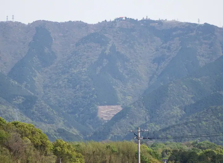
A 927-meter peak on the northern edge of the Shikoku Mountains, straddling the border between Miyoshi City (Tokushima) and Kannonji City (Kagawa). Just below the summit on the Tokushima side stands Unpen-ji — the 66th temple of the Shikoku Pilgrimage and, at 911 m, the highest of the 88 sacred places, sometimes called the "Kōya of Shikoku." The Kagawa-side summit park hosts photogenic installations such as the "Sky Swing" and "Sky Frame," linked to the foot of the mountain by the 2,594-meter Unpenji Ropeway — one of Japan's longest — that climbs in roughly seven minutes. The summit overlooks the Seto Inland Sea, the Mitoyo Plain, the Great Seto Bridge and the Chūgoku coast beyond. Listed in the Shikoku 100 Famous Mountains, the Bunken Tozan Guide for Kagawa, Nihon no Yama 1000 and Shikoku Hyakuzan.
Mt. Unpenji at a glance
- Weather: The most settled day in the next 7 days is Sun, November 8: clear, gusts up to 9 m/s.
Mt. Unpenji weather (hourly, 14 days)
Sunrise today 06:26, sunset 17:12
| Tue, 11/3 | Wed, 11/4 | Thu, 11/5 | Fri, 11/6 | Sat, 11/7 | Sun, 11/8 | Mon, 11/9 | Tue, 11/10 | Wed, 11/11 | Thu, 11/12 | Fri, 11/13 | Sat, 11/14 | Sun, 11/15 | Mon, 11/16 | Tue, 11/17 | |||||||||||||||||||||||||||||||||||||||||||||||||||||||||||||||||||||||
|---|---|---|---|---|---|---|---|---|---|---|---|---|---|---|---|---|---|---|---|---|---|---|---|---|---|---|---|---|---|---|---|---|---|---|---|---|---|---|---|---|---|---|---|---|---|---|---|---|---|---|---|---|---|---|---|---|---|---|---|---|---|---|---|---|---|---|---|---|---|---|---|---|---|---|---|---|---|---|---|---|---|---|---|---|---|
| Japan time | 21 | 23 | 1 | 3 | 5 | 7 | 9 | 11 | 13 | 15 | 17 | 19 | 21 | 0 | 3 | 6 | 9 | 12 | 15 | 18 | 21 | 0 | 3 | 6 | 9 | 12 | 15 | 18 | 21 | 0 | 3 | 6 | 9 | 12 | 15 | 18 | 21 | 0 | 3 | 6 | 9 | 12 | 15 | 18 | 21 | 0 | 3 | 6 | 9 | 12 | 15 | 21 | 3 | 9 | 15 | 21 | 3 | 9 | 15 | 21 | 3 | 9 | 15 | 21 | 3 | 9 | 15 | 21 | 3 | 9 | 15 | 21 | 3 | 9 | 15 | 21 | 3 | 9 | 15 | 21 | 3 | 9 | 15 | 21 | |
  |   |   | | |   | | |   | | | | |   |   | |   | |   | | | |   | | | | | | | |  | | | | | | | | | | | | | | | | | | |   | | | | | | | | | | | | |  | | | | |  | | | | | | | | | | | | |  | | | | ||
| Temperature | °C | 8° | 8° | 7° | 8° | 8° | 8° | 11° | 13° | 13° | 13° | 10° | 10° | 9° | 10° | 9° | 9° | 12° | 17° | 17° | 13° | 13° | 12° | 11° | 10° | 12° | 13° | 14° | 11° | 8° | 6° | 6° | 6° | 8° | 9° | 10° | 6° | 4° | 2° | 1° | 2° | 8° | 10° | 10° | 5° | 6° | 6° | 5° | 6° | 10° | 11° | 10° | 7° | 4° | 9° | 10° | 5° | 4° | 6° | 9° | 5° | 0° | 7° | 10° | 4° | 5° | 8° | 10° | 3° | -1° | 8° | 12° | 4° | 4° | 13° | 15° | 11° | 11° | 12° | 14° | 7° | 4° | 6° | 9° | 1° |
| Precipitation | mm | 0.2 | 1.7 | 1.8 | 0.2 | 0.5 | 2.4 | 0.7 | 0.5 | 1.2 | 1.4 | 0.4 | 0.7 | 0.1 | 0.4 | 0.8 | 0.1 | 0.4 | 1.4 | 0.1 | 0.4 | 0.3 | 2.5 | 1.2 | 1.1 | 0.6 | |||||||||||||||||||||||||||||||||||||||||||||||||||||||||||
| New snow | cm | ||||||||||||||||||||||||||||||||||||||||||||||||||||||||||||||||||||||||||||||||||||
| Snow depth | cm | 0 | 0 | 0 | 0 | 0 | 0 | 0 | 0 | 0 | 0 | 0 | 0 | 0 | 0 | 0 | 0 | 0 | 0 | 0 | 0 | 0 | 0 | 0 | 0 | 0 | 0 | 0 | 0 | 0 | 0 | 0 | 0 | 0 | 0 | 0 | 0 | 0 | 0 | 0 | 0 | 0 | 0 | 0 | 0 | 0 | 0 | 0 | 0 | 0 | 0 | 0 | 0 | 0 | 0 | 0 | 0 | 0 | 0 | 0 | 0 | 0 | 0 | 0 | 0 | 0 | 0 | 0 | 0 | 0 | 0 | 0 | 0 | 0 | 0 | 0 | 0 | 0 | 0 | 0 | 0 | 0 | 0 | 0 | 0 |
| Wind | m/s | 1 | 1 | 2 | 2 | 2 | 2 | 3 | 3 | 3 | 2 | 1 | 2 | 1 | 2 | 1 | 0 | 0 | 1 | 1 | 1 | 2 | 1 | 4 | 4 | 5 | 5 | 5 | 4 | 3 | 3 | 3 | 4 | 4 | 4 | 4 | 1 | 2 | 2 | 1 | 1 | 2 | 3 | 3 | 1 | 1 | 1 | 1 | 1 | 1 | 3 | 1 | 2 | 2 | 2 | 3 | 3 | 3 | 3 | 3 | 1 | 1 | 1 | 2 | 1 | 1 | 2 | 3 | 1 | 1 | 1 | 2 | 2 | 2 | 2 | 3 | 2 | 1 | 3 | 3 | 2 | 1 | 1 | 2 | 1 |
| Wind gusts | m/s | 2 | 4 | 5 | 5 | 6 | 7 | 9 | 11 | 9 | 8 | 6 | 4 | 4 | 4 | 4 | 3 | 3 | 5 | 5 | 5 | 7 | 7 | 14 | 11 | 14 | 14 | 15 | 14 | 12 | 9 | 10 | 11 | 12 | 12 | 11 | 10 | 7 | 5 | 3 | 4 | 7 | 9 | 8 | 8 | 5 | 4 | 3 | 3 | 4 | 8 | 8 | 7 | 5 | 7 | 11 | 10 | 11 | 9 | 10 | 8 | 3 | 4 | 7 | 6 | 4 | 5 | 9 | 8 | 5 | 5 | 7 | 6 | 6 | 6 | 11 | 10 | 8 | 10 | 12 | 10 | 7 | 4 | 7 | 6 |
| Wind dir. | ↓ | ↓ | ↓ | ↓ | ↓ | ↓ | ↓ | ↓ | ↓ | ↓ | ↓ | ↓ | ↓ | ↓ | ↓ | ↓ | ↓ | ↓ | ↓ | ↓ | ↓ | ↓ | ↓ | ↓ | ↓ | ↓ | ↓ | ↓ | ↓ | ↓ | ↓ | ↓ | ↓ | ↓ | ↓ | ↓ | ↓ | ↓ | ↓ | ↓ | ↓ | ↓ | ↓ | ↓ | ↓ | ↓ | ↓ | ↓ | ↓ | ↓ | ↓ | ↓ | ↓ | ↓ | ↓ | ↓ | ↓ | ↓ | ↓ | ↓ | ↓ | ↓ | ↓ | ↓ | ↓ | ↓ | ↓ | ↓ | ↓ | ↓ | ↓ | ↓ | ↓ | ↓ | ↓ | ↓ | ↓ | ↓ | ↓ | ↓ | ↓ | ↓ | ↓ | ↓ | |
Lists that include Mt. Unpenji
Shikoku 100 Famous Mountains · Elevations of 1003 Mountains of Japan · 1000 Mountains of Japan
Mt. Unpenji facts
- Elevation
- 927 m
- Location
- Miyoshi, Tokushima / Kan'onji, Kagawa
34.035128, 133.722920 - Website
- www.city.kanonji.kagawa.jp