
Mt. Unpenji
雲辺寺山
มิโยชิ, โทกูชิมะ / คังอนจิ, คางาวะ · ความสูง 927 ม.
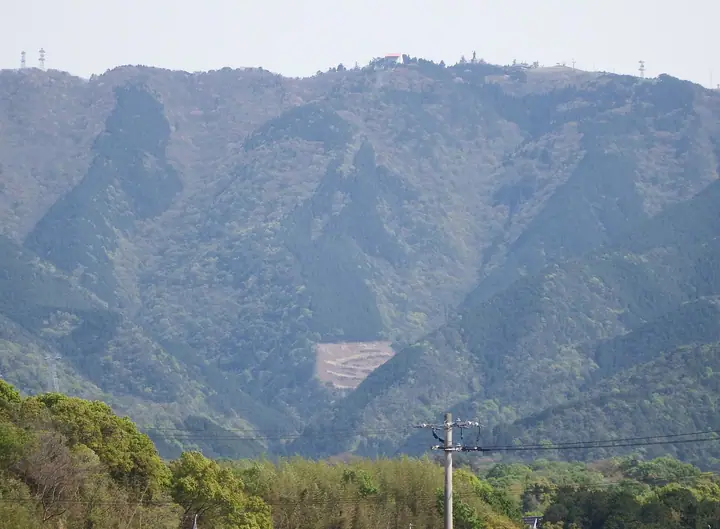
A 927-meter peak on the northern edge of the Shikoku Mountains, straddling the border between Miyoshi City (Tokushima) and Kannonji City (Kagawa). Just below the summit on the Tokushima side stands Unpen-ji — the 66th temple of the Shikoku Pilgrimage and, at 911 m, the highest of the 88 sacred places, sometimes called the "Kōya of Shikoku." The Kagawa-side summit park hosts photogenic installations such as the "Sky Swing" and "Sky Frame," linked to the foot of the mountain by the 2,594-meter Unpenji Ropeway — one of Japan's longest — that climbs in roughly seven minutes. The summit overlooks the Seto Inland Sea, the Mitoyo Plain, the Great Seto Bridge and the Chūgoku coast beyond. Listed in the Shikoku 100 Famous Mountains, the Bunken Tozan Guide for Kagawa, Nihon no Yama 1000 and Shikoku Hyakuzan.
สรุป Mt. Unpenji
- อากาศ: วันที่อากาศคงที่ที่สุดใน 7 วันข้างหน้าคือ อาทิตย์ 8 พฤศจิกายน: ท้องฟ้าแจ่มใส ลมกระโชกสูงสุด 9 ม./วินาที
อากาศ Mt. Unpenji (รายชั่วโมง 2 สัปดาห์)
วันนี้พระอาทิตย์ขึ้น 06:26 ตก 17:12
| อังคาร 3/11 | พุธ 4/11 | พฤหัส 5/11 | ศุกร์ 6/11 | เสาร์ 7/11 | อาทิตย์ 8/11 | จันทร์ 9/11 | อังคาร 10/11 | พุธ 11/11 | พฤหัส 12/11 | ศุกร์ 13/11 | เสาร์ 14/11 | อาทิตย์ 15/11 | จันทร์ 16/11 | อังคาร 17/11 | |||||||||||||||||||||||||||||||||||||||||||||||||||||||||||||||||||||||
|---|---|---|---|---|---|---|---|---|---|---|---|---|---|---|---|---|---|---|---|---|---|---|---|---|---|---|---|---|---|---|---|---|---|---|---|---|---|---|---|---|---|---|---|---|---|---|---|---|---|---|---|---|---|---|---|---|---|---|---|---|---|---|---|---|---|---|---|---|---|---|---|---|---|---|---|---|---|---|---|---|---|---|---|---|---|
| เวลาญี่ปุ่น | 21 | 23 | 1 | 3 | 5 | 7 | 9 | 11 | 13 | 15 | 17 | 19 | 21 | 0 | 3 | 6 | 9 | 12 | 15 | 18 | 21 | 0 | 3 | 6 | 9 | 12 | 15 | 18 | 21 | 0 | 3 | 6 | 9 | 12 | 15 | 18 | 21 | 0 | 3 | 6 | 9 | 12 | 15 | 18 | 21 | 0 | 3 | 6 | 9 | 12 | 15 | 21 | 3 | 9 | 15 | 21 | 3 | 9 | 15 | 21 | 3 | 9 | 15 | 21 | 3 | 9 | 15 | 21 | 3 | 9 | 15 | 21 | 3 | 9 | 15 | 21 | 3 | 9 | 15 | 21 | 3 | 9 | 15 | 21 | |
  |   |   | | |   | | |   | | | | |   |   | |   | |   | | | |   | | | | | | | |  | | | | | | | | | | | | | | | | | | |   | | | | | | | | | | | | |  | | | | |  | | | | | | | | | | | | |  | | | | ||
| อุณหภูมิ | °C | 8° | 8° | 7° | 8° | 8° | 8° | 11° | 13° | 13° | 13° | 10° | 10° | 9° | 10° | 9° | 9° | 12° | 17° | 17° | 13° | 13° | 12° | 11° | 10° | 12° | 13° | 14° | 11° | 8° | 6° | 6° | 6° | 8° | 9° | 10° | 6° | 4° | 2° | 1° | 2° | 8° | 10° | 10° | 5° | 6° | 6° | 5° | 6° | 10° | 11° | 10° | 7° | 4° | 9° | 10° | 5° | 4° | 6° | 9° | 5° | 0° | 7° | 10° | 4° | 5° | 8° | 10° | 3° | -1° | 8° | 12° | 4° | 4° | 13° | 15° | 11° | 11° | 12° | 14° | 7° | 4° | 6° | 9° | 1° |
| ฝนและหิมะ | mm | 0.2 | 1.7 | 1.8 | 0.2 | 0.5 | 2.4 | 0.7 | 0.5 | 1.2 | 1.4 | 0.4 | 0.7 | 0.1 | 0.4 | 0.8 | 0.1 | 0.4 | 1.4 | 0.1 | 0.4 | 0.3 | 2.5 | 1.2 | 1.1 | 0.6 | |||||||||||||||||||||||||||||||||||||||||||||||||||||||||||
| หิมะตก | cm | ||||||||||||||||||||||||||||||||||||||||||||||||||||||||||||||||||||||||||||||||||||
| หิมะสะสม | cm | 0 | 0 | 0 | 0 | 0 | 0 | 0 | 0 | 0 | 0 | 0 | 0 | 0 | 0 | 0 | 0 | 0 | 0 | 0 | 0 | 0 | 0 | 0 | 0 | 0 | 0 | 0 | 0 | 0 | 0 | 0 | 0 | 0 | 0 | 0 | 0 | 0 | 0 | 0 | 0 | 0 | 0 | 0 | 0 | 0 | 0 | 0 | 0 | 0 | 0 | 0 | 0 | 0 | 0 | 0 | 0 | 0 | 0 | 0 | 0 | 0 | 0 | 0 | 0 | 0 | 0 | 0 | 0 | 0 | 0 | 0 | 0 | 0 | 0 | 0 | 0 | 0 | 0 | 0 | 0 | 0 | 0 | 0 | 0 |
| ลม | m/s | 1 | 1 | 2 | 2 | 2 | 2 | 3 | 3 | 3 | 2 | 1 | 2 | 1 | 2 | 1 | 0 | 0 | 1 | 1 | 1 | 2 | 1 | 4 | 4 | 5 | 5 | 5 | 4 | 3 | 3 | 3 | 4 | 4 | 4 | 4 | 1 | 2 | 2 | 1 | 1 | 2 | 3 | 3 | 1 | 1 | 1 | 1 | 1 | 1 | 3 | 1 | 2 | 2 | 2 | 3 | 3 | 3 | 3 | 3 | 1 | 1 | 1 | 2 | 1 | 1 | 2 | 3 | 1 | 1 | 1 | 2 | 2 | 2 | 2 | 3 | 2 | 1 | 3 | 3 | 2 | 1 | 1 | 2 | 1 |
| ลมกระโชก | m/s | 2 | 4 | 5 | 5 | 6 | 7 | 9 | 11 | 9 | 8 | 6 | 4 | 4 | 4 | 4 | 3 | 3 | 5 | 5 | 5 | 7 | 7 | 14 | 11 | 14 | 14 | 15 | 14 | 12 | 9 | 10 | 11 | 12 | 12 | 11 | 10 | 7 | 5 | 3 | 4 | 7 | 9 | 8 | 8 | 5 | 4 | 3 | 3 | 4 | 8 | 8 | 7 | 5 | 7 | 11 | 10 | 11 | 9 | 10 | 8 | 3 | 4 | 7 | 6 | 4 | 5 | 9 | 8 | 5 | 5 | 7 | 6 | 6 | 6 | 11 | 10 | 8 | 10 | 12 | 10 | 7 | 4 | 7 | 6 |
| ทิศทางลม | ↓ | ↓ | ↓ | ↓ | ↓ | ↓ | ↓ | ↓ | ↓ | ↓ | ↓ | ↓ | ↓ | ↓ | ↓ | ↓ | ↓ | ↓ | ↓ | ↓ | ↓ | ↓ | ↓ | ↓ | ↓ | ↓ | ↓ | ↓ | ↓ | ↓ | ↓ | ↓ | ↓ | ↓ | ↓ | ↓ | ↓ | ↓ | ↓ | ↓ | ↓ | ↓ | ↓ | ↓ | ↓ | ↓ | ↓ | ↓ | ↓ | ↓ | ↓ | ↓ | ↓ | ↓ | ↓ | ↓ | ↓ | ↓ | ↓ | ↓ | ↓ | ↓ | ↓ | ↓ | ↓ | ↓ | ↓ | ↓ | ↓ | ↓ | ↓ | ↓ | ↓ | ↓ | ↓ | ↓ | ↓ | ↓ | ↓ | ↓ | ↓ | ↓ | ↓ | ↓ | |
รายชื่อที่มี Mt. Unpenji
100 ภูเขาที่มีชื่อเสียงของชิโกกุ · ระดับความสูงของภูเขา 1003 แห่งในญี่ปุ่น · ภูเขา 1000 แห่งของญี่ปุ่น
ข้อมูลพื้นฐาน Mt. Unpenji
- ความสูง
- 927 ม.
- ที่ตั้ง
- มิโยชิ, โทกูชิมะ / คังอนจิ, คางาวะ
34.035128, 133.722920 - เว็บไซต์
- www.city.kanonji.kagawa.jp