
Mt. Tabashineyama
束稲山
Ichinoseki, Iwate · Elevation 595 m
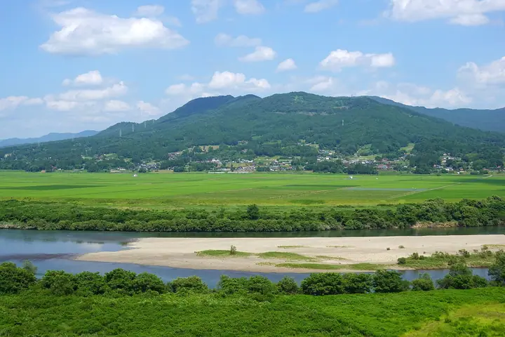
Mt. Tabashineyama is a 594.9-meter peak at the meeting point of Ichinoseki City, Ōshū City, and Hiraizumi Town in Iwate Prefecture, forming the southwestern edge of the Kitakami Mountains and sometimes treated as a collective name for the three peaks of Kyōzukasan, Otowayama, and Tabashineyama. Long famed for its cherry blossoms — celebrated in a poem by the priest-poet Saigyō — the area was designated a national "Place of Scenic Beauty" in 2015 as "Sakurayama (Tabashineyama)" within the Oku-no-Hosomichi scenic-spots series. The base hosts a statue of the Emishi chief Aterui and Gassan Shrine, and the slopes are lit each August 16 by the Hiraizumi Daimonji bonfire send-off. The mountain is included in the Iwate Hyakumeizan and Iwate-no-Yama 150 lists.
Mt. Tabashineyama at a glance
- Weather: The most settled day in the next 7 days is Wed, November 4: clear, gusts up to 5 m/s.
Mt. Tabashineyama weather (hourly, 14 days)
Sunrise today 06:04, sunset 16:34
| Tue, 11/3 | Wed, 11/4 | Thu, 11/5 | Fri, 11/6 | Sat, 11/7 | Sun, 11/8 | Mon, 11/9 | Tue, 11/10 | Wed, 11/11 | Thu, 11/12 | Fri, 11/13 | Sat, 11/14 | Sun, 11/15 | Mon, 11/16 | Tue, 11/17 | |||||||||||||||||||||||||||||||||||||||||||||||||||||||||||||||||||||||
|---|---|---|---|---|---|---|---|---|---|---|---|---|---|---|---|---|---|---|---|---|---|---|---|---|---|---|---|---|---|---|---|---|---|---|---|---|---|---|---|---|---|---|---|---|---|---|---|---|---|---|---|---|---|---|---|---|---|---|---|---|---|---|---|---|---|---|---|---|---|---|---|---|---|---|---|---|---|---|---|---|---|---|---|---|---|
| Japan time | 15 | 17 | 19 | 21 | 23 | 1 | 3 | 5 | 7 | 9 | 11 | 13 | 15 | 18 | 21 | 0 | 3 | 6 | 9 | 12 | 15 | 18 | 21 | 0 | 3 | 6 | 9 | 12 | 15 | 18 | 21 | 0 | 3 | 6 | 9 | 12 | 15 | 18 | 21 | 0 | 3 | 6 | 9 | 12 | 15 | 18 | 21 | 0 | 3 | 6 | 9 | 15 | 21 | 3 | 9 | 15 | 21 | 3 | 9 | 15 | 21 | 3 | 9 | 15 | 21 | 3 | 9 | 15 | 21 | 3 | 9 | 15 | 21 | 3 | 9 | 15 | 21 | 3 | 9 | 15 | 21 | 3 | 9 | 15 | |
 |  | | | | | |   |   | |   | | | | | |   |   |   | | | | | |   | |   | | | | | | | |   | | | | | | | | | | | | |   | | | | | | | |   | | | | |   | | | |  | | | | | | | | | | | | |   | | | | | | | ||
| Temperature | °C | 10° | 6° | 5° | 3° | 2° | 1° | 1° | 1° | 3° | 8° | 12° | 13° | 13° | 6° | 5° | 5° | 6° | 6° | 8° | 9° | 10° | 9° | 9° | 9° | 8° | 8° | 11° | 16° | 15° | 10° | 8° | 5° | 4° | 3° | 4° | 4° | 4° | 3° | 3° | 3° | 3° | 3° | 6° | 7° | 6° | 3° | 1° | 1° | 1° | 1° | 5° | 6° | 2° | -1° | 4° | 6° | 5° | 3° | 5° | 5° | 1° | -1° | 4° | 7° | 1° | 3° | 4° | 5° | 0° | -3° | 2° | 8° | 0° | -1° | 5° | 10° | 5° | 6° | 8° | 8° | 2° | 0° | 3° | 7° |
| Precipitation | mm | 2.3 | 7 | 5 | 4.7 | 2.6 | 1.4 | 2.1 | 1.7 | 0.2 | 0.4 | 0.3 | 0.2 | 0.6 | 0.5 | 0.9 | 0.6 | 1.6 | 0.8 | 0.7 | 0.8 | 0.4 | 0.6 | 0.6 | 2.8 | 1.4 | 0.1 | 2.0 | 0.3 | 0.2 | 3.1 | 1.0 | 0.2 | 1.4 | |||||||||||||||||||||||||||||||||||||||||||||||||||
| New snow | cm | ||||||||||||||||||||||||||||||||||||||||||||||||||||||||||||||||||||||||||||||||||||
| Snow depth | cm | 0 | 0 | 0 | 0 | 0 | 0 | 0 | 0 | 0 | 0 | 0 | 0 | 0 | 0 | 0 | 0 | 0 | 0 | 0 | 0 | 0 | 0 | 0 | 0 | 0 | 0 | 0 | 0 | 0 | 0 | 0 | 0 | 0 | 0 | 0 | 0 | 0 | 0 | 0 | 0 | 0 | 0 | 0 | 0 | 0 | 0 | 0 | 0 | 0 | 0 | 0 | 0 | 0 | 0 | 0 | 0 | 0 | 0 | 0 | 0 | 0 | 0 | 0 | 0 | 0 | 0 | 0 | 0 | 0 | 0 | 0 | 0 | 0 | 0 | 0 | 0 | 0 | 0 | 0 | 0 | 0 | 0 | 0 | 0 |
| Wind | m/s | 4 | 1 | 0 | 0 | 0 | 0 | 1 | 1 | 1 | 1 | 1 | 2 | 1 | 1 | 1 | 1 | 1 | 1 | 1 | 2 | 2 | 2 | 0 | 0 | 1 | 0 | 1 | 2 | 3 | 2 | 2 | 3 | 2 | 3 | 3 | 3 | 5 | 3 | 2 | 3 | 4 | 4 | 4 | 6 | 4 | 1 | 1 | 1 | 1 | 0 | 0 | 3 | 1 | 1 | 1 | 5 | 1 | 1 | 4 | 7 | 4 | 1 | 1 | 2 | 1 | 1 | 4 | 5 | 2 | 2 | 1 | 1 | 0 | 1 | 0 | 2 | 2 | 0 | 2 | 5 | 4 | 2 | 1 | 2 |
| Wind gusts | m/s | 10 | 7 | 3 | 2 | 2 | 2 | 2 | 2 | 2 | 4 | 5 | 5 | 5 | 3 | 3 | 3 | 4 | 4 | 3 | 5 | 5 | 5 | 3 | 1 | 2 | 2 | 4 | 9 | 7 | 6 | 5 | 8 | 6 | 6 | 8 | 12 | 14 | 13 | 7 | 7 | 8 | 9 | 13 | 13 | 13 | 8 | 3 | 2 | 2 | 2 | 3 | 9 | 7 | 2 | 4 | 11 | 10 | 5 | 9 | 18 | 15 | 7 | 4 | 9 | 5 | 3 | 9 | 11 | 10 | 5 | 5 | 6 | 3 | 2 | 3 | 6 | 5 | 4 | 5 | 10 | 11 | 10 | 7 | 6 |
| Wind dir. | ↓ | ↓ | ↓ | ↓ | ↓ | ↓ | ↓ | ↓ | ↓ | ↓ | ↓ | ↓ | ↓ | ↓ | ↓ | ↓ | ↓ | ↓ | ↓ | ↓ | ↓ | ↓ | ↓ | ↓ | ↓ | ↓ | ↓ | ↓ | ↓ | ↓ | ↓ | ↓ | ↓ | ↓ | ↓ | ↓ | ↓ | ↓ | ↓ | ↓ | ↓ | ↓ | ↓ | ↓ | ↓ | ↓ | ↓ | ↓ | ↓ | ↓ | ↓ | ↓ | ↓ | ↓ | ↓ | ↓ | ↓ | ↓ | ↓ | ↓ | ↓ | ↓ | ↓ | ↓ | ↓ | ↓ | ↓ | ↓ | ↓ | ↓ | ↓ | ↓ | ↓ | ↓ | ↓ | ↓ | ↓ | ↓ | ↓ | ↓ | ↓ | ↓ | ↓ | ↓ | |
Huts, campsites and lodging near Mt. Tabashineyama
Campsites
- 月山キャンプ場
- 大文字キャンプ場
Lists that include Mt. Tabashineyama
Mt. Tabashineyama facts
- Also known as
- さくら山
- Elevation
- 595 m
- Location
- Ichinoseki, Iwate
39.012903, 141.183956 - Website
- www.town.hiraizumi.iwate.jp
- Access Information
- www.town.hiraizumi.iwate.jp
- Wikipedia
- ja.wikipedia.org