
Mt. Kōryūji-ga-take
高竜寺ヶ岳
Kyōtango-shi, Kyoto · Elevation 697 m
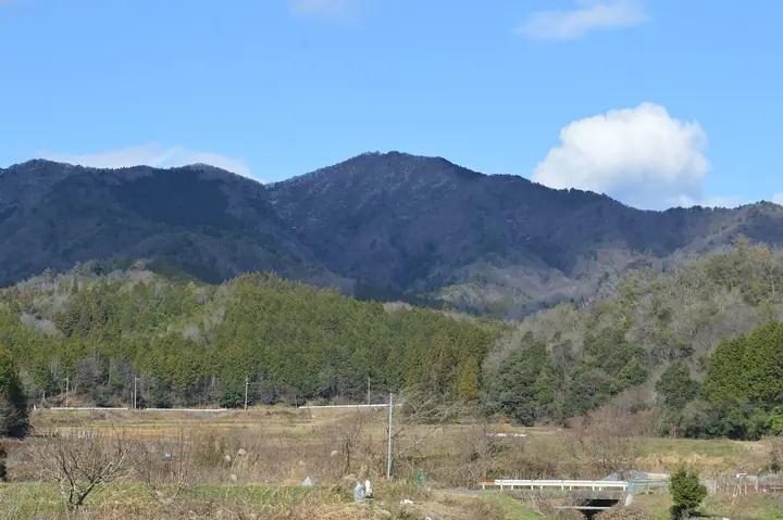
Mt. Kōryūji-ga-take (697 m) rises on the border between Kumihama Town in Kyōtango City (Kyoto Prefecture) and Tantō Town in Toyooka City (Hyōgo Prefecture), and is the highest peak of the Tango region — included in the Kyoto-Prefecture Yama-Kei guide, Furusato Hyōgo 100 and other regional lists. The trail begins at Kamigahata near the northern portal of the Tantō Tunnel, passes through beech forest, and reaches a broad summit with sweeping views of the Sea of Japan and the Tango and Tajima peninsulas. The mountain lies just inland of the San'in Coast Geopark and Tango-Amanohashidate-Ōeyama Quasi-National Park.
Mt. Kōryūji-ga-take at a glance
- Weather: The most settled day in the next 7 days is Wed, November 4: clear, gusts up to 8 m/s. Fri, Nov 6, Sat, Nov 7: strong wind (gusts up to 16 m/s).
Mt. Kōryūji-ga-take weather (hourly, 14 days)
Sunrise today 06:23, sunset 17:04
| Tue, 11/3 | Wed, 11/4 | Thu, 11/5 | Fri, 11/6 | Sat, 11/7 | Sun, 11/8 | Mon, 11/9 | Tue, 11/10 | Wed, 11/11 | Thu, 11/12 | Fri, 11/13 | Sat, 11/14 | Sun, 11/15 | Mon, 11/16 | Tue, 11/17 | |||||||||||||||||||||||||||||||||||||||||||||||||||||||||||||||||||||||
|---|---|---|---|---|---|---|---|---|---|---|---|---|---|---|---|---|---|---|---|---|---|---|---|---|---|---|---|---|---|---|---|---|---|---|---|---|---|---|---|---|---|---|---|---|---|---|---|---|---|---|---|---|---|---|---|---|---|---|---|---|---|---|---|---|---|---|---|---|---|---|---|---|---|---|---|---|---|---|---|---|---|---|---|---|---|
| Japan time | 15 | 17 | 19 | 21 | 23 | 1 | 3 | 5 | 7 | 9 | 11 | 13 | 15 | 18 | 21 | 0 | 3 | 6 | 9 | 12 | 15 | 18 | 21 | 0 | 3 | 6 | 9 | 12 | 15 | 18 | 21 | 0 | 3 | 6 | 9 | 12 | 15 | 18 | 21 | 0 | 3 | 6 | 9 | 12 | 15 | 18 | 21 | 0 | 3 | 6 | 9 | 15 | 21 | 3 | 9 | 15 | 21 | 3 | 9 | 15 | 21 | 3 | 9 | 15 | 21 | 3 | 9 | 15 | 21 | 3 | 9 | 15 | 21 | 3 | 9 | 15 | 21 | 3 | 9 | 15 | 21 | 3 | 9 | 15 | |
  | |   | |   | | | |   |  | |   | | | |   | | |   | |   | | |   | |   | | | |   | | | | | | | | | | | | |   | | | | | | | | | | | | | | | | | | | | | | | | | | | | | | | | | | | | | | | | | | ||
| Temperature | °C | 12° | 10° | 10° | 8° | 8° | 8° | 7° | 8° | 8° | 12° | 14° | 15° | 13° | 10° | 9° | 10° | 10° | 10° | 11° | 18° | 15° | 12° | 12° | 11° | 12° | 11° | 14° | 15° | 13° | 12° | 10° | 8° | 8° | 7° | 8° | 9° | 8° | 7° | 8° | 8° | 8° | 8° | 10° | 12° | 10° | 9° | 8° | 7° | 7° | 6° | 9° | 9° | 7° | 7° | 9° | 11° | 6° | 6° | 8° | 8° | 7° | 6° | 8° | 11° | 5° | 6° | 9° | 9° | 7° | 6° | 9° | 13° | 5° | 8° | 12° | 13° | 12° | 11° | 11° | 9° | 6° | 6° | 7° | 8° |
| Precipitation | mm | 0.2 | 0.3 | 0.5 | 2.1 | 0.8 | 0.4 | 1.5 | 1.2 | 3.4 | 1.3 | 0.1 | 0.1 | 0.1 | 0.1 | 0.3 | 1.1 | 0.4 | 0.6 | 0.1 | 0.1 | 1.2 | 3.8 | 1.1 | 0.5 | 1.3 | 1.0 | 2.1 | 0.6 | 0.5 | 2.1 | 3.7 | 0.2 | 7 | 6 | 2.4 | 8 | 1.8 | |||||||||||||||||||||||||||||||||||||||||||||||
| New snow | cm | ||||||||||||||||||||||||||||||||||||||||||||||||||||||||||||||||||||||||||||||||||||
| Snow depth | cm | 0 | 0 | 0 | 0 | 0 | 0 | 0 | 0 | 0 | 0 | 0 | 0 | 0 | 0 | 0 | 0 | 0 | 0 | 0 | 0 | 0 | 0 | 0 | 0 | 0 | 0 | 0 | 0 | 0 | 0 | 0 | 0 | 0 | 0 | 0 | 0 | 0 | 0 | 0 | 0 | 0 | 0 | 0 | 0 | 0 | 0 | 0 | 0 | 0 | 0 | 0 | 0 | 0 | 0 | 0 | 0 | 0 | 0 | 0 | 0 | 0 | 0 | 0 | 0 | 0 | 0 | 0 | 0 | 0 | 0 | 0 | 0 | 0 | 0 | 0 | 0 | 0 | 0 | 0 | 0 | 0 | 0 | 0 | 0 |
| Wind | m/s | 3 | 1 | 1 | 2 | 1 | 1 | 1 | 1 | 2 | 2 | 3 | 3 | 3 | 1 | 2 | 3 | 3 | 1 | 2 | 0 | 3 | 0 | 0 | 1 | 2 | 4 | 5 | 6 | 6 | 5 | 6 | 6 | 5 | 6 | 6 | 7 | 5 | 4 | 4 | 3 | 2 | 1 | 1 | 4 | 3 | 1 | 0 | 1 | 0 | 1 | 1 | 3 | 1 | 2 | 2 | 5 | 5 | 8 | 7 | 5 | 3 | 1 | 1 | 2 | 2 | 1 | 6 | 5 | 3 | 1 | 2 | 0 | 3 | 4 | 4 | 5 | 6 | 2 | 3 | 7 | 5 | 3 | 3 | 3 |
| Wind gusts | m/s | 9 | 8 | 3 | 3 | 3 | 2 | 3 | 4 | 4 | 6 | 8 | 8 | 8 | 7 | 4 | 7 | 7 | 6 | 4 | 4 | 7 | 6 | 3 | 4 | 6 | 10 | 12 | 15 | 15 | 14 | 13 | 14 | 13 | 14 | 14 | 16 | 16 | 12 | 9 | 8 | 7 | 6 | 3 | 10 | 12 | 8 | 2 | 3 | 3 | 2 | 5 | 11 | 8 | 3 | 6 | 14 | 13 | 20 | 20 | 16 | 12 | 6 | 4 | 6 | 7 | 6 | 14 | 14 | 12 | 6 | 5 | 5 | 7 | 9 | 11 | 14 | 17 | 15 | 11 | 15 | 15 | 12 | 8 | 9 |
| Wind dir. | ↓ | ↓ | ↓ | ↓ | ↓ | ↓ | ↓ | ↓ | ↓ | ↓ | ↓ | ↓ | ↓ | ↓ | ↓ | ↓ | ↓ | ↓ | ↓ | ↓ | ↓ | ↓ | ↓ | ↓ | ↓ | ↓ | ↓ | ↓ | ↓ | ↓ | ↓ | ↓ | ↓ | ↓ | ↓ | ↓ | ↓ | ↓ | ↓ | ↓ | ↓ | ↓ | ↓ | ↓ | ↓ | ↓ | ↓ | ↓ | ↓ | ↓ | ↓ | ↓ | ↓ | ↓ | ↓ | ↓ | ↓ | ↓ | ↓ | ↓ | ↓ | ↓ | ↓ | ↓ | ↓ | ↓ | ↓ | ↓ | ↓ | ↓ | ↓ | ↓ | ↓ | ↓ | ↓ | ↓ | ↓ | ↓ | ↓ | ↓ | ↓ | ↓ | ↓ | ↓ | |
Lists that include Mt. Kōryūji-ga-take
Mt. Kōryūji-ga-take facts
- Elevation
- 697 m
- Location
- Kyōtango-shi, Kyoto
35.522984, 134.971107 - Website
- www.uminokyoto.jp
- Trail Map
- tantosilk.gr.jp
- Wikipedia
- ja.wikipedia.org