
Mt. Kasagiyama
笠置山
Ena, Gifu · Elevation 1,128 m
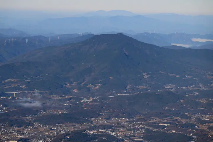
Mt. Kasagiyama is a 1,128-meter freestanding peak straddling Ena City and Nakatsugawa City in Gifu Prefecture, named — according to a Heian-era legend in which retired Emperor Kazan compared its conical, hat-like profile to Kyoto's Kasagiyama. The summit shrine Kasagi-jinja is revered locally as a rain-prayer kami, and the slopes hold a national natural-monument hitotsubatago (Chionanthus retusus) habitat, a prefecturally protected luminous-moss colony, prehistoric petroglyphs, and large volcanic boulders such as Monomi-iwa and Pyramid Rock. A trail of 30–50 minutes from the Bōkyō-no-Mori campground on the Nakanokata side and a longer route from Himekuri lead to the summit, which is included in the Gifu Hyakuzan, Tōkai-no-Hyakuzan, and Gifu Hyakushūzan lists.
Mt. Kasagiyama at a glance
- Weather: The most settled day in the next 7 days is Sun, November 8: clear, gusts up to 5 m/s.
Mt. Kasagiyama weather (hourly, 14 days)
Sunrise today 06:14, sunset 16:55
| Tue, 11/3 | Wed, 11/4 | Thu, 11/5 | Fri, 11/6 | Sat, 11/7 | Sun, 11/8 | Mon, 11/9 | Tue, 11/10 | Wed, 11/11 | Thu, 11/12 | Fri, 11/13 | Sat, 11/14 | Sun, 11/15 | Mon, 11/16 | Tue, 11/17 | |||||||||||||||||||||||||||||||||||||||||||||||||||||||||||||||||||||||
|---|---|---|---|---|---|---|---|---|---|---|---|---|---|---|---|---|---|---|---|---|---|---|---|---|---|---|---|---|---|---|---|---|---|---|---|---|---|---|---|---|---|---|---|---|---|---|---|---|---|---|---|---|---|---|---|---|---|---|---|---|---|---|---|---|---|---|---|---|---|---|---|---|---|---|---|---|---|---|---|---|---|---|---|---|---|
| Japan time | 15 | 17 | 19 | 21 | 23 | 1 | 3 | 5 | 7 | 9 | 11 | 13 | 15 | 18 | 21 | 0 | 3 | 6 | 9 | 12 | 15 | 18 | 21 | 0 | 3 | 6 | 9 | 12 | 15 | 18 | 21 | 0 | 3 | 6 | 9 | 12 | 15 | 18 | 21 | 0 | 3 | 6 | 9 | 12 | 15 | 18 | 21 | 0 | 3 | 6 | 9 | 15 | 21 | 3 | 9 | 15 | 21 | 3 | 9 | 15 | 21 | 3 | 9 | 15 | 21 | 3 | 9 | 15 | 21 | 3 | 9 | 15 | 21 | 3 | 9 | 15 | 21 | 3 | 9 | 15 | 21 | 3 | 9 | 15 | |
 |  |   | | | | | |   | | |   | |   | |   | | |   | | |  |   | | |   | |   | | | | | | | | | | | | | | | | | | | | | | | | |   | | | | | | | | |  | | | | | | | | | | | | |   |   | | | | | | | | | ||
| Temperature | °C | 15° | 10° | 6° | 4° | 3° | 2° | 1° | 1° | 2° | 12° | 15° | 16° | 14° | 11° | 10° | 8° | 9° | 9° | 10° | 14° | 14° | 10° | 9° | 8° | 8° | 9° | 12° | 16° | 15° | 9° | 7° | 6° | 4° | 2° | 8° | 10° | 9° | 4° | 1° | -1° | -2° | -4° | 6° | 11° | 12° | 5° | 6° | 5° | 5° | 5° | 9° | 13° | 4° | 0° | 9° | 11° | 5° | 1° | 5° | 8° | -1° | -5° | 8° | 10° | 1° | 1° | 8° | 10° | -1° | -2° | 9° | 11° | 4° | 6° | 11° | 11° | 9° | 9° | 12° | 14° | 4° | -1° | 7° | 10° |
| Precipitation | mm | 7 | 8 | 0.5 | 1.5 | 0.2 | 3.4 | 6 | 0.2 | 1.6 | 1.3 | 0.1 | 1.1 | 22 | 15 | 0.2 | 0.3 | ||||||||||||||||||||||||||||||||||||||||||||||||||||||||||||||||||||
| New snow | cm | ||||||||||||||||||||||||||||||||||||||||||||||||||||||||||||||||||||||||||||||||||||
| Snow depth | cm | 0 | 0 | 0 | 0 | 0 | 0 | 0 | 0 | 0 | 0 | 0 | 0 | 0 | 0 | 0 | 0 | 0 | 0 | 0 | 0 | 0 | 0 | 0 | 0 | 0 | 0 | 0 | 0 | 0 | 0 | 0 | 0 | 0 | 0 | 0 | 0 | 0 | 0 | 0 | 0 | 0 | 0 | 0 | 0 | 0 | 0 | 0 | 0 | 0 | 0 | 0 | 0 | 0 | 0 | 0 | 0 | 0 | 0 | 0 | 0 | 0 | 0 | 0 | 0 | 0 | 0 | 0 | 0 | 0 | 0 | 0 | 0 | 0 | 0 | 0 | 0 | 0 | 0 | 0 | 0 | 0 | 0 | 0 | 0 |
| Wind | m/s | 3 | 1 | 1 | 1 | 1 | 1 | 1 | 1 | 2 | 1 | 1 | 2 | 2 | 0 | 0 | 1 | 1 | 1 | 2 | 1 | 1 | 0 | 1 | 0 | 1 | 1 | 2 | 4 | 5 | 4 | 2 | 4 | 3 | 2 | 3 | 5 | 4 | 2 | 2 | 1 | 1 | 1 | 1 | 2 | 1 | 1 | 0 | 0 | 0 | 0 | 1 | 3 | 0 | 1 | 1 | 3 | 0 | 4 | 4 | 5 | 1 | 1 | 1 | 2 | 0 | 1 | 2 | 5 | 1 | 2 | 2 | 3 | 1 | 2 | 1 | 2 | 2 | 1 | 1 | 6 | 2 | 1 | 0 | 2 |
| Wind gusts | m/s | 9 | 8 | 4 | 2 | 2 | 3 | 3 | 4 | 4 | 4 | 4 | 6 | 6 | 4 | 2 | 6 | 7 | 4 | 5 | 4 | 4 | 3 | 1 | 2 | 3 | 6 | 6 | 11 | 13 | 12 | 10 | 10 | 10 | 8 | 8 | 13 | 13 | 10 | 7 | 5 | 4 | 3 | 4 | 5 | 5 | 5 | 3 | 2 | 2 | 2 | 3 | 10 | 8 | 2 | 4 | 9 | 7 | 12 | 12 | 13 | 12 | 4 | 4 | 8 | 5 | 3 | 6 | 12 | 11 | 4 | 5 | 8 | 6 | 5 | 5 | 7 | 7 | 7 | 4 | 14 | 14 | 6 | 3 | 6 |
| Wind dir. | ↓ | ↓ | ↓ | ↓ | ↓ | ↓ | ↓ | ↓ | ↓ | ↓ | ↓ | ↓ | ↓ | ↓ | ↓ | ↓ | ↓ | ↓ | ↓ | ↓ | ↓ | ↓ | ↓ | ↓ | ↓ | ↓ | ↓ | ↓ | ↓ | ↓ | ↓ | ↓ | ↓ | ↓ | ↓ | ↓ | ↓ | ↓ | ↓ | ↓ | ↓ | ↓ | ↓ | ↓ | ↓ | ↓ | ↓ | ↓ | ↓ | ↓ | ↓ | ↓ | ↓ | ↓ | ↓ | ↓ | ↓ | ↓ | ↓ | ↓ | ↓ | ↓ | ↓ | ↓ | ↓ | ↓ | ↓ | ↓ | ↓ | ↓ | ↓ | ↓ | ↓ | ↓ | ↓ | ↓ | ↓ | ↓ | ↓ | ↓ | ↓ | ↓ | ↓ | ↓ | |
Huts, campsites and lodging near Mt. Kasagiyama
Campsites
- 笠置クライミングキャンプサイト
- 望郷の森キャンプ場
Lists that include Mt. Kasagiyama
Tokai 100 Mountains · 100 Mountains of Gifu · 1000 Mountains of Japan
Mt. Kasagiyama facts
- Also known as
- 船伏山
- Elevation
- 1,128 m
- Location
- Ena, Gifu
35.510784, 137.347834 - Website
- www.kankou-ena.jp
- Trail Map
- www.kankou-ena.jp (PDF)
- Wikipedia
- ja.wikipedia.org