
Mt. Futatsumoriyama
二ツ森山
Nakatsugawa, Gifu · Elevation 1,223 m
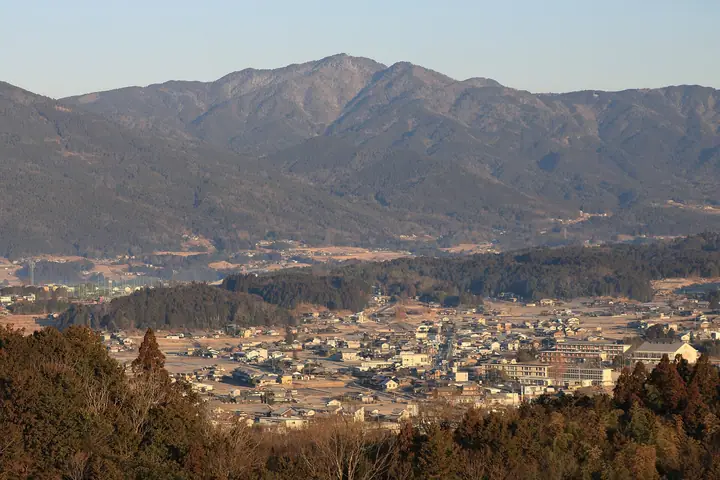
Mt. Futatsumoriyama is a 1,223.5-meter twin-summit peak straddling Nakatsugawa City and Shirakawa Town in Kamo District, Gifu Prefecture — viewed from the east, its eastern and western summits form a distinctive double crown that gives the mountain its name. Selected for the Gifu Hyakuzan by the Gifu Prefectural Alpine Federation, it also appears in the Gifu Hyakushūzan and Nihon-no-Yama 1000 lists. A Futatsumori Forest Park, developed on the eastern flank between 2001–2005, provides parking near the seventh station, and a family-friendly trail reaches the summit in 30–60 minutes; the longer ridge route from Kirigoshi Pass on the northern shoulder takes about two hours. A Gifu prefectural natural-monument Ō-Nara (large oak) stands near the summit, which offers views of the Central Alps, Southern Alps, and Mt. Ontake.
Mt. Futatsumoriyama at a glance
- Weather: The most settled day in the next 7 days is Sun, November 8: clear, gusts up to 5 m/s.
Mt. Futatsumoriyama weather (hourly, 14 days)
Sunrise today 06:13, sunset 16:55
| Tue, 11/3 | Wed, 11/4 | Thu, 11/5 | Fri, 11/6 | Sat, 11/7 | Sun, 11/8 | Mon, 11/9 | Tue, 11/10 | Wed, 11/11 | Thu, 11/12 | Fri, 11/13 | Sat, 11/14 | Sun, 11/15 | Mon, 11/16 | Tue, 11/17 | |||||||||||||||||||||||||||||||||||||||||||||||||||||||||||||||||||||||
|---|---|---|---|---|---|---|---|---|---|---|---|---|---|---|---|---|---|---|---|---|---|---|---|---|---|---|---|---|---|---|---|---|---|---|---|---|---|---|---|---|---|---|---|---|---|---|---|---|---|---|---|---|---|---|---|---|---|---|---|---|---|---|---|---|---|---|---|---|---|---|---|---|---|---|---|---|---|---|---|---|---|---|---|---|---|
| Japan time | 15 | 17 | 19 | 21 | 23 | 1 | 3 | 5 | 7 | 9 | 11 | 13 | 15 | 18 | 21 | 0 | 3 | 6 | 9 | 12 | 15 | 18 | 21 | 0 | 3 | 6 | 9 | 12 | 15 | 18 | 21 | 0 | 3 | 6 | 9 | 12 | 15 | 18 | 21 | 0 | 3 | 6 | 9 | 12 | 15 | 18 | 21 | 0 | 3 | 6 | 9 | 15 | 21 | 3 | 9 | 15 | 21 | 3 | 9 | 15 | 21 | 3 | 9 | 15 | 21 | 3 | 9 | 15 | 21 | 3 | 9 | 15 | 21 | 3 | 9 | 15 | 21 | 3 | 9 | 15 | 21 | 3 | 9 | 15 | |
 |  |   | | | | | |   | | |   | |   | |   | | |   | |   | |   | | |   | | | |  | | | | | | | | | | | | | | | | | | | | | | |   | | | | |   | | | |  | | | | | | | | | | | | |   |   | | | | | | | | | ||
| Temperature | °C | 13° | 8° | 5° | 3° | 1° | 0° | 0° | 0° | 0° | 10° | 14° | 14° | 12° | 9° | 7° | 7° | 7° | 7° | 9° | 13° | 12° | 9° | 8° | 6° | 6° | 7° | 10° | 14° | 13° | 7° | 4° | 3° | 2° | 0° | 6° | 8° | 7° | 1° | -1° | -3° | -4° | -5° | 4° | 9° | 9° | 4° | 4° | 3° | 3° | 3° | 7° | 11° | 2° | -2° | 7° | 9° | 3° | 0° | 3° | 6° | -3° | -6° | 6° | 8° | 0° | -1° | 6° | 9° | -3° | -3° | 7° | 9° | 1° | 3° | 9° | 10° | 6° | 7° | 10° | 13° | 2° | -2° | 6° | 8° |
| Precipitation | mm | 8 | 8 | 0.1 | 1.2 | 0.1 | 1.4 | 4.8 | 0.4 | 1.7 | 1.7 | 0.6 | 22 | 14 | 0.2 | 0.9 | |||||||||||||||||||||||||||||||||||||||||||||||||||||||||||||||||||||
| New snow | cm | ||||||||||||||||||||||||||||||||||||||||||||||||||||||||||||||||||||||||||||||||||||
| Snow depth | cm | 0 | 0 | 0 | 0 | 0 | 0 | 0 | 0 | 0 | 0 | 0 | 0 | 0 | 0 | 0 | 0 | 0 | 0 | 0 | 0 | 0 | 0 | 0 | 0 | 0 | 0 | 0 | 0 | 0 | 0 | 0 | 0 | 0 | 0 | 0 | 0 | 0 | 0 | 0 | 0 | 0 | 0 | 0 | 0 | 0 | 0 | 0 | 0 | 0 | 0 | 0 | 0 | 0 | 0 | 0 | 0 | 0 | 0 | 0 | 0 | 0 | 0 | 0 | 0 | 0 | 0 | 0 | 0 | 0 | 0 | 0 | 0 | 0 | 0 | 0 | 0 | 0 | 0 | 0 | 0 | 0 | 0 | 0 | 0 |
| Wind | m/s | 2 | 1 | 0 | 1 | 1 | 1 | 1 | 1 | 1 | 1 | 1 | 2 | 1 | 0 | 1 | 1 | 1 | 2 | 2 | 1 | 1 | 0 | 1 | 1 | 1 | 0 | 1 | 4 | 4 | 2 | 0 | 1 | 1 | 1 | 2 | 5 | 4 | 1 | 0 | 0 | 1 | 1 | 1 | 1 | 1 | 0 | 0 | 0 | 0 | 1 | 1 | 3 | 0 | 1 | 0 | 3 | 0 | 3 | 1 | 3 | 1 | 1 | 0 | 2 | 0 | 1 | 1 | 3 | 1 | 2 | 2 | 2 | 1 | 2 | 2 | 1 | 2 | 1 | 0 | 4 | 1 | 0 | 1 | 1 |
| Wind gusts | m/s | 6 | 6 | 3 | 2 | 3 | 3 | 4 | 4 | 4 | 4 | 4 | 6 | 6 | 4 | 3 | 6 | 7 | 4 | 5 | 5 | 3 | 3 | 1 | 2 | 3 | 6 | 4 | 10 | 12 | 11 | 7 | 6 | 6 | 5 | 6 | 13 | 12 | 10 | 5 | 3 | 3 | 2 | 4 | 5 | 5 | 4 | 2 | 2 | 2 | 2 | 3 | 10 | 8 | 3 | 4 | 9 | 7 | 12 | 9 | 10 | 9 | 4 | 4 | 8 | 5 | 3 | 4 | 9 | 8 | 5 | 5 | 8 | 6 | 5 | 5 | 6 | 7 | 7 | 3 | 11 | 11 | 3 | 3 | 6 |
| Wind dir. | ↓ | ↓ | ↓ | ↓ | ↓ | ↓ | ↓ | ↓ | ↓ | ↓ | ↓ | ↓ | ↓ | ↓ | ↓ | ↓ | ↓ | ↓ | ↓ | ↓ | ↓ | ↓ | ↓ | ↓ | ↓ | ↓ | ↓ | ↓ | ↓ | ↓ | ↓ | ↓ | ↓ | ↓ | ↓ | ↓ | ↓ | ↓ | ↓ | ↓ | ↓ | ↓ | ↓ | ↓ | ↓ | ↓ | ↓ | ↓ | ↓ | ↓ | ↓ | ↓ | ↓ | ↓ | ↓ | ↓ | ↓ | ↓ | ↓ | ↓ | ↓ | ↓ | ↓ | ↓ | ↓ | ↓ | ↓ | ↓ | ↓ | ↓ | ↓ | ↓ | ↓ | ↓ | ↓ | ↓ | ↓ | ↓ | ↓ | ↓ | ↓ | ↓ | ↓ | ↓ | |
Lists that include Mt. Futatsumoriyama
100 Mountains of Gifu · Elevations of 1003 Mountains of Japan · 1000 Mountains of Japan
Mt. Futatsumoriyama facts
- Elevation
- 1,223 m
- Location
- Nakatsugawa, Gifu
35.572004, 137.400438 - Website
- www.city.nakatsugawa.lg.jp
- Wikipedia
- ja.wikipedia.org