
Mt. Izu
伊豆山
Daisen, Akita · Elevation 208 m
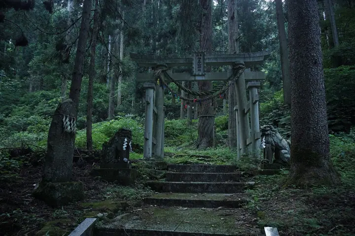
Mt. Izu is a 208 m low peak in the Kamioka district of Daisen City, Akita Prefecture, rising along the left bank of the Ōmono River. Its summit holds the main shrine of Izusan-jinja, founded by tradition by Sakanoue no Tamuramaro during his early-Heian pacification campaign, reached in about 30 minutes from the trailhead along the shrine approach. The peak is commonly traversed together with neighboring Mt. Jingūji and Mt. Taihei, and on 17 February each year the "Bonten Crossing the River" festival — a Daisen City-designated cultural property — carries sacred bonten poles by boat across the Ōmono River up to the main shrine. The mountain is featured in the Akita Prefecture Mountain Guide.
Mt. Izu at a glance
- Weather: The most settled day in the next 7 days is Wed, November 4: clear, gusts up to 7 m/s. Sat, Nov 7, Sun, Nov 8: strong wind (gusts up to 21 m/s).
Mt. Izu weather (hourly, 14 days)
Sunrise today 06:08, sunset 16:36
| Tue, 11/3 | Wed, 11/4 | Thu, 11/5 | Fri, 11/6 | Sat, 11/7 | Sun, 11/8 | Mon, 11/9 | Tue, 11/10 | Wed, 11/11 | Thu, 11/12 | Fri, 11/13 | Sat, 11/14 | Sun, 11/15 | Mon, 11/16 | Tue, 11/17 | |||||||||||||||||||||||||||||||||||||||||||||||||||||||||||||||||||||||
|---|---|---|---|---|---|---|---|---|---|---|---|---|---|---|---|---|---|---|---|---|---|---|---|---|---|---|---|---|---|---|---|---|---|---|---|---|---|---|---|---|---|---|---|---|---|---|---|---|---|---|---|---|---|---|---|---|---|---|---|---|---|---|---|---|---|---|---|---|---|---|---|---|---|---|---|---|---|---|---|---|---|---|---|---|---|
| Japan time | 15 | 17 | 19 | 21 | 23 | 1 | 3 | 5 | 7 | 9 | 11 | 13 | 15 | 18 | 21 | 0 | 3 | 6 | 9 | 12 | 15 | 18 | 21 | 0 | 3 | 6 | 9 | 12 | 15 | 18 | 21 | 0 | 3 | 6 | 9 | 12 | 15 | 18 | 21 | 0 | 3 | 6 | 9 | 12 | 15 | 18 | 21 | 0 | 3 | 6 | 9 | 15 | 21 | 3 | 9 | 15 | 21 | 3 | 9 | 15 | 21 | 3 | 9 | 15 | 21 | 3 | 9 | 15 | 21 | 3 | 9 | 15 | 21 | 3 | 9 | 15 | 21 | 3 | 9 | 15 | 21 | 3 | 9 | 15 | |
 |  | |   |   |   |   | |   |   | | | | | | | | |   | |   | |   | | | | | | | | | | | |   | |   |   | | | | | |   | |   | | | | | | | | | | | | | |   | | | | | | | | | | | | |  | | | | | | | | | | | | ||
| Temperature | °C | 11° | 8° | 6° | 6° | 5° | 6° | 5° | 5° | 6° | 10° | 14° | 15° | 14° | 8° | 5° | 6° | 8° | 9° | 10° | 12° | 12° | 12° | 10° | 10° | 10° | 10° | 13° | 15° | 13° | 10° | 7° | 5° | 5° | 4° | 5° | 7° | 5° | 5° | 5° | 5° | 4° | 5° | 7° | 7° | 7° | 6° | 5° | 4° | 4° | 3° | 6° | 7° | 3° | 3° | 6° | 10° | 5° | 6° | 7° | 8° | 2° | 3° | 6° | 9° | 6° | 6° | 6° | 7° | 4° | 0° | 6° | 10° | 2° | -1° | 7° | 13° | 8° | 8° | 10° | 7° | 3° | 4° | 6° | 8° |
| Precipitation | mm | 0.2 | 0.4 | 0.7 | 0.1 | 0.9 | 3.4 | 3.4 | 0.4 | 1.5 | 1.5 | 0.8 | 0.4 | 3.4 | 2.4 | 1.3 | 1.4 | 3.2 | 2.4 | 2.4 | 2.3 | 1.7 | 1.1 | 1.2 | 0.8 | 0.3 | 0.1 | 0.6 | 0.6 | 0.1 | 0.1 | 3.9 | 9 | 2.2 | 0.3 | 0.1 | 10 | 0.1 | 4.9 | 3.0 | 2.1 | 2.7 | |||||||||||||||||||||||||||||||||||||||||||
| New snow | cm | 0.1 | <.1 | <.1 | <.1 | <.1 | <.1 | <.1 | |||||||||||||||||||||||||||||||||||||||||||||||||||||||||||||||||||||||||||||
| Snow depth | cm | 0 | 0 | 0 | 0 | 0 | 0 | 0 | 0 | 0 | 0 | 0 | 0 | 0 | 0 | 0 | 0 | 0 | 0 | 0 | 0 | 0 | 0 | 0 | 0 | 0 | 0 | 0 | 0 | 0 | 0 | 0 | 0 | 0 | 0 | 0 | 0 | 0 | 0 | 0 | 0 | 0 | 0 | 0 | 0 | 0 | 0 | 0 | 0 | 0 | 0 | 0 | 0 | 0 | 0 | 0 | 0 | 0 | 0 | 0 | 0 | 0 | 0 | 0 | 0 | 0 | 0 | 0 | 0 | 0 | 0 | 0 | 0 | 0 | 0 | 0 | 0 | 0 | 0 | 0 | 0 | 0 | 0 | 0 | 0 |
| Wind | m/s | 5 | 3 | 2 | 0 | 2 | 1 | 1 | 2 | 2 | 1 | 2 | 3 | 2 | 1 | 2 | 3 | 3 | 2 | 2 | 1 | 0 | 0 | 1 | 1 | 0 | 1 | 1 | 5 | 6 | 5 | 6 | 4 | 4 | 4 | 6 | 9 | 7 | 6 | 6 | 6 | 5 | 5 | 7 | 9 | 8 | 4 | 2 | 2 | 1 | 1 | 0 | 3 | 1 | 1 | 2 | 4 | 3 | 3 | 2 | 4 | 1 | 1 | 1 | 3 | 2 | 2 | 4 | 6 | 2 | 1 | 1 | 3 | 1 | 1 | 0 | 0 | 2 | 1 | 0 | 5 | 4 | 2 | 0 | 3 |
| Wind gusts | m/s | 12 | 11 | 5 | 3 | 3 | 4 | 3 | 3 | 4 | 4 | 5 | 7 | 7 | 4 | 3 | 5 | 6 | 6 | 5 | 4 | 2 | 1 | 2 | 2 | 2 | 2 | 4 | 12 | 14 | 12 | 12 | 11 | 8 | 11 | 15 | 21 | 20 | 16 | 14 | 13 | 13 | 11 | 15 | 19 | 19 | 17 | 8 | 5 | 3 | 3 | 3 | 10 | 7 | 3 | 5 | 10 | 13 | 9 | 7 | 11 | 8 | 3 | 4 | 8 | 6 | 4 | 9 | 13 | 12 | 4 | 4 | 7 | 6 | 2 | 3 | 4 | 4 | 5 | 3 | 13 | 13 | 10 | 5 | 7 |
| Wind dir. | ↓ | ↓ | ↓ | ↓ | ↓ | ↓ | ↓ | ↓ | ↓ | ↓ | ↓ | ↓ | ↓ | ↓ | ↓ | ↓ | ↓ | ↓ | ↓ | ↓ | ↓ | ↓ | ↓ | ↓ | ↓ | ↓ | ↓ | ↓ | ↓ | ↓ | ↓ | ↓ | ↓ | ↓ | ↓ | ↓ | ↓ | ↓ | ↓ | ↓ | ↓ | ↓ | ↓ | ↓ | ↓ | ↓ | ↓ | ↓ | ↓ | ↓ | ↓ | ↓ | ↓ | ↓ | ↓ | ↓ | ↓ | ↓ | ↓ | ↓ | ↓ | ↓ | ↓ | ↓ | ↓ | ↓ | ↓ | ↓ | ↓ | ↓ | ↓ | ↓ | ↓ | ↓ | ↓ | ↓ | ↓ | ↓ | ↓ | ↓ | ↓ | ↓ | ↓ | ↓ | |
Huts, campsites and lodging near Mt. Izu
Lodging
- スパ姫神
- 大曲エンパイヤホテル
- かみおか温泉 嶽の湯
- Tabist
- 月岡ホテル
Mt. Izu facts
- Elevation
- 208 m
- Location
- Daisen, Akita
39.477848, 140.441950 - Website
- www.izu.or.jp
- Access Information
- www.izu.or.jp
- Wikipedia
- ja.wikipedia.org