
Mount Tokachi-Poroshiri
十勝幌尻岳
Obihiro, Hokkaido · Elevation 1,846 m
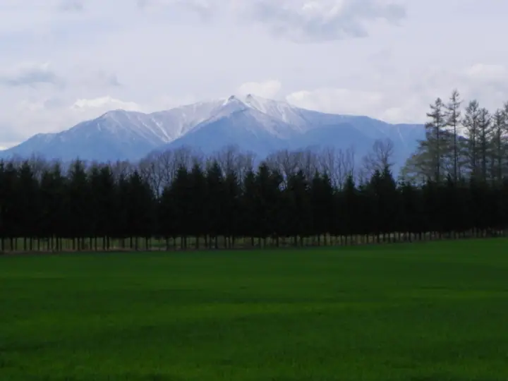
Mount Tokachi-Poroshiri is a 1,846 m peak on the border between Obihiro City and Nakasatsunai Village in Hokkaido, the highest summit of a side ridge that extends east from the main northern Hidaka spine. Its name comes from the Ainu 'poro-shir' ('big mountain'), prefixed with 'Tokachi' to distinguish it from the higher Mount Poroshiri, and climbers affectionately abbreviate it 'Kachiporo'. The summit commands wide views of the Tokachi plain and the Hidaka main ridge. A maintained trail runs up from the Opirinep River forest road. The mountain lies within Hidaka-Sanmyaku-Erimo-Tokachi National Park designated in 2024 and is counted on the 100 Famous Mountains of Hokkaido.
Mount Tokachi-Poroshiri at a glance
- Weather: The most settled day in the next 7 days is Thu, November 5: cloudy, gusts up to 9 m/s. Wed, Nov 4, Sat, Nov 7, Sun, Nov 8: strong wind (gusts up to 25 m/s).
Mount Tokachi-Poroshiri weather (hourly, 14 days)
Sunrise today 06:04, sunset 16:20
| Tue, 11/3 | Wed, 11/4 | Thu, 11/5 | Fri, 11/6 | Sat, 11/7 | Sun, 11/8 | Mon, 11/9 | Tue, 11/10 | Wed, 11/11 | Thu, 11/12 | Fri, 11/13 | Sat, 11/14 | Sun, 11/15 | Mon, 11/16 | Tue, 11/17 | |||||||||||||||||||||||||||||||||||||||||||||||||||||||||||||||||||||||
|---|---|---|---|---|---|---|---|---|---|---|---|---|---|---|---|---|---|---|---|---|---|---|---|---|---|---|---|---|---|---|---|---|---|---|---|---|---|---|---|---|---|---|---|---|---|---|---|---|---|---|---|---|---|---|---|---|---|---|---|---|---|---|---|---|---|---|---|---|---|---|---|---|---|---|---|---|---|---|---|---|---|---|---|---|---|
| Japan time | 15 | 17 | 19 | 21 | 23 | 1 | 3 | 5 | 7 | 9 | 11 | 13 | 15 | 18 | 21 | 0 | 3 | 6 | 9 | 12 | 15 | 18 | 21 | 0 | 3 | 6 | 9 | 12 | 15 | 18 | 21 | 0 | 3 | 6 | 9 | 12 | 15 | 18 | 21 | 0 | 3 | 6 | 9 | 12 | 15 | 18 | 21 | 0 | 3 | 6 | 9 | 15 | 21 | 3 | 9 | 15 | 21 | 3 | 9 | 15 | 21 | 3 | 9 | 15 | 21 | 3 | 9 | 15 | 21 | 3 | 9 | 15 | 21 | 3 | 9 | 15 | 21 | 3 | 9 | 15 | 21 | 3 | 9 | 15 | |
  |  |   |   | |   | | |   |   |   |  | |  | | | |   | |   | |   | | | | | | | | | | | | |   | | | | | | | | | | | | | | | | | | | | | | | | | | | | | |   | | | | |  | | | | | | | |   | |   | | | | | ||
| Temperature | °C | -6° | -9° | -10° | -10° | -10° | -9° | -7° | -6° | -7° | -6° | -5° | -3° | -4° | -10° | -10° | -9° | -9° | -6° | 0° | 0° | 0° | -1° | -1° | -1° | -1° | -1° | 0° | 3° | 1° | -2° | -6° | -8° | -11° | -11° | -10° | -9° | -10° | -11° | -11° | -11° | -12° | -12° | -11° | -10° | -10° | -11° | -11° | -12° | -13° | -13° | -10° | -10° | -14° | -14° | -9° | -8° | -11° | -11° | -10° | -7° | -13° | -14° | -8° | -7° | -14° | -13° | -12° | -11° | -11° | -14° | -6° | -5° | -12° | -13° | -3° | -3° | -4° | -5° | -2° | -5° | -11° | -12° | -8° | -6° |
| Precipitation | mm | 0.1 | 0.2 | 3.2 | 0.9 | 0.6 | 0.3 | 0.4 | 5 | 2.5 | 1.6 | 1.9 | 9 | 1.1 | 0.4 | 0.8 | 0.3 | 0.1 | 0.2 | 0.1 | 0.5 | 0.7 | 0.2 | 0.4 | 0.3 | 0.2 | 0.4 | 0.4 | 0.2 | 3.3 | 3.6 | 1.0 | 0.5 | 0.2 | 0.7 | 4.7 | 1.1 | 1.0 | 1.3 | ||||||||||||||||||||||||||||||||||||||||||||||
| New snow | cm | <.1 | 0.2 | 3.1 | 0.9 | 0.3 | 0.1 | 0.2 | <.1 | 0.5 | 0.6 | <.1 | <.1 | 0.2 | 0.4 | 0.3 | 0.2 | 0.4 | 0.4 | 0.2 | <.1 | <.1 | 3.3 | 3.6 | 1.0 | <.1 | 0.5 | <.1 | <.1 | <.1 | <.1 | <.1 | <.1 | <.1 | 0.2 | <.1 | |||||||||||||||||||||||||||||||||||||||||||||||||
| Snow depth | cm | <1 | <1 | <1 | <1 | <1 | <1 | 4 | 4 | 4 | 4 | 4 | 4 | 3 | 3 | 3 | 3 | 3 | 3 | 3 | 2 | 2 | 2 | <1 | <1 | <1 | <1 | <1 | <1 | <1 | 0 | 0 | 0 | 0 | <1 | <1 | <1 | <1 | <1 | 1 | 1 | 2 | 2 | 2 | 2 | 2 | 3 | 2 | 2 | 2 | 2 | 2 | 2 | 2 | 2 | 2 | 2 | 2 | 5 | 8 | 8 | 8 | 7 | 7 | 7 | 7 | 7 | 7 | 6 | 6 | 6 | 6 | 6 | 6 | 6 | 6 | 4 | 4 | 4 | 4 | 3 | 3 | 3 | 3 | 3 |
| Wind | m/s | 4 | 3 | 3 | 4 | 3 | 3 | 4 | 4 | 5 | 5 | 5 | 2 | 1 | 3 | 3 | 3 | 3 | 3 | 2 | 1 | 1 | 1 | 0 | 1 | 1 | 1 | 1 | 3 | 4 | 9 | 10 | 9 | 9 | 6 | 7 | 8 | 9 | 11 | 10 | 8 | 8 | 8 | 9 | 7 | 7 | 7 | 6 | 4 | 4 | 3 | 3 | 3 | 3 | 2 | 1 | 2 | 0 | 3 | 2 | 0 | 1 | 1 | 2 | 2 | 2 | 2 | 3 | 3 | 2 | 2 | 0 | 0 | 1 | 2 | 2 | 3 | 3 | 2 | 1 | 0 | 2 | 2 | 1 | 0 |
| Wind gusts | m/s | 14 | 14 | 12 | 12 | 13 | 13 | 14 | 14 | 18 | 16 | 16 | 15 | 10 | 9 | 9 | 11 | 10 | 10 | 9 | 9 | 7 | 6 | 4 | 4 | 4 | 5 | 6 | 12 | 13 | 25 | 27 | 29 | 28 | 26 | 21 | 24 | 25 | 31 | 30 | 28 | 24 | 26 | 25 | 25 | 22 | 22 | 20 | 18 | 14 | 12 | 10 | 13 | 11 | 9 | 8 | 7 | 4 | 8 | 7 | 6 | 5 | 6 | 8 | 10 | 10 | 10 | 12 | 12 | 11 | 10 | 8 | 5 | 6 | 7 | 10 | 10 | 11 | 10 | 7 | 6 | 9 | 8 | 8 | 6 |
| Wind dir. | ↓ | ↓ | ↓ | ↓ | ↓ | ↓ | ↓ | ↓ | ↓ | ↓ | ↓ | ↓ | ↓ | ↓ | ↓ | ↓ | ↓ | ↓ | ↓ | ↓ | ↓ | ↓ | ↓ | ↓ | ↓ | ↓ | ↓ | ↓ | ↓ | ↓ | ↓ | ↓ | ↓ | ↓ | ↓ | ↓ | ↓ | ↓ | ↓ | ↓ | ↓ | ↓ | ↓ | ↓ | ↓ | ↓ | ↓ | ↓ | ↓ | ↓ | ↓ | ↓ | ↓ | ↓ | ↓ | ↓ | ↓ | ↓ | ↓ | ↓ | ↓ | ↓ | ↓ | ↓ | ↓ | ↓ | ↓ | ↓ | ↓ | ↓ | ↓ | ↓ | ↓ | ↓ | ↓ | ↓ | ↓ | ↓ | ↓ | ↓ | ↓ | ↓ | ↓ | ↓ | |
Lists that include Mount Tokachi-Poroshiri
Hokkaido 100 Famous Mountains · Elevations of 1003 Mountains of Japan · 1000 Mountains of Japan
Mount Tokachi-Poroshiri facts
- Also known as
- カチポロ
- Elevation
- 1,846 m
- Location
- Obihiro, Hokkaido
42.695463, 142.859382 - National Park
- 日高山脈襟裳十勝国立公園
- Website
- hidakasanmyaku-sangakucenter.jp
- Access Information
- www.rinya.maff.go.jp
- Wikipedia
- ja.wikipedia.org