
Mount Kamuiekuuchikaushi
カムイエクウチカウシ山
Shinhidaka, Hokkaido / Nakasatsunai, Hokkaido · Elevation 1,979 m
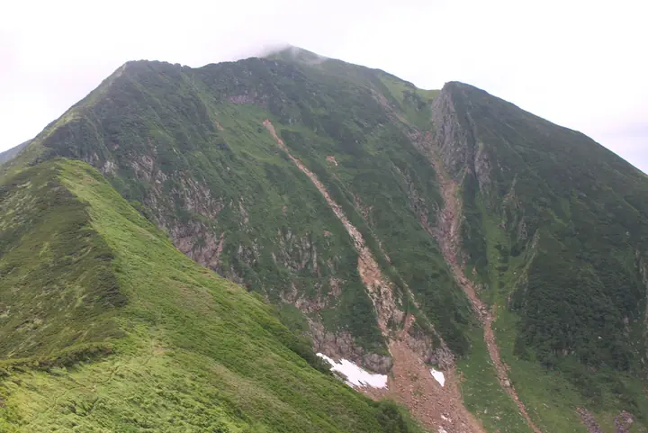
Mount Kamuiekuuchikaushi is a 1,979 m peak on the boundary between Shinhidaka Town and Nakasatsunai Village in Hokkaidō, the second-highest summit of the Hidaka Mountains after Mount Poroshiri. Listed in the Nihon Nihyaku Meizan, the Ittō-Sankakuten Hyakumeizan, and the Hokkaidō Hyakumeizan, it lies within the Hidaka-Erimo-Tokachi National Park established in 2024. Its Ainu name means "the mountain down which the bear-god tumbles," and climbers commonly abbreviate it as Kamueku. There is no maintained trail; the standard line ascends the Hachi-no-sawa from the Nanano-sawa junction in Nakasatsunai, traverses the Pyōtan Falls, and tackles the Hachi-no-sawa cirque to the main ridge. Repeated stream crossings, steep climbs, and brown-bear habitat make it one of the most demanding of the Nihyaku Meizan; the mountain is also remembered for the fatal Fukuoka University Wandervogel bear attack of 1970.
Mount Kamuiekuuchikaushi at a glance
- Weather: The most settled day in the next 7 days is Thu, November 5: cloudy, gusts up to 11 m/s. Wed, Nov 4, Fri, Nov 6, Sat, Nov 7, Sun, Nov 8: strong wind (gusts up to 25 m/s).
Mount Kamuiekuuchikaushi weather (hourly, 14 days)
Sunrise today 06:04, sunset 16:21
| Tue, 11/3 | Wed, 11/4 | Thu, 11/5 | Fri, 11/6 | Sat, 11/7 | Sun, 11/8 | Mon, 11/9 | Tue, 11/10 | Wed, 11/11 | Thu, 11/12 | Fri, 11/13 | Sat, 11/14 | Sun, 11/15 | Mon, 11/16 | Tue, 11/17 | |||||||||||||||||||||||||||||||||||||||||||||||||||||||||||||||||||||||
|---|---|---|---|---|---|---|---|---|---|---|---|---|---|---|---|---|---|---|---|---|---|---|---|---|---|---|---|---|---|---|---|---|---|---|---|---|---|---|---|---|---|---|---|---|---|---|---|---|---|---|---|---|---|---|---|---|---|---|---|---|---|---|---|---|---|---|---|---|---|---|---|---|---|---|---|---|---|---|---|---|---|---|---|---|---|
| Japan time | 15 | 17 | 19 | 21 | 23 | 1 | 3 | 5 | 7 | 9 | 11 | 13 | 15 | 18 | 21 | 0 | 3 | 6 | 9 | 12 | 15 | 18 | 21 | 0 | 3 | 6 | 9 | 12 | 15 | 18 | 21 | 0 | 3 | 6 | 9 | 12 | 15 | 18 | 21 | 0 | 3 | 6 | 9 | 12 | 15 | 18 | 21 | 0 | 3 | 6 | 9 | 15 | 21 | 3 | 9 | 15 | 21 | 3 | 9 | 15 | 21 | 3 | 9 | 15 | 21 | 3 | 9 | 15 | 21 | 3 | 9 | 15 | 21 | 3 | 9 | 15 | 21 | 3 | 9 | 15 | 21 | 3 | 9 | 15 | |
  |   | |   | |   | | |   |   |   |  | |  | | | |   | |   | |   | | | | | | | | | | | | | | | | | | | | | | | | | | | | | | | | | | | | | | | | | | |   | | | | |  | | | | | | |   | |   | | | | | | ||
| Temperature | °C | -7° | -9° | -11° | -10° | -11° | -9° | -7° | -7° | -8° | -7° | -6° | -4° | -5° | -10° | -9° | -9° | -8° | -6° | -1° | 0° | 0° | -1° | 0° | -1° | -1° | -1° | 1° | 2° | 0° | -3° | -6° | -9° | -11° | -12° | -11° | -10° | -11° | -12° | -12° | -12° | -12° | -13° | -12° | -11° | -11° | -12° | -12° | -13° | -14° | -13° | -11° | -11° | -15° | -14° | -10° | -8° | -11° | -11° | -10° | -7° | -12° | -14° | -9° | -7° | -13° | -13° | -13° | -12° | -11° | -15° | -7° | -6° | -11° | -11° | -3° | -3° | -3° | -4° | -2° | -5° | -11° | -12° | -8° | -7° |
| Precipitation | mm | 0.1 | 0.4 | 3.5 | 0.9 | 0.4 | 0.2 | 0.2 | 4.1 | 2.4 | 1.2 | 1.7 | 8 | 1.6 | 0.6 | 1.6 | 0.3 | 0.3 | 0.2 | 0.1 | 1.0 | 1.0 | 0.1 | 0.3 | 0.5 | 0.3 | 0.2 | 0.6 | 0.4 | 0.3 | 3.2 | 3.6 | 0.9 | 0.2 | 1.0 | 0.2 | 0.2 | 0.1 | 0.3 | 0.9 | 7 | 1.4 | 1.4 | 1.0 | |||||||||||||||||||||||||||||||||||||||||
| New snow | cm | 0.1 | 0.4 | 3.5 | 0.9 | <.1 | <.1 | 0.3 | 0.3 | 0.2 | 0.1 | 1.0 | 1.0 | 0.1 | 0.1 | 0.3 | 0.4 | 0.3 | 0.2 | 0.6 | 0.4 | 0.3 | <.1 | <.1 | <.1 | <.1 | 3.2 | 3.6 | 0.9 | 0.2 | 1.0 | 0.2 | <.1 | 0.2 | 0.1 | 0.1 | <.1 | 0.2 | <.1 | 0.6 | <.1 | <.1 | |||||||||||||||||||||||||||||||||||||||||||
| Snow depth | cm | 1 | 1 | 1 | 1 | 1 | 1 | 4 | 5 | 5 | 5 | 5 | 4 | 4 | 4 | 4 | 4 | 4 | 4 | 4 | 3 | 2 | 2 | 2 | 2 | 2 | 1 | <1 | <1 | <1 | 0 | 0 | <1 | <1 | <1 | <1 | 2 | 2 | 2 | 2 | 2 | 3 | 3 | 3 | 3 | 3 | 4 | 3 | 3 | 3 | 3 | 3 | 3 | 3 | 3 | 3 | 3 | 3 | 6 | 9 | 9 | 9 | 8 | 8 | 9 | 9 | 9 | 8 | 8 | 8 | 8 | 8 | 8 | 8 | 7 | 7 | 6 | 5 | 6 | 5 | 5 | 5 | 5 | 5 | 5 |
| Wind | m/s | 5 | 3 | 3 | 4 | 3 | 4 | 4 | 5 | 6 | 5 | 4 | 3 | 2 | 1 | 2 | 2 | 2 | 1 | 2 | 2 | 1 | 1 | 1 | 0 | 1 | 1 | 2 | 4 | 4 | 8 | 8 | 9 | 9 | 6 | 7 | 8 | 8 | 8 | 8 | 7 | 8 | 7 | 8 | 7 | 7 | 6 | 5 | 5 | 3 | 2 | 3 | 4 | 2 | 2 | 1 | 1 | 1 | 4 | 2 | 0 | 1 | 1 | 3 | 3 | 2 | 3 | 5 | 4 | 2 | 2 | 1 | 1 | 1 | 2 | 2 | 2 | 3 | 1 | 1 | 2 | 3 | 3 | 2 | 1 |
| Wind gusts | m/s | 16 | 15 | 13 | 13 | 13 | 13 | 16 | 16 | 19 | 18 | 17 | 16 | 13 | 9 | 8 | 9 | 9 | 9 | 10 | 11 | 10 | 7 | 5 | 5 | 5 | 6 | 8 | 13 | 15 | 23 | 25 | 27 | 27 | 26 | 22 | 24 | 25 | 26 | 25 | 25 | 24 | 24 | 24 | 24 | 23 | 22 | 19 | 17 | 15 | 12 | 11 | 14 | 12 | 9 | 8 | 7 | 5 | 11 | 10 | 8 | 5 | 6 | 9 | 11 | 12 | 11 | 15 | 15 | 14 | 11 | 10 | 7 | 7 | 7 | 10 | 11 | 11 | 10 | 6 | 8 | 11 | 12 | 12 | 8 |
| Wind dir. | ↓ | ↓ | ↓ | ↓ | ↓ | ↓ | ↓ | ↓ | ↓ | ↓ | ↓ | ↓ | ↓ | ↓ | ↓ | ↓ | ↓ | ↓ | ↓ | ↓ | ↓ | ↓ | ↓ | ↓ | ↓ | ↓ | ↓ | ↓ | ↓ | ↓ | ↓ | ↓ | ↓ | ↓ | ↓ | ↓ | ↓ | ↓ | ↓ | ↓ | ↓ | ↓ | ↓ | ↓ | ↓ | ↓ | ↓ | ↓ | ↓ | ↓ | ↓ | ↓ | ↓ | ↓ | ↓ | ↓ | ↓ | ↓ | ↓ | ↓ | ↓ | ↓ | ↓ | ↓ | ↓ | ↓ | ↓ | ↓ | ↓ | ↓ | ↓ | ↓ | ↓ | ↓ | ↓ | ↓ | ↓ | ↓ | ↓ | ↓ | ↓ | ↓ | ↓ | ↓ | |
Lists that include Mount Kamuiekuuchikaushi
Japan 200 Famous Mountains · Japan's 300 Famous Mountains · 100 Famous Mountains with First-order Triangulation Points · Hokkaido 100 Famous Mountains · Elevations of 1003 Mountains of Japan · 1000 Mountains of Japan
Mount Kamuiekuuchikaushi facts
- Also known as
- カムエク
- Elevation
- 1,979 m
- Location
- Shinhidaka, Hokkaido / Nakasatsunai, Hokkaido
42.625118, 142.766401 - National Park
- 日高山脈襟裳十勝国立公園
- Website
- hidakasanmyaku-sangakucenter.jp
- Wikipedia
- en.wikipedia.org
Mountains near Mount Kamuiekuuchikaushi
- Mount Tokachi-Poroshiri 1,846.1 m
- Mount Koikakushusatsunai 1,721 m
- Mount Yaoromappu 1,794 m
- Peak 1839 1,842 m
- Niikappufuji 1,667 m
- Mount Idonnappu 1,752 m
- Piramiddoho 1,850 m
- Mount Esaomantottabetsu 1,902 m
- Mount Satsunai 1,896 m
- Kamuidake 1,755.8 m
- Mount Piratokomi 1,587.5 m
- Mount Namewakka 1,799.1 m