
Mount Teshio
天塩岳
Takinoue, Hokkaido · Elevation 1,557 m
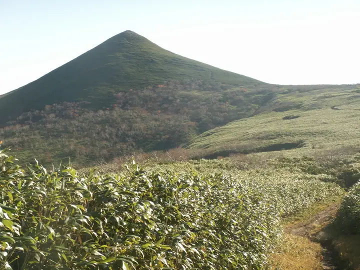
Mount Teshio is a 1,557.6 m peak straddling Shibetsu City and Takinoue Town (Monbetsu District) in northern Hokkaidō. The highest summit of the Kitami Mountains and—excluding Rishiri-zan—the highest point in northern Hokkaidō, it is listed in the Nihon Nihyaku Meizan, Ittō-Sankakuten Hyakumeizan, and Hokkaidō Hyakumeizan. The mountain anchors the Teshiodake Prefectural Natural Park, designated in 1978, and gives its name to the Teshio River that rises on its slopes. The four maintained trails all start from the Teshiodake Hut on the Shibetsu side—the New Trail, the Old (Stream) Trail, the Mae-Teshio route, and a connector—while the route formerly approaching from Takinoue was retired in 2013. Seasonal removal and rebuilding of an access bridge generally limits the climbing season to mid-May through October.
Mount Teshio at a glance
- Weather: The most settled day in the next 7 days is Thu, November 5: clear, gusts up to 12 m/s. Wed, Nov 4, Fri, Nov 6, Sat, Nov 7, Sun, Nov 8: strong wind (gusts up to 27 m/s).
Mount Teshio weather (hourly, 14 days)
Sunrise today 06:06, sunset 16:18
| Tue, 11/3 | Wed, 11/4 | Thu, 11/5 | Fri, 11/6 | Sat, 11/7 | Sun, 11/8 | Mon, 11/9 | Tue, 11/10 | Wed, 11/11 | Thu, 11/12 | Fri, 11/13 | Sat, 11/14 | Sun, 11/15 | Mon, 11/16 | Tue, 11/17 | |||||||||||||||||||||||||||||||||||||||||||||||||||||||||||||||||||||||
|---|---|---|---|---|---|---|---|---|---|---|---|---|---|---|---|---|---|---|---|---|---|---|---|---|---|---|---|---|---|---|---|---|---|---|---|---|---|---|---|---|---|---|---|---|---|---|---|---|---|---|---|---|---|---|---|---|---|---|---|---|---|---|---|---|---|---|---|---|---|---|---|---|---|---|---|---|---|---|---|---|---|---|---|---|---|
| Japan time | 15 | 17 | 19 | 21 | 23 | 1 | 3 | 5 | 7 | 9 | 11 | 13 | 15 | 18 | 21 | 0 | 3 | 6 | 9 | 12 | 15 | 18 | 21 | 0 | 3 | 6 | 9 | 12 | 15 | 18 | 21 | 0 | 3 | 6 | 9 | 12 | 15 | 18 | 21 | 0 | 3 | 6 | 9 | 12 | 15 | 18 | 21 | 0 | 3 | 6 | 9 | 15 | 21 | 3 | 9 | 15 | 21 | 3 | 9 | 15 | 21 | 3 | 9 | 15 | 21 | 3 | 9 | 15 | 21 | 3 | 9 | 15 | 21 | 3 | 9 | 15 | 21 | 3 | 9 | 15 | 21 | 3 | 9 | 15 | |
  |   |   | | |   | | | | | | |  |  | |   | | |   | | |   | |   |   | |   | |   | |   | | | | | | | | | | | | | | | | | | | | | | | |   | | | |   | | | | | | | | | | | |   | | | | | | | |   | | | | | | ||
| Temperature | °C | -5° | -6° | -7° | -7° | -7° | -6° | -6° | -6° | -6° | -5° | -4° | -4° | -4° | -7° | -7° | -5° | -4° | -4° | 2° | 4° | 2° | -1° | -1° | -1° | -1° | 0° | 2° | 5° | 4° | 0° | -4° | -7° | -9° | -10° | -9° | -9° | -9° | -10° | -9° | -10° | -10° | -10° | -9° | -8° | -8° | -9° | -8° | -9° | -9° | -9° | -9° | -9° | -11° | -11° | -9° | -8° | -14° | -10° | -6° | -5° | -12° | -9° | -6° | -7° | -9° | -11° | -11° | -9° | -10° | -15° | -7° | -6° | -9° | -4° | 0° | 0° | 0° | -1° | -3° | -5° | -9° | -9° | -8° | -7° |
| Precipitation | mm | 1.1 | 0.2 | 0.7 | 1.1 | 1.0 | 0.7 | 0.9 | 0.5 | 0.2 | 0.4 | 2.2 | 3.2 | 1.8 | 0.6 | 0.6 | 3.5 | 1.3 | 0.9 | 1.4 | 1.6 | 2.0 | 1.3 | 0.8 | 1.0 | 0.9 | 1.4 | 2.2 | 1.9 | 2.3 | 2.2 | 1.0 | 0.4 | 0.3 | 0.1 | 0.2 | 0.3 | 0.2 | 1.5 | 0.9 | 0.5 | 0.2 | 0.6 | 0.1 | 0.1 | 1.7 | 1.0 | 2.2 | 2.1 | 1.5 | 0.2 | 0.2 | 0.9 | 1.7 | 2.6 | 3.2 | 3.6 | 0.9 | 0.5 | 0.2 | 0.1 | ||||||||||||||||||||||||
| New snow | cm | 1.1 | 0.2 | 0.7 | 1.1 | 1.0 | 0.7 | 0.9 | 0.5 | 0.2 | 0.2 | 0.9 | 1.5 | 1.7 | 2.0 | 1.3 | 0.8 | 1.0 | 0.9 | 1.4 | 2.2 | 1.9 | 2.3 | 2.2 | 1.0 | 0.4 | 0.3 | <.1 | 0.2 | 0.3 | 0.1 | 1.5 | 0.9 | 0.5 | <.1 | 0.2 | 0.6 | <.1 | <.1 | 1.6 | 1.0 | 2.2 | 2.1 | 1.5 | 0.2 | 0.9 | 3.5 | 0.8 | 0.5 | 0.2 | 0.1 | ||||||||||||||||||||||||||||||||||
| Snow depth | cm | 4 | 4 | 4 | 4 | 4 | 5 | 5 | 6 | 6 | 7 | 7 | 7 | 7 | 7 | 7 | 6 | 6 | 6 | 6 | 5 | 4 | 4 | 4 | 3 | 3 | 3 | 2 | 1 | <1 | 0 | 0 | <1 | 2 | 3 | 4 | 5 | 5 | 5 | 6 | 7 | 9 | 10 | 12 | 13 | 13 | 13 | 13 | 13 | 13 | 13 | 13 | 14 | 15 | 15 | 14 | 14 | 14 | 14 | 14 | 14 | 14 | 14 | 14 | 14 | 15 | 16 | 18 | 19 | 19 | 19 | 18 | 18 | 18 | 18 | 16 | 13 | 10 | 7 | 7 | 9 | 9 | 9 | 9 | 9 |
| Wind | m/s | 5 | 5 | 4 | 5 | 4 | 4 | 5 | 6 | 5 | 6 | 6 | 7 | 5 | 3 | 3 | 4 | 4 | 3 | 3 | 4 | 2 | 1 | 2 | 2 | 1 | 2 | 1 | 5 | 5 | 7 | 9 | 10 | 8 | 7 | 9 | 9 | 9 | 8 | 9 | 8 | 9 | 8 | 7 | 7 | 7 | 7 | 6 | 5 | 5 | 5 | 5 | 4 | 3 | 2 | 3 | 1 | 2 | 2 | 2 | 1 | 1 | 2 | 4 | 5 | 4 | 3 | 5 | 4 | 1 | 0 | 2 | 2 | 2 | 3 | 5 | 6 | 6 | 4 | 1 | 3 | 4 | 4 | 4 | 4 |
| Wind gusts | m/s | 16 | 13 | 12 | 14 | 13 | 11 | 16 | 15 | 17 | 16 | 18 | 17 | 17 | 13 | 10 | 12 | 12 | 12 | 10 | 12 | 11 | 6 | 4 | 4 | 4 | 5 | 5 | 14 | 16 | 20 | 24 | 25 | 24 | 22 | 24 | 26 | 27 | 25 | 24 | 22 | 22 | 22 | 20 | 24 | 22 | 18 | 18 | 16 | 15 | 14 | 13 | 13 | 11 | 8 | 8 | 9 | 5 | 6 | 7 | 6 | 5 | 8 | 11 | 13 | 14 | 12 | 14 | 17 | 12 | 5 | 6 | 9 | 7 | 9 | 15 | 17 | 17 | 16 | 11 | 8 | 10 | 12 | 12 | 11 |
| Wind dir. | ↓ | ↓ | ↓ | ↓ | ↓ | ↓ | ↓ | ↓ | ↓ | ↓ | ↓ | ↓ | ↓ | ↓ | ↓ | ↓ | ↓ | ↓ | ↓ | ↓ | ↓ | ↓ | ↓ | ↓ | ↓ | ↓ | ↓ | ↓ | ↓ | ↓ | ↓ | ↓ | ↓ | ↓ | ↓ | ↓ | ↓ | ↓ | ↓ | ↓ | ↓ | ↓ | ↓ | ↓ | ↓ | ↓ | ↓ | ↓ | ↓ | ↓ | ↓ | ↓ | ↓ | ↓ | ↓ | ↓ | ↓ | ↓ | ↓ | ↓ | ↓ | ↓ | ↓ | ↓ | ↓ | ↓ | ↓ | ↓ | ↓ | ↓ | ↓ | ↓ | ↓ | ↓ | ↓ | ↓ | ↓ | ↓ | ↓ | ↓ | ↓ | ↓ | ↓ | ↓ | |
Huts, campsites and lodging near Mount Teshio
Mountain huts
Lists that include Mount Teshio
Japan 200 Famous Mountains · Japan's 300 Famous Mountains · 100 Famous Mountains with First-order Triangulation Points · Hokkaido 100 Famous Mountains · Elevations of 1003 Mountains of Japan · 1000 Mountains of Japan
Mount Teshio facts
- Elevation
- 1,557 m
- Location
- Takinoue, Hokkaido
43.964384, 142.888039 - Website
- www.city.shibetsu.lg.jp
- Trail Map
- www.city.shibetsu.lg.jp (PDF)
- Wikipedia
- en.wikipedia.org