
Mount Shari
斜里岳
Shari, Hokkaido / Kiyosato, Hokkaido · Elevation 1,547 m
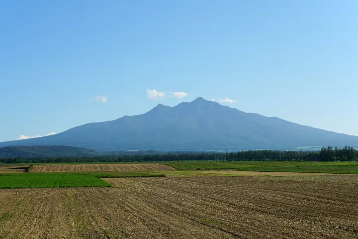
Mount Shari is a 1,547 m stratovolcano in eastern Hokkaido, rising near the base of the Shiretoko Peninsula and straddling the towns of Shari, Kiyosato, and Shibetsu within Sharidake Prefectural Natural Park. Its symmetrical cone has earned it the nickname "Shari Fuji" and a place among the Hyakumeizan and the 100 Mountains of Flowers. The standard route from Kiyosato climbs from the Seigakusō hut at the fifth station via a stream course on the ascent and a ridge course on the descent, reaching the summit in roughly four hours. From the top, climbers can see the Shiretoko range, the Sea of Okhotsk, and Kunashiri Island.
Mount Shari at a glance
- Weather: The most settled day in the next 7 days is Mon, November 9: cloudy, gusts up to 11 m/s. Wed, Nov 4, Thu, Nov 5, Sat, Nov 7, Sun, Nov 8: strong wind (gusts up to 30 m/s).
- Route: The shortest is Mount Shari Old Trail–New Trail Circuit: about 6 h 19 min, 9.9 km, about 1,040 m of climbing.
Mount Shari weather (hourly, 14 days)
Sunrise today 05:59, sunset 16:11
| Tue, 11/3 | Wed, 11/4 | Thu, 11/5 | Fri, 11/6 | Sat, 11/7 | Sun, 11/8 | Mon, 11/9 | Tue, 11/10 | Wed, 11/11 | Thu, 11/12 | Fri, 11/13 | Sat, 11/14 | Sun, 11/15 | Mon, 11/16 | Tue, 11/17 | |||||||||||||||||||||||||||||||||||||||||||||||||||||||||||||||||||||||
|---|---|---|---|---|---|---|---|---|---|---|---|---|---|---|---|---|---|---|---|---|---|---|---|---|---|---|---|---|---|---|---|---|---|---|---|---|---|---|---|---|---|---|---|---|---|---|---|---|---|---|---|---|---|---|---|---|---|---|---|---|---|---|---|---|---|---|---|---|---|---|---|---|---|---|---|---|---|---|---|---|---|---|---|---|---|
| Japan time | 21 | 23 | 1 | 3 | 5 | 7 | 9 | 11 | 13 | 15 | 17 | 19 | 21 | 0 | 3 | 6 | 9 | 12 | 15 | 18 | 21 | 0 | 3 | 6 | 9 | 12 | 15 | 18 | 21 | 0 | 3 | 6 | 9 | 12 | 15 | 18 | 21 | 0 | 3 | 6 | 9 | 12 | 15 | 18 | 21 | 0 | 3 | 6 | 9 | 12 | 15 | 21 | 3 | 9 | 15 | 21 | 3 | 9 | 15 | 21 | 3 | 9 | 15 | 21 | 3 | 9 | 15 | 21 | 3 | 9 | 15 | 21 | 3 | 9 | 15 | 21 | 3 | 9 | 15 | 21 | 3 | 9 | 15 | 21 | |
 | | |   |   |  |   |   |   | | |  | | | | |   | | |   | | | | |   | | |   | | | | | |   | | | | | | |   | | | | |   | | | | | | | | | | | | | | | | | |   |   | | | | | | |  | | | | |   | |   | | | | | | ||
| Temperature | °C | -7° | -8° | -9° | -8° | -7° | -6° | -3° | -3° | -4° | -4° | -9° | -8° | -6° | -6° | -5° | -5° | 2° | 3° | 2° | 2° | 2° | 2° | 2° | 1° | 2° | 2° | 2° | 1° | 1° | -3° | -5° | -8° | -5° | -4° | -5° | -8° | -8° | -7° | -7° | -7° | -5° | -4° | -5° | -8° | -9° | -10° | -10° | -10° | -7° | -6° | -8° | -9° | -11° | -7° | -7° | -10° | -9° | -6° | -5° | -9° | -8° | -4° | -4° | -7° | -9° | -9° | -8° | -10° | -8° | -7° | -7° | -9° | -9° | -1° | -2° | -2° | -3° | -3° | -6° | -8° | -9° | -8° | -7° | -10° |
| Precipitation | mm | 0.2 | 0.3 | 0.7 | 1.3 | 1.8 | 4.3 | 2.8 | 2.1 | 1.1 | 0.1 | 0.2 | 0.7 | 0.5 | 0.6 | 0.7 | 0.3 | 0.8 | 1.5 | 0.6 | 0.6 | 0.2 | 1.3 | 1.7 | 3.9 | 2.5 | 3.0 | 1.8 | 0.4 | ||||||||||||||||||||||||||||||||||||||||||||||||||||||||
| New snow | cm | 0.1 | <.1 | <.1 | 0.1 | 0.2 | <.1 | <.1 | 0.5 | <.1 | <.1 | 0.6 | 0.7 | 0.3 | 0.8 | 1.4 | 0.6 | 0.6 | 0.1 | 2.4 | 2.4 | 3.0 | 1.8 | 0.4 | |||||||||||||||||||||||||||||||||||||||||||||||||||||||||||||
| Snow depth | cm | 1 | 1 | 1 | 1 | 1 | 1 | 1 | 1 | 1 | 1 | 1 | 1 | 1 | 1 | 1 | 1 | 1 | <1 | 0 | 0 | 0 | 0 | 0 | 0 | 0 | 0 | 0 | 0 | 0 | 0 | 0 | 0 | 0 | 0 | 0 | 0 | 0 | 0 | 0 | 0 | 0 | 0 | 0 | 0 | 0 | 0 | 0 | 0 | 0 | 0 | 0 | 0 | 0 | 0 | 0 | 0 | 0 | <1 | <1 | <1 | 0 | 0 | 0 | <1 | <1 | 2 | 2 | 2 | 2 | 3 | 3 | 3 | 3 | 3 | 2 | 2 | 1 | 1 | 2 | 4 | 6 | 7 | 7 | 7 |
| Wind | m/s | 4 | 2 | 1 | 3 | 4 | 2 | 7 | 6 | 5 | 3 | 1 | 1 | 2 | 3 | 3 | 3 | 4 | 4 | 4 | 3 | 3 | 3 | 2 | 2 | 2 | 2 | 2 | 3 | 3 | 3 | 4 | 4 | 4 | 7 | 5 | 4 | 6 | 7 | 7 | 8 | 10 | 9 | 8 | 7 | 5 | 3 | 3 | 2 | 4 | 3 | 1 | 2 | 2 | 3 | 2 | 0 | 1 | 2 | 1 | 1 | 0 | 1 | 1 | 3 | 4 | 5 | 5 | 6 | 7 | 6 | 4 | 0 | 1 | 2 | 2 | 3 | 2 | 2 | 5 | 6 | 5 | 5 | 3 | 1 |
| Wind gusts | m/s | 12 | 12 | 10 | 9 | 12 | 13 | 21 | 21 | 19 | 14 | 9 | 5 | 8 | 11 | 11 | 10 | 18 | 15 | 15 | 12 | 11 | 10 | 10 | 7 | 6 | 6 | 8 | 10 | 14 | 11 | 14 | 15 | 14 | 20 | 21 | 16 | 19 | 23 | 23 | 26 | 28 | 30 | 27 | 24 | 21 | 15 | 12 | 10 | 10 | 11 | 8 | 12 | 8 | 9 | 9 | 6 | 3 | 6 | 7 | 4 | 3 | 4 | 5 | 8 | 12 | 14 | 19 | 25 | 20 | 20 | 17 | 12 | 5 | 7 | 10 | 10 | 12 | 11 | 15 | 19 | 19 | 19 | 15 | 8 |
| Wind dir. | ↓ | ↓ | ↓ | ↓ | ↓ | ↓ | ↓ | ↓ | ↓ | ↓ | ↓ | ↓ | ↓ | ↓ | ↓ | ↓ | ↓ | ↓ | ↓ | ↓ | ↓ | ↓ | ↓ | ↓ | ↓ | ↓ | ↓ | ↓ | ↓ | ↓ | ↓ | ↓ | ↓ | ↓ | ↓ | ↓ | ↓ | ↓ | ↓ | ↓ | ↓ | ↓ | ↓ | ↓ | ↓ | ↓ | ↓ | ↓ | ↓ | ↓ | ↓ | ↓ | ↓ | ↓ | ↓ | ↓ | ↓ | ↓ | ↓ | ↓ | ↓ | ↓ | ↓ | ↓ | ↓ | ↓ | ↓ | ↓ | ↓ | ↓ | ↓ | ↓ | ↓ | ↓ | ↓ | ↓ | ↓ | ↓ | ↓ | ↓ | ↓ | ↓ | ↓ | ↓ | |
Mount Shari hiking routes
Hiking times are estimates calculated from the terrain.
Huts, campsites and lodging near Mount Shari
Mountain huts
Lists that include Mount Shari
100 Famous Japanese Mountains · Japan 200 Famous Mountains · Japan's 300 Famous Mountains · 100 Famous Mountains of Flowers · New 100 Famous Flower Mountains · 100 Famous Hot Spring Mountains · 100 Fujis of Japan · Hokkaido 100 Famous Mountains · Elevations of 1003 Mountains of Japan · 1000 Mountains of Japan
Mount Shari facts
- Also known as
- オンネヌプリ
- Elevation
- 1,547 m
- Location
- Shari, Hokkaido / Kiyosato, Hokkaido
43.765729, 144.717670 - Website
- www.kiyosatokankou.com
- Access Information
- www.town.kiyosato.hokkaido.jp
- Wikipedia
- ja.wikipedia.org