
Mount Rausu
羅臼岳
Shari, Hokkaido / Rausu, Hokkaido · Elevation 1,660 m
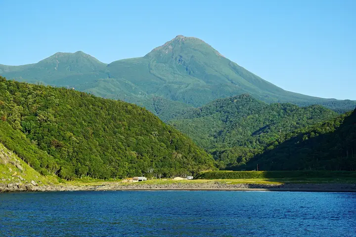
Mount Rausu is a 1,660 m stratovolcano and the highest peak of the Shiretoko Peninsula in eastern Hokkaido, lying within Shiretoko National Park (a UNESCO World Heritage site). Its symmetrical cone has earned it the nickname "Shiretoko Fuji." It is climbed via two routes — Iwaobetsu on the Shari side and Rausu Onsen on the Rausu side — and the summit offers sweeping views of the Shiretoko range the Sea of Okhotsk, the Nemuro Strait and Kunashiri Island. The area is active brown-bear habitat, and bear-aware preparation is necessary. The mountain also supports abundant alpine plants.
Mount Rausu at a glance
- Weather: The most settled day in the next 7 days is Thu, November 5: cloudy, gusts up to 12 m/s. Sat, Nov 7, Sun, Nov 8: strong wind (gusts up to 26 m/s).
- Route: The shortest is Mount Rausu Return from Kinoshita Hut via Rausudaira: about 9 h 2 min, 13.7 km, about 1,450 m of climbing.
Mount Rausu weather (hourly, 14 days)
Sunrise today 05:58, sunset 16:09
| Tue, 11/3 | Wed, 11/4 | Thu, 11/5 | Fri, 11/6 | Sat, 11/7 | Sun, 11/8 | Mon, 11/9 | Tue, 11/10 | Wed, 11/11 | Thu, 11/12 | Fri, 11/13 | Sat, 11/14 | Sun, 11/15 | Mon, 11/16 | Tue, 11/17 | |||||||||||||||||||||||||||||||||||||||||||||||||||||||||||||||||||||||
|---|---|---|---|---|---|---|---|---|---|---|---|---|---|---|---|---|---|---|---|---|---|---|---|---|---|---|---|---|---|---|---|---|---|---|---|---|---|---|---|---|---|---|---|---|---|---|---|---|---|---|---|---|---|---|---|---|---|---|---|---|---|---|---|---|---|---|---|---|---|---|---|---|---|---|---|---|---|---|---|---|---|---|---|---|---|
| Japan time | 15 | 17 | 19 | 21 | 23 | 1 | 3 | 5 | 7 | 9 | 11 | 13 | 15 | 18 | 21 | 0 | 3 | 6 | 9 | 12 | 15 | 18 | 21 | 0 | 3 | 6 | 9 | 12 | 15 | 18 | 21 | 0 | 3 | 6 | 9 | 12 | 15 | 18 | 21 | 0 | 3 | 6 | 9 | 12 | 15 | 18 | 21 | 0 | 3 | 6 | 9 | 15 | 21 | 3 | 9 | 15 | 21 | 3 | 9 | 15 | 21 | 3 | 9 | 15 | 21 | 3 | 9 | 15 | 21 | 3 | 9 | 15 | 21 | 3 | 9 | 15 | 21 | 3 | 9 | 15 | 21 | 3 | 9 | 15 | |
  |   |   | |   |  |   | |   |   | |   | |  |   | | |   | | |   |   |   | | | |   | | | | | | |   | | |  | | | | | | |   | | | | | | | | | | |   | | | | | | | | | | | | | | | | | | | | | | |   | |   | | | | | ||
| Temperature | °C | -6° | -7° | -7° | -7° | -6° | -8° | -9° | -7° | -7° | -4° | -5° | -4° | -5° | -7° | -8° | -6° | -5° | -5° | 0° | 4° | 2° | 0° | 0° | 1° | 1° | 0° | 1° | 1° | 1° | 1° | 0° | -2° | -5° | -7° | -5° | -4° | -5° | -7° | -8° | -8° | -8° | -9° | -8° | -7° | -7° | -7° | -6° | -7° | -7° | -7° | -7° | -7° | -10° | -9° | -7° | -8° | -11° | -9° | -6° | -6° | -8° | -9° | -5° | -5° | -8° | -9° | -9° | -9° | -10° | -8° | -7° | -7° | -10° | -10° | -2° | -2° | -1° | -2° | -3° | -6° | -8° | -8° | -8° | -8° |
| Precipitation | mm | 0.9 | 0.8 | 0.3 | 0.2 | 0.1 | 0.4 | 1.0 | 0.2 | 0.8 | 6 | 0.8 | 2.4 | 0.4 | 0.8 | 1.2 | 0.4 | 0.4 | 0.7 | 0.5 | 0.3 | 0.1 | 0.3 | 0.4 | 0.3 | 1.0 | 1.2 | 1.1 | 0.3 | 0.2 | 0.4 | 0.6 | 0.6 | 0.1 | 1.1 | 0.8 | 0.3 | 0.2 | 0.5 | 1.6 | 2.0 | 2.6 | 2.4 | 1.5 | 0.6 | 0.8 | 0.9 | 2.7 | 2.2 | 0.6 | 1.0 | 1.8 | |||||||||||||||||||||||||||||||||
| New snow | cm | 0.8 | 0.6 | 0.3 | 0.2 | <.1 | <.1 | 0.2 | 0.3 | 0.9 | 0.1 | <.1 | <.1 | 0.2 | <.1 | 0.1 | 0.3 | 0.4 | 0.3 | 1.0 | 1.2 | 1.1 | 0.3 | 0.2 | 0.3 | 0.5 | 0.6 | 0.1 | 1.1 | 0.8 | 0.3 | <.1 | 0.2 | <.1 | 0.5 | 1.6 | 2.0 | 2.6 | 2.3 | 1.5 | 0.6 | <.1 | 0.9 | 1.5 | 0.6 | 1.0 | 1.7 | ||||||||||||||||||||||||||||||||||||||
| Snow depth | cm | <1 | <1 | 2 | 2 | 2 | 2 | 2 | 2 | 2 | 2 | 2 | 2 | 2 | 2 | 2 | 2 | 2 | 2 | 2 | <1 | <1 | 0 | 0 | 0 | 0 | 0 | 0 | 0 | 0 | 0 | 0 | 0 | 0 | 0 | 0 | 0 | 0 | 0 | 0 | <1 | <1 | <1 | <1 | 2 | 2 | 2 | 2 | 2 | 3 | 3 | 3 | 3 | 4 | 4 | 4 | 3 | 3 | 3 | 3 | 3 | 3 | 3 | 3 | 3 | 3 | 5 | 6 | 7 | 8 | 9 | 9 | 8 | 8 | 8 | 8 | 7 | 7 | 6 | 6 | 6 | 6 | 6 | 7 | 8 |
| Wind | m/s | 4 | 3 | 3 | 3 | 3 | 1 | 1 | 2 | 2 | 4 | 5 | 5 | 3 | 0 | 1 | 1 | 1 | 1 | 1 | 4 | 3 | 2 | 1 | 1 | 2 | 2 | 2 | 2 | 3 | 2 | 2 | 4 | 1 | 1 | 4 | 6 | 6 | 5 | 3 | 6 | 7 | 7 | 8 | 8 | 8 | 9 | 10 | 7 | 5 | 5 | 5 | 3 | 2 | 3 | 2 | 1 | 0 | 0 | 2 | 1 | 1 | 1 | 1 | 0 | 2 | 4 | 4 | 3 | 4 | 5 | 4 | 4 | 1 | 1 | 1 | 2 | 1 | 1 | 1 | 4 | 6 | 6 | 3 | 2 |
| Wind gusts | m/s | 12 | 11 | 11 | 11 | 12 | 10 | 6 | 8 | 11 | 14 | 15 | 15 | 14 | 10 | 6 | 7 | 6 | 6 | 8 | 12 | 12 | 10 | 6 | 8 | 7 | 7 | 6 | 7 | 10 | 9 | 8 | 10 | 10 | 10 | 14 | 18 | 19 | 18 | 19 | 20 | 23 | 23 | 23 | 26 | 26 | 26 | 28 | 28 | 18 | 14 | 13 | 12 | 9 | 10 | 9 | 8 | 4 | 3 | 6 | 6 | 3 | 4 | 5 | 6 | 7 | 10 | 14 | 14 | 17 | 15 | 15 | 12 | 9 | 5 | 4 | 7 | 7 | 7 | 6 | 11 | 15 | 18 | 18 | 11 |
| Wind dir. | ↓ | ↓ | ↓ | ↓ | ↓ | ↓ | ↓ | ↓ | ↓ | ↓ | ↓ | ↓ | ↓ | ↓ | ↓ | ↓ | ↓ | ↓ | ↓ | ↓ | ↓ | ↓ | ↓ | ↓ | ↓ | ↓ | ↓ | ↓ | ↓ | ↓ | ↓ | ↓ | ↓ | ↓ | ↓ | ↓ | ↓ | ↓ | ↓ | ↓ | ↓ | ↓ | ↓ | ↓ | ↓ | ↓ | ↓ | ↓ | ↓ | ↓ | ↓ | ↓ | ↓ | ↓ | ↓ | ↓ | ↓ | ↓ | ↓ | ↓ | ↓ | ↓ | ↓ | ↓ | ↓ | ↓ | ↓ | ↓ | ↓ | ↓ | ↓ | ↓ | ↓ | ↓ | ↓ | ↓ | ↓ | ↓ | ↓ | ↓ | ↓ | ↓ | ↓ | ↓ | |
Mount Rausu live cameras
Mount Rausu hiking routes
Hiking times are estimates calculated from the terrain.
Huts, campsites and lodging near Mount Rausu
Campsites
- 羅臼平キャンプ指定地
- 三ツ峰キャンプ指定地
- 二ツ池キャンプ指定地
Lists that include Mount Rausu
100 Famous Japanese Mountains · Japan 200 Famous Mountains · Japan's 300 Famous Mountains · 100 Famous Mountains of Flowers · New 100 Famous Flower Mountains · 100 Famous Hot Spring Mountains · 100 Fujis of Japan · Hokkaido 100 Famous Mountains · Elevations of 1003 Mountains of Japan · 1000 Mountains of Japan
Mount Rausu facts
- Elevation
- 1,660 m
- Location
- Shari, Hokkaido / Rausu, Hokkaido
44.075924, 145.122228 - National Park
- 知床国立公園
- Volcano
- Active volcano (羅臼岳)
- Website
- policies.env.go.jp
- Access Information
- policies.env.go.jp
- Wikipedia
- en.wikipedia.org