
Mount Pirikanupuri
ピリカヌプリ
Taiki, Hokkaido · Elevation 1,630 m
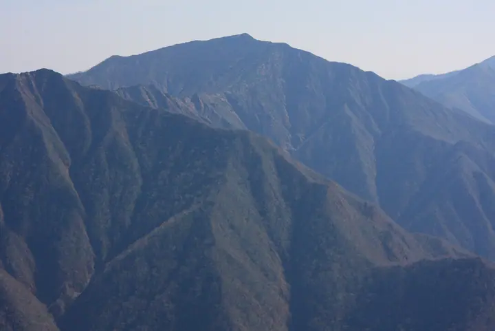
Mount Pirikanupuri is a 1,631 m peak on the border between Taiki and Urakawa towns in southern Hokkaido, in the southern part of the Hidaka Range. The name means 'beautiful mountain' in the Ainu language and is the only mountain in Hokkaido to carry the epithet 'pirika'. Seen from Mount Toyoni to the south it rises in a 300 m sweep, and together with Mount Kamui and Mount Soematsu it forms the 'Three Mountains of South Hidaka'. There is no maintained trail; the peak is climbed only by an experienced stream-climb of the right fork of the Nubinai River, or by a snow-season ridge traverse. It lies within Hidaka-Sanmyaku-Erimo-Tokachi National Park designated in 2024.
Mount Pirikanupuri at a glance
- Weather: The most settled day in the next 7 days is Wed, November 4: clear, gusts up to 18 m/s. Wed, Nov 4, Sat, Nov 7, Sun, Nov 8, Mon, Nov 9: strong wind (gusts up to 25 m/s).
Mount Pirikanupuri weather (hourly, 14 days)
Sunrise today 06:03, sunset 16:21
| Tue, 11/3 | Wed, 11/4 | Thu, 11/5 | Fri, 11/6 | Sat, 11/7 | Sun, 11/8 | Mon, 11/9 | Tue, 11/10 | Wed, 11/11 | Thu, 11/12 | Fri, 11/13 | Sat, 11/14 | Sun, 11/15 | Mon, 11/16 | Tue, 11/17 | |||||||||||||||||||||||||||||||||||||||||||||||||||||||||||||||||||||||
|---|---|---|---|---|---|---|---|---|---|---|---|---|---|---|---|---|---|---|---|---|---|---|---|---|---|---|---|---|---|---|---|---|---|---|---|---|---|---|---|---|---|---|---|---|---|---|---|---|---|---|---|---|---|---|---|---|---|---|---|---|---|---|---|---|---|---|---|---|---|---|---|---|---|---|---|---|---|---|---|---|---|---|---|---|---|
| Japan time | 15 | 17 | 19 | 21 | 23 | 1 | 3 | 5 | 7 | 9 | 11 | 13 | 15 | 18 | 21 | 0 | 3 | 6 | 9 | 12 | 15 | 18 | 21 | 0 | 3 | 6 | 9 | 12 | 15 | 18 | 21 | 0 | 3 | 6 | 9 | 12 | 15 | 18 | 21 | 0 | 3 | 6 | 9 | 12 | 15 | 18 | 21 | 0 | 3 | 6 | 9 | 15 | 21 | 3 | 9 | 15 | 21 | 3 | 9 | 15 | 21 | 3 | 9 | 15 | 21 | 3 | 9 | 15 | 21 | 3 | 9 | 15 | 21 | 3 | 9 | 15 | 21 | 3 | 9 | 15 | 21 | 3 | 9 | 15 | |
  |  | | | |   |   | | | |  | | |  | |   | | |   |   | |   | | | | | | |   |   | |   | | |   | |   | |   | | | |   | | | | | | | | | |   | | | |   | | | | | | | |   | | | | |  | | | | | | | | | | |   |  | | | ||
| Temperature | °C | -3° | -6° | -7° | -7° | -8° | -6° | -5° | -4° | -5° | -3° | -2° | -1° | -1° | -7° | -6° | -5° | -4° | -3° | 2° | 2° | 2° | 2° | 1° | 2° | 2° | 2° | 3° | 4° | 3° | 0° | -3° | -6° | -8° | -9° | -8° | -7° | -8° | -9° | -9° | -9° | -10° | -10° | -8° | -6° | -7° | -9° | -9° | -10° | -11° | -10° | -7° | -7° | -12° | -12° | -6° | -6° | -8° | -9° | -8° | -6° | -9° | -10° | -6° | -5° | -11° | -12° | -9° | -8° | -10° | -12° | -4° | -4° | -8° | -8° | -1° | -2° | -2° | -3° | 0° | -3° | -8° | -10° | -5° | -4° |
| Precipitation | mm | 1.4 | 0.5 | 1.5 | 1.0 | 1.8 | 7 | 0.9 | 1.9 | 2.6 | 10 | 2.1 | 1.2 | 1.0 | 0.8 | 0.1 | 0.4 | 1.2 | 1.2 | 0.3 | 2.6 | 4.0 | 2.2 | 0.8 | 0.1 | 1.8 | 3.1 | 0.4 | 0.5 | 0.5 | 0.6 | ||||||||||||||||||||||||||||||||||||||||||||||||||||||
| New snow | cm | 1.4 | 0.5 | 0.6 | 0.2 | 0.4 | 1.2 | 1.2 | 0.3 | <.1 | <.1 | <.1 | 2.6 | 4.0 | 2.2 | 0.8 | <.1 | <.1 | <.1 | ||||||||||||||||||||||||||||||||||||||||||||||||||||||||||||||||||
| Snow depth | cm | 0 | 0 | 0 | 0 | 0 | 0 | <1 | 1 | 1 | 1 | 1 | 1 | 1 | <1 | <1 | <1 | <1 | <1 | <1 | <1 | 0 | 0 | 0 | 0 | 0 | 0 | 0 | 0 | 0 | 0 | 0 | 0 | <1 | <1 | 1 | 2 | 2 | 2 | 2 | 2 | 2 | 2 | 2 | 2 | 2 | 2 | 2 | 1 | 1 | 1 | 1 | 1 | 1 | 1 | 1 | 1 | 1 | 3 | 6 | 7 | 7 | 7 | 7 | 7 | 7 | 7 | 7 | 6 | 6 | 6 | 6 | 6 | 6 | 6 | 5 | 4 | 3 | 3 | 3 | 2 | 2 | 2 | 2 | 2 |
| Wind | m/s | 5 | 4 | 4 | 4 | 2 | 3 | 4 | 5 | 5 | 6 | 5 | 3 | 3 | 2 | 2 | 2 | 2 | 1 | 3 | 2 | 1 | 0 | 1 | 0 | 1 | 1 | 2 | 4 | 5 | 9 | 9 | 9 | 9 | 7 | 7 | 8 | 9 | 11 | 9 | 8 | 9 | 8 | 9 | 9 | 9 | 8 | 6 | 5 | 3 | 3 | 4 | 5 | 3 | 2 | 2 | 2 | 3 | 4 | 3 | 1 | 1 | 2 | 3 | 3 | 3 | 2 | 4 | 3 | 2 | 1 | 1 | 1 | 1 | 2 | 3 | 3 | 2 | 1 | 2 | 1 | 2 | 2 | 0 | 2 |
| Wind gusts | m/s | 16 | 14 | 12 | 13 | 13 | 11 | 16 | 16 | 16 | 18 | 17 | 16 | 11 | 9 | 8 | 9 | 8 | 7 | 9 | 9 | 8 | 5 | 4 | 4 | 3 | 5 | 8 | 13 | 14 | 25 | 26 | 27 | 27 | 24 | 22 | 23 | 25 | 29 | 29 | 26 | 24 | 25 | 25 | 25 | 24 | 23 | 21 | 17 | 14 | 11 | 12 | 16 | 14 | 9 | 8 | 8 | 7 | 12 | 11 | 9 | 4 | 7 | 10 | 15 | 12 | 9 | 12 | 12 | 10 | 8 | 5 | 5 | 6 | 7 | 9 | 10 | 10 | 8 | 6 | 6 | 6 | 7 | 6 | 8 |
| Wind dir. | ↓ | ↓ | ↓ | ↓ | ↓ | ↓ | ↓ | ↓ | ↓ | ↓ | ↓ | ↓ | ↓ | ↓ | ↓ | ↓ | ↓ | ↓ | ↓ | ↓ | ↓ | ↓ | ↓ | ↓ | ↓ | ↓ | ↓ | ↓ | ↓ | ↓ | ↓ | ↓ | ↓ | ↓ | ↓ | ↓ | ↓ | ↓ | ↓ | ↓ | ↓ | ↓ | ↓ | ↓ | ↓ | ↓ | ↓ | ↓ | ↓ | ↓ | ↓ | ↓ | ↓ | ↓ | ↓ | ↓ | ↓ | ↓ | ↓ | ↓ | ↓ | ↓ | ↓ | ↓ | ↓ | ↓ | ↓ | ↓ | ↓ | ↓ | ↓ | ↓ | ↓ | ↓ | ↓ | ↓ | ↓ | ↓ | ↓ | ↓ | ↓ | ↓ | ↓ | ↓ | |
Lists that include Mount Pirikanupuri
Elevations of 1003 Mountains of Japan · 1000 Mountains of Japan
Mount Pirikanupuri facts
- Elevation
- 1,630 m
- Location
- Taiki, Hokkaido
42.402228, 142.966799 - National Park
- 日高山脈襟裳十勝国立公園
- Website
- hidakasanmyaku-sangakucenter.jp
- Wikipedia
- ja.wikipedia.org