
Mount Omuro
大室山
Ito, Shizuoka · Elevation 580 m
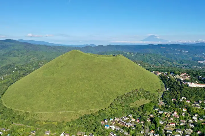
Mt. Omuroyama is a 580-meter monogenetic volcano in Ito City, Shizuoka Prefecture — the largest scoria cone in the eastern Izu volcano group, formed about 4,000 years ago. Its perfectly bowl-shaped silhouette and 300-meter-wide bowl-like crater are preserved by the centuries-old annual "yamayaki" grass-burning ritual held each February, and the mountain is both a designated National Natural Monument and an Izu Peninsula UNESCO Global Geopark geosite. It lies within Fuji-Hakone-Izu National Park; a chairlift carries visitors to the summit, where a crater-rim walking path, the Sengen Shrine, and sweeping views of Mt. Fuji, Sagami Bay, and the Izu Islands await. Archery is also available inside the crater.
Mount Omuro at a glance
- Weather: The most settled day in the next 7 days is Fri, November 6: clear, gusts up to 6 m/s.
- Route: The shortest is Mount Omuro, a Bowl-shaped Natural Monument Volcano: a 360-degree Walk around the Crater Rim: about 19 min, 955 m, about 50 m of climbing.
Mount Omuro weather (hourly, 14 days)
Sunrise today 06:06, sunset 16:49
| Tue, 11/3 | Wed, 11/4 | Thu, 11/5 | Fri, 11/6 | Sat, 11/7 | Sun, 11/8 | Mon, 11/9 | Tue, 11/10 | Wed, 11/11 | Thu, 11/12 | Fri, 11/13 | Sat, 11/14 | Sun, 11/15 | Mon, 11/16 | Tue, 11/17 | |||||||||||||||||||||||||||||||||||||||||||||||||||||||||||||||||||||||
|---|---|---|---|---|---|---|---|---|---|---|---|---|---|---|---|---|---|---|---|---|---|---|---|---|---|---|---|---|---|---|---|---|---|---|---|---|---|---|---|---|---|---|---|---|---|---|---|---|---|---|---|---|---|---|---|---|---|---|---|---|---|---|---|---|---|---|---|---|---|---|---|---|---|---|---|---|---|---|---|---|---|---|---|---|---|
| Japan time | 15 | 17 | 19 | 21 | 23 | 1 | 3 | 5 | 7 | 9 | 11 | 13 | 15 | 18 | 21 | 0 | 3 | 6 | 9 | 12 | 15 | 18 | 21 | 0 | 3 | 6 | 9 | 12 | 15 | 18 | 21 | 0 | 3 | 6 | 9 | 12 | 15 | 18 | 21 | 0 | 3 | 6 | 9 | 12 | 15 | 18 | 21 | 0 | 3 | 6 | 9 | 15 | 21 | 3 | 9 | 15 | 21 | 3 | 9 | 15 | 21 | 3 | 9 | 15 | 21 | 3 | 9 | 15 | 21 | 3 | 9 | 15 | 21 | 3 | 9 | 15 | 21 | 3 | 9 | 15 | 21 | 3 | 9 | 15 | |
  |   |   | | | |   | |   | |   | | | | | | | | |   | | |   | | | | |   |  |  | | |   |   | | |   | | | | | | | | | | | | | | | | | | | | | | | |   | | | | | | | | | | | | | | | | | | | | | | | | ||
| Temperature | °C | 15° | 13° | 13° | 13° | 13° | 12° | 11° | 11° | 11° | 11° | 12° | 12° | 11° | 10° | 10° | 11° | 11° | 11° | 14° | 17° | 14° | 13° | 12° | 12° | 11° | 12° | 17° | 19° | 20° | 14° | 12° | 9° | 9° | 9° | 13° | 15° | 14° | 11° | 11° | 9° | 7° | 7° | 11° | 12° | 12° | 9° | 10° | 10° | 9° | 9° | 9° | 11° | 9° | 8° | 9° | 11° | 7° | 7° | 11° | 14° | 6° | 5° | 10° | 11° | 7° | 8° | 12° | 13° | 8° | 6° | 8° | 10° | 6° | 6° | 12° | 13° | 12° | 13° | 17° | 19° | 12° | 8° | 9° | 10° |
| Precipitation | mm | 0.3 | 0.6 | 0.2 | 0.2 | 0.9 | 2.8 | 6 | 3.7 | 9 | 4.7 | 0.3 | 0.7 | 3.4 | 3.9 | 0.2 | 0.2 | 0.2 | 0.1 | 0.1 | 0.5 | 0.1 | 0.5 | 1.2 | 0.1 | 0.5 | 0.2 | 0.1 | 2.4 | 13 | 32 | 7 | |||||||||||||||||||||||||||||||||||||||||||||||||||||
| New snow | cm | ||||||||||||||||||||||||||||||||||||||||||||||||||||||||||||||||||||||||||||||||||||
| Snow depth | cm | 0 | 0 | 0 | 0 | 0 | 0 | 0 | 0 | 0 | 0 | 0 | 0 | 0 | 0 | 0 | 0 | 0 | 0 | 0 | 0 | 0 | 0 | 0 | 0 | 0 | 0 | 0 | 0 | 0 | 0 | 0 | 0 | 0 | 0 | 0 | 0 | 0 | 0 | 0 | 0 | 0 | 0 | 0 | 0 | 0 | 0 | 0 | 0 | 0 | 0 | 0 | 0 | 0 | 0 | 0 | 0 | 0 | 0 | 0 | 0 | 0 | 0 | 0 | 0 | 0 | 0 | 0 | 0 | 0 | 0 | 0 | 0 | 0 | 0 | 0 | 0 | 0 | 0 | 0 | 0 | 0 | 0 | 0 | 0 |
| Wind | m/s | 3 | 2 | 2 | 2 | 2 | 2 | 4 | 3 | 4 | 4 | 5 | 5 | 6 | 4 | 4 | 3 | 1 | 1 | 1 | 2 | 1 | 0 | 0 | 0 | 1 | 1 | 1 | 1 | 0 | 2 | 2 | 1 | 1 | 2 | 2 | 2 | 4 | 3 | 2 | 1 | 0 | 1 | 2 | 2 | 2 | 0 | 2 | 1 | 1 | 2 | 2 | 3 | 3 | 3 | 4 | 2 | 0 | 2 | 1 | 2 | 0 | 1 | 2 | 1 | 1 | 1 | 1 | 2 | 3 | 2 | 3 | 2 | 1 | 1 | 0 | 0 | 2 | 1 | 1 | 1 | 3 | 3 | 4 | 3 |
| Wind gusts | m/s | 9 | 8 | 5 | 5 | 6 | 6 | 10 | 10 | 10 | 12 | 13 | 14 | 15 | 15 | 12 | 12 | 9 | 5 | 4 | 6 | 6 | 4 | 2 | 3 | 5 | 6 | 6 | 5 | 5 | 8 | 9 | 6 | 5 | 4 | 6 | 8 | 10 | 11 | 11 | 7 | 4 | 3 | 7 | 7 | 7 | 6 | 4 | 5 | 3 | 5 | 6 | 9 | 9 | 10 | 11 | 11 | 6 | 7 | 16 | 8 | 6 | 3 | 6 | 6 | 3 | 3 | 4 | 8 | 8 | 8 | 8 | 8 | 5 | 4 | 4 | 7 | 7 | 12 | 9 | 11 | 11 | 9 | 11 | 11 |
| Wind dir. | ↓ | ↓ | ↓ | ↓ | ↓ | ↓ | ↓ | ↓ | ↓ | ↓ | ↓ | ↓ | ↓ | ↓ | ↓ | ↓ | ↓ | ↓ | ↓ | ↓ | ↓ | ↓ | ↓ | ↓ | ↓ | ↓ | ↓ | ↓ | ↓ | ↓ | ↓ | ↓ | ↓ | ↓ | ↓ | ↓ | ↓ | ↓ | ↓ | ↓ | ↓ | ↓ | ↓ | ↓ | ↓ | ↓ | ↓ | ↓ | ↓ | ↓ | ↓ | ↓ | ↓ | ↓ | ↓ | ↓ | ↓ | ↓ | ↓ | ↓ | ↓ | ↓ | ↓ | ↓ | ↓ | ↓ | ↓ | ↓ | ↓ | ↓ | ↓ | ↓ | ↓ | ↓ | ↓ | ↓ | ↓ | ↓ | ↓ | ↓ | ↓ | ↓ | ↓ | ↓ | |
Mount Omuro hiking routes
Hiking times are estimates calculated from the terrain.
Huts, campsites and lodging near Mount Omuro
Campsites
- K's Camp Glamping
- Kusamakura Camping Ground
Lodging
- Grandvert Izu
- bekka izu
- Izushaboten Village
- Suite Villa
- Izu Kogen Silent Hills
Lists that include Mount Omuro
100 Fujis of Japan · 100 Mountains of Shizuoka · Elevations of 1003 Mountains of Japan
Mount Omuro facts
- Also known as
- 伊豆富士 · スコリア丘
- Elevation
- 580 m
- Location
- Ito, Shizuoka
34.903139, 139.094757 - National Park
- 富士箱根伊豆国立公園
- Volcano
- Active volcano (伊豆東部火山群)
- Website
- omuroyama.com
- Access Information
- omuroyama.com
- Wikipedia
- ja.wikipedia.org